Science Spotlight

rss
  • October 15, 2020

Market Squid Reproducing. Photo credit: Mark Conlin Photography

chart showing monetary value of various commercially fished species, 2015-2019 - click to enlarge in new window
Highest value marine fisheries, 2015-2019 - click to enlarge

fishing fleet ship using a net to catch squid on the ocean - click to enlarge in new window
Squid fishing fleet near Monterey. CDFW photo by Carrie Wilson - click to enlarge

three fishing fleet ships with lights at night on the ocean - click to enlarge in new window
Squid fishing fleet at night. CDFW photo by Carrie Wilson - click to enlarge

Arriving on the heels of the farm to fork movement, the COVID-19 pandemic has disrupted supply chains and altered product demand, which has inspired businesses to restructure and Californians to pay particular attention to where their food comes from. Many understand that almonds, artichokes or lettuce are grown in their own backyard, mostly in the Central or Salinas Valleys. But when residents are asked about wild-caught food sources coming from the ocean, tuna, salmon or perhaps rockfish might immediately come to mind. While those are indeed popular fisheries, the largest of California’s commercial fisheries actually target invertebrates, not fish!

Invertebrates are animals without a backbone, such as the tidepool favorites, sea stars and anemones. But there are many more invertebrates around the world, both swimming and sedentary, that are highly sought after for food – and their popularity is on the rise. California’s largest marine commercial fisheries in terms of volume and value are market squid and Dungeness crab, with well over 100 million pounds landed and more than $30 million in revenue in a typical year for the squid fishery.

Market squid, the invertebrate known to diners as the popular dish calamari, use ocean currents, jet propulsion and prehistoric instincts to travel up and down the continental shelf of California. These slippery siblings of octopuses live very short lives (less than nine months) and produce heaps of eggs, somewhere on the order of 2,000 to 7,000 per female!

When conditions are right, squid show up in droves to reproduce in coastal waters. After reproducing for just a few short days, they die as a natural part of their life cycle. This means the entire population replaces itself in less than a year. These qualities lend to a high volume of squid available for fishermen, cost-effective management and a sustainable fishery. Squid are also used as bait to catch a wide variety of fish species and can be found at many coastal tackle shops or on live bait barges, mostly in Southern California.

If you see very bright lights from groups of boats on the water at night, it is likely the squid fishing fleet in action. Fishermen have used this technique for more than a century because squid are attracted to the lights, which mimic the moonlight. As described in an historic Fish Bulletin from 1965, the market squid fishery began in Monterey around 1863. The early fishing methods involved rowing a skiff with a lit torch at the bow to aggregate the squid. Then, two other skiffs would maneuver a large net around the school.

In today’s fishery, squid are typically caught using a purse seine, a large circular net which is “pursed” at the bottom to contain the school. Once the school of squid is brought closer to the vessel, a long tube is then used to suck the squid out of the net and onto the boat.

Only a limited number of vessels may fish for squid in California, and during the weekends (from Friday afternoon to Sunday afternoon) squid fishing is closed to allow for uninterrupted reproduction. In many fisheries, highly sophisticated mathematical models are used to estimate the available population for an upcoming season and ultimately to decide how many fish can be sustainably caught. Because market squid are short-lived, highly responsive to ever-changing environmental conditions and do not behave like most fish, traditional models are ineffective.

For this reason, the fishery is monitored using the egg escapement method, which is essentially an estimate of how many eggs are released prior to female squid being caught. By comparing the average number of eggs that a female squid will produce to squid samples collected at the docks, biologists can calculate how many eggs were produced each year. This is used to look for trends or major shifts in how the squid fishing fleet is interacting with the stock. Biologists continue to explore ways to pair egg escapement information with population estimates, environmental variables, fishing behavior and economics.

Fishing for market squid is a long-standing tradition in California and normally provides for a large export market. But a number of recent factors, including the COVID-19 pandemic, have inspired stronger local markets for many fisheries, such as squid. This means more restaurants, businesses and consumers are buying directly from the docks, shortening the distribution chain. Boat captains, crew, processors, distributors and diners eagerly await the arrival of squid, especially around spring and summer on the central California coast when fishing is generally the most successful. If history repeats itself, vessels will move to Southern California in the fall and winter, where the Channel Islands tend to be the hot spot for squid fishing. But in response to a changing climate, the range for this species is likely to expand northward, forcing the fishing industry and the biologists studying squid to adapt as well!

###

Media Contact:
Kirsten Macintyre, CDFW Communications, (916) 804-1714.

Categories: Science Spotlight
  • October 5, 2020

The burned paw pad of a bear found in the wake of the Bear (North Complex).

veterinary team working on a burned bear in the lab
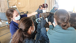
Wildlife veterinarians document the bear’s injuries prior to treatment.

veterinarian applying talapia skin on the bottom of burned bear paw
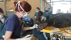
Burn treatment protocol includes the use of sterilized fish skins as a natural bandage for damaged tissue.

veterinarian team working on a mountain lion burned in fires in the lab
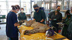
Wildlife veterinarians assess a mountain lion that was burned in the Bobcat Fire.

burned paw of a mountain lion
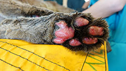
The burned paw pad of a mountain lion found in the wake of the Bobcat Fire.

In early December 2017, wildlife veterinarians from the UC Davis School of Veterinary Medicine and CDFW teamed up to try to save the life of a black bear that sustained third-degree burns in Southern California’s Thomas Fire. The innovative treatment involved the use of tilapia skins as natural bandages for the bear’s paw pads while she recovered from her injuries at CDFW’s Wildlife Investigations Laboratory (WIL) in Rancho Cordova.

Before the month was out, two more victims of the Thomas Fire joined her – a second burned bear, and a young mountain lion. The fish skin treatments were successful and all three patients survived – the bears were released back to the wild, and the orphaned lion cub, which was deemed too young to survive on its own, was placed in a sanctuary. In August 2018, the Carr Fire near Redding sent a fourth burned ursine patient to the lab, which was again treated and successfully released.

The veterinary science was groundbreaking, and the opportunity so very exciting for the team involved, especially the project’s leads, UC Davis’s Dr. Jamie Peyton and CDFW’s Dr. Deana Clifford.

Unfortunately, these four cases were just the beginning, with additional wild animals being burned in the Carr and Camp fires. The 2020 fire season in California has been even more severe, with more than 7,700 individual fires consuming 3.7 million acres of wildlife habitat so far. On Sept. 11, the WIL received its first burn patient of 2020, a 370-lb. male black bear from the aptly named Bear Fire (which later became the North Complex Fire) in Butte County. On Sept. 21, the second patient, a female mountain lion from the Bobcat Fire in Los Angeles County, arrived. On Sept. 30, a 520-lb. male bear was brought in from the Zogg Fire in Shasta County.

“Both bears and the lion are receiving our burn protocol, including the fish skin bandages, and we are optimistic that their burns will heal so that they can be released,” Dr. Clifford said. “But it’s likely that we will receive more wildlife with burns … we are only halfway through the regular fire season.”

As California’s wildfires grow in intensity, size and frequency, our state’s wildlife veterinarians are being forced to reexamine the big picture -- how wildlife are faring, to what extent we should intervene and what our capacity is to do so.

“While we know what a devastating effect wildfires have on our human population – and, to a lesser degree, domestic animals – our knowledge about how wildfires affect wildlife (non-domestic animals) during and immediately after the disaster has been so limited,” Dr. Peyton said. “There’s always been this prevailing mindset that ‘they’ll get out of the way,’ or that they can manage if left alone, but that needs to change. With the increase in frequency and severity of disasters, wildlife cannot escape. Without human interference, these animals will suffer and succumb, due not only to their injuries but also to the loss of food, water and habitat. It is our obligation to provide the missing link for the wildlife that share our home.”

A successful response to this developing need will require resources – time, money, and professional expertise. In an effort to build these resources quickly and efficiently, CDFW and the UC Davis School of Veterinary Medicine have drawn up a proposal for a wildlife search and rescue, field triage, transport and long term rehabilitation care system for injured wildlife resulting from wildfires.

The Wildlife Disaster Network, as it’s been dubbed, is modeled after the Oiled Wildlife Care Network (OWCN) – a similar structure created in 1994 to mobilize volunteers and professionals to help save shorebirds and other wildlife that are injured during coastal and inland oil spills.

The new Wildlife Disaster Network will include veterinarians, wildlife biologists, ecologists, trained animal care volunteers and rehabilitation centers that follow the four core principles already set by the OWCN: readiness, response, research and reaching out. There will also be field reconnaissance in the aftermath of fires, conducted by UC Davis-affiliated staff, with the approval and oversight of Incident Command, when conditions are deemed safe to do so. In addition, they have established a hotline for first responders, utility workers, and the general public to call in for assistance with coordinating care for injured wildlife: 1 (800) 942-6459 (1-800 WHC-OIL-9).

“The idea is to create a collaborative process – which works within any existing emergency incident command structure – that brings experts together to respond to injured animals and prevent suffering,” Dr. Clifford said.

In addition to easing the suffering of animals that are trapped by wildfires in California’s changing climate, the vets hope that the Wildlife Disaster Network will allow for California’s wildlife veterinarians and disaster response professionals to add to their knowledge, and promote further collaboration with others to share this knowledge. The long-term impacts on wildlife from these massive disasters are also largely unknown and in critical need of further investigation and intervention, especially in areas with threatened species. All of the data collected by the participants of the Wildlife Disaster Network – such as necropsy reports on the animals who do not survive their injuries – will help build a framework of scientific knowledge that didn’t previously exist.

Initially, equipment used in this effort will be loaned on an as-needed basis by the OWCN and CDFW. Ongoing financial support for this effort will be through fundraising from private donors via a gift fund to be established by UC Davis.

“These animals in need of care are a visible, tangible and poignant reminder that climate-changed induced wildfires are impacting our wildlife and ecosystems,” said Dr. Clifford. “They remind us that each of us should continue efforts to reduce the impacts of climate change.”

Donations to the Wildlife Disaster Network can be given online at the link opens in new windowCalifornia Wildlife Conservation General Support website or by calling the UC Davis School of Veterinary Medicine, Office of Advancement, at (530) 752-7024.

###

Media Contact:
Kirsten Macintyre, CDFW Communications, (916) 804-1714

CDFW photos

Categories: Science Spotlight
  • September 22, 2020

Paddleboarder enjoys Upper Newport Bay

groups on people on two kayaks on the ocean in Newport Bay with mountains and blue sky
Boaters in Upper Newport Bay

ocean fish in the Newport Bay
Fish at Back Bay Science Center

blue ocean water in the Newport Bay with mountains and blue sky
Upper Newport Bay, looking upstream

When you learn there’s a popular piece of property on the Southern California coast taking up more than 750 acres, you wouldn’t be faulted for imagining a marina, a golf course, a resort – or all three.

But one piece of land and (mostly) water is important and popular for what hasn’t been built there. The Upper Newport Bay Ecological Reserve showcases the beautiful California coast, unspoiled and filled with wildlife, plants and fabulous scenery.

The reserve is one of 749 properties carefully managed by the California Department of Fish and Wildlife (CDFW). Located in the heart of Newport Beach, in Orange County, the reserve is completely surrounded by some of the most highly valued real estate in the country. The University of California, Irvine, isn’t far away – neither is John Wayne Airport. But that’s all forgotten when exploring the reserve on foot, by boat or paddleboard, or with binoculars.

“People don’t realize how few areas exist like this anymore in Southern California, or that we have marshes in California. It’s not what people think of about the California coast; they think of beaches,” said Reserve Manager Dr. Amanda Swanson. “People can live one city over and not know this even exists.”

The reserve was created in 1975, at a time when developers most certainly would have jumped at the chance to turn this area into a profitable commercial property of some sort. Instead, it offers peaceful and scenic experiences for people looking to hike, fish, watch birds or view tidepools. Of equal importance, the reserve plays a large role in protecting wildlife and vegetation that isn’t as plentiful today as it once was.

“The reason this is so heavily protected – and why it’s a reserve now – is because we have a lot of really sensitive wildlife and vegetation here,” Swanson said. “We’ve lost 85 to 90 percent of our coastal wetlands in Southern California, and it’s one of the few large ones we have left. For that reason, unfortunately, we have multiple endangered species.”

Specific endangered plants on the reserve include salt marsh bird’s beak, while several bird species – Ridgway’s rail, Belding’s savannah sparrow, Least bell’s vireo, coastal California gnatcatcher and cactus wren – are either endangered or threatened.

The reserve offers an outstanding educational opportunity as well, with the presence of the Back Bay Science Center. CDFW partners with the city of Newport Beach, Orange County, the Newport Bay Conservancy and UC Irvine in operating the Science Center, which serves as a teaching and research facility at the reserve. Thousands of students, middle school age through college, visit the Center each year to learn about watershed and ecological concepts, habitat restoration and marine life. There’s no shortage of available lessons for anyone who visits the science center or reserve. (Due to COVID-19, the reserve is temporarily closed. Information on at-home programs and resources at the Science Center is available at link opens in new windowbackbaysciencecenter.org.)

“Coastal wetlands like Upper Newport Bay can provide several ecosystem services such as coastal protection from storms and flood protection. Then there’s filtration – we unfortunately have trash come down the watershed, so the wetlands can prevent some of that trash from making its way into the ocean, which gives us the opportunity to remove it,” Swanson said. “Wetlands also effectively cycle nutrients through processes that purify the water and store carbon in the soil.”

Changes in the carbon cycle are of particular concern as increased atmospheric CO2 is a contributor to climate change, added Swanson. The plants in coastal wetlands contribute to the carbon cycle because they consume and transform atmospheric CO2 through photosynthesis. When these plants die, they then transfer the carbon to the soil where it can be stored for long periods of time.

CDFW Senior Environmental Scientist Robin Madrid emphasized the important restoration work being done at the reserve for an aquatic plant called eelgrass. That work is being done by CDFW staff along with Orange County Coast Keeper, volunteers and California State University, Fullerton.

“Eelgrass provides a number of important ecosystem functions, including foraging areas and shelter to young fish and invertebrates, food for migratory waterfowl and sea turtles, and stabilizing sediment,” said Madrid.

Other restoration projects are also in progress to establish more suitable habitat for wildlife and to provide Upper Newport Bay with some resiliency to sea level rise. Completing the Big Canyon Restoration and Adaptation Project has been a goal of the City of Newport Beach and CDFW for several years. The second phase of the project is beginning this fall and will remove several acres of invasive Brazilian peppertrees, restore the hydrology and establish a mosaic of native wetland and transitional upland habitats. The design for the final phase of the project will also begin this fall. The project’s ongoing success can be attributed to the strong collaborative efforts between the landowners, local stakeholders and nonprofits.

With so much scientific work going on at the Upper Newport Bay Ecological Reserve, Swanson and her staff are careful not to lose track of the impacts on young visitors who might be seeing the marshes, mudflats and marine habitats for the very first time.

“It’s been surprising and impressive to me, that there’s such a great interest in bringing kids, especially those from disadvantaged communities, here to learn. Many of them aren’t often able to get out to the beach, so this is a fun and unique opportunity. They see the wildlife and their lives can be changed,” said Swanson.

Swanson recalls presenting to a group of fifth graders participating in the Newport Bay Conservancy’s Fostering Interest in Nature program. “I was so impressed with the kids I met and their enthusiasm for learning about the plants and animals on the reserve. Seeing their excitement and appreciation for nature has been one of my most rewarding experiences.”

link opens in new windowVIDEO: Upper Newport Bay Ecological Reserve and Back Bay

Media Contact:

Tim Daly, CDFW Communications (916) 201-2958

CDFW photos

Categories: Science Spotlight
  • September 18, 2020

The summer 2020 issue of the link opens in new windowCalifornia Fish and Wildlife Journal (PDF) is now online! This issue contains a number of excellent articles, including a couple on taxonomic groups that are often under-represented in the Journal — invertebrates and raptors.

Raptors can provide a benefit to agriculture by reducing rodent populations, yet many croplands and pastures do not provide adequate perching structures needed by raptors to hunt effectively. In link opens in new windowA novel method using camera traps to record effectiveness of artificial perches for raptors (PDF), Clucas et. al report on a new method that allows for 24-hour monitoring of artificial perch utilization. The resulting high-resolution photos capture a variety of raptors landing, perching, and consuming prey. The authors report that their method can be easily used to study the effectiveness of hunting perches for raptors in agricultural areas.

In link opens in new windowNotes on reproduction of Cascades frogs from California (PDF), Dr. Stephen Goldberg tackles the challenge of studying a nearly extinct species without collecting or euthanizing individuals. Using museum samples of 36 R. cascadae collected from 1954 to 1972 in Plumas County, Goldberg is able to gather and analyze tissue samples that document the timing of events in the frogs’ reproductive cycle. This data will prove useful in subsequent attempts to reestablish the species in its former range.

Longcore et. al examines the habitats of another species in decline. link opens in new windowNearly all California monarch overwintering groves require non-native trees (PDF) provides a thoughtful analysis of a conservationist’s paradox: the critical need to preserve exotic trees—namely eucalyptus—to protect the preferred overwintering habitat of this iconic butterfly species.

Dr. David Boughton provides a literature review of the striped bass in coastal California—a non-native species introduced in California in the late 1800s for sport fishing. link opens in new windowStriped Bass on the coast of California: a review (PDF) addresses three key questions: Where do Striped Bass occur on the California coast? (2) Do they comprise locally reproducing populations, strays from the Golden Gate, or both? and (3) What is the general scale or scope of their potential impact on coastal salmonid populations?

Finally, Dr. Vernon C. Bleich (a past editor of the Journal) describes the presence of a species in an area that has not been previously reported in the scientific literature. link opens in new windowLocality records for Woodhouse’s toad: have wet washes in a dry desert led to extralimital occurrences of an adaptable anuran? (PDF) details the presence of Woodhouse’s toad in the Santa Rosa Mountains on the western edge of the Coachella Valley, and discusses the probable role of extreme weather events in expanding the geographic range of A. woodhousii in southeastern California.

As it has for the past 105 years, our scientific journal – previously known as California Fish and Game – continues to publish high-quality, peer-reviewed science that contributes to the understanding and conservation of California’s wildlife. For more information and other back issues, please visit CDFW’s website.

###

CDFW Photo

Categories: Science Spotlight
  • August 28, 2020

VegCAMP staff researching at Carrizo Plain, San Luis Obispo County

Three scientist standing on dry grass with mountains and blue sky
VegCAMP staff working at Modoc Plateau, Modoc County

Smoke from a smoldering fire in a dry field with mountains and clouds in the sky
Lightning-caused fire witnessed by staff, Mono County

map of Slinkard Valley Wildlife Area fire scale vegetation
Slinkard Valley Wildlife Area vegetation map

California is home to more than 6,500 plant species, which offer sustenance and shelter to more than 1,000 animal species (this figure doesn’t include invertebrates).

In fact, part of the mission of the California Department of Fish and Wildlife (CDFW) is to manage the habitats upon which our fish and wildlife species depend. The cornerstone of those management efforts is knowledge of the plant assemblages that are unique to each habitat – where these natural communities are located, how prevalent (or rare) they are, and monitoring how their distribution may shrink or grow over time.

CDFW has three vegetation ecologists (Rachelle Boul, Betsy Bultema and Jaime Ratchford), a geographic information systems (GIS) specialist (Rosie Yacoub) and a unit supervisor (Diana Hickson) dedicated to exactly that task. Known as the Vegetation Classification and Mapping Program (VegCAMP), this team works year-round to identify, record and map all of the natural communities (also known as vegetation types) that grow in California’s 163,000 square miles. VegCAMP also relies on the mapping expertise of four contracted employees, paid through an arrangement with California State University, Chico.

According to Hickson, having a complete, reliable map of California’s vegetation is an invaluable scientific tool. “We need knowledge of where the vegetation is in order to make good management decisions, such as determining the best place to put a preserve, for example,” she says.

VegCAMP tackles this task by sampling, classifying, defining, naming and mapping the natural communities of an area – such as the Suisun Marsh, Point Reyes, Western Riverside County or the Mojave Desert. Some mapping areas encompass an entire eco-region (the Mojave Desert mapping area, for example) while some are as small as a 2,000-acre ecological reserve.
The process of classifying and mapping a CDFW property, for example, generally requires eight to 10 people to survey the property, taking detailed notes and pictures to describe the vegetation at different locations. The “boots on the ground” effort doesn’t have to cover every square inch, fortunately. The process requires collecting vegetation samples from a small portion of the mapping area (depending on the complexity), then extrapolating to determine the most likely makeup of the entire area. The data is then brought back to the office to be classified, and each location visited can be given a vegetation name. These locations on the ground are compared to aerial imagery and lines are drawn around each community type and labeled. Another measure of checks and balances is to have a second field crew survey known locations of each community, without having knowledge of the previously mapped attributes.

All of this information is entered into the VegCAMP database, where classification software and GIS tools allow users to gain a tremendous understanding of what comprises a particular area. “One map contains many different attributes,” Hickson explains. “For example, we can query the polygons (each mapped ‘patch’) to show acreage of conifer types, and then we can narrow the search to those conifer types that are tall or short, those that are regenerating or those that have a shrub layer under them. That’s the power of GIS layers.”

The data collected and recorded by the VegCAMP team has far-reaching implications, and is used by other agencies, nonprofits and partners as well.

Seeing the practical application of their work is a satisfying payoff for Hickson and her crew. For example, the VegCAMP team spent several years meticulously mapping Mendocino County’s Pygmy Forest, which is dominated by a few conifer species that grow to a height of six feet or less, due to nutrient-poor soil that saturates in the winter and dries completely over the summer. Over time, the team produced a comprehensive map that showed how much vegetation had been lost to residential development and cannabis grows, as well has how much remained. 

“As a result of our mapping, the county recognized the need to require more environmental assessment for proposals for development in that habitat,” Hickson explained. “It’s raised awareness of the vulnerability of that vegetation type.”

Vegetation ecologist Rachelle Boul also finds satisfaction in her work with VegCAMP. Her mapping efforts have largely been focused in the Suisun Marsh area in Solano County. This highly managed area is home to rare species such as the salt marsh harvest mouse, and CDFW works with the California Department of Water Resources and private duck clubs to maintain habitat for them while also allowing access for duck hunting. Here, VegCAMP remapped the vegetation every three years in order to determine if there had been any negative impact.

Boul noted the importance of aerial images, including those taken by satellite – VegCAMP has access to the photos taken by the US Department of Agriculture’s National Agriculture Imagery Program – and drones. “You can only make a vegetation map as good as the imagery that you interpret from. It’s just made it so much easier to be more accurate and more fine scale,” she said.
Boul says that it’s the diversity of her duties – from field work to data analysis to mapping vegetation and finally sharing that data with CDFW partners – that keeps her motivated and passionate about her job.

Being able to spend time in nature is certainly a perk for the VegCAMP ecologists but that’s not to say there aren’t job-related hazards. Both Hickson and Boul remember a particularly harrowing day in August 2017, when they were field mapping the Slinkard/Little Antelope Wildlife Area in Mono County, and a lightning strike touched off a fire. The VegCAMP team reported the fire immediately and were soon joined by CalFIRE helicopters and ground crews. Map-making took a back seat that day to field safety and group communication.

Despite the size and length of the fire (nearly 9,000 acres and several days), it didn’t really impact the work of VegCAMP. Nerves may have been rattled, but fortunately nearly all of that mapping area (work still in draft form) was untouched by flames.

###

Media Contact:
Tim Daly, CDFW Communications, (916) 201-2958

(CDFW Photos)

Categories: Science Spotlight
CDFW Science Institute logo

Subscribe

Receive Science Institute news by email.