Science Spotlight

Subscribe

Receive Science Institute news by email.

    All Science Spotlight Articles

    rss

    VegCAMP staff researching at Carrizo Plain, San Luis Obispo County
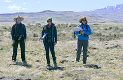
    Three scientist standing on dry grass with mountains and blue sky
    VegCAMP staff working at Modoc Plateau, Modoc County
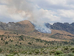
    Smoke from a smoldering fire in a dry field with mountains and clouds in the sky
    Lightning-caused fire witnessed by staff, Mono County
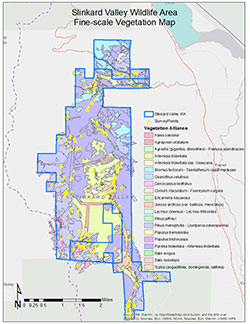
    map of Slinkard Valley Wildlife Area fire scale vegetation
    Slinkard Valley Wildlife Area vegetation map

    California is home to more than 6,500 plant species, which offer sustenance and shelter to more than 1,000 animal species (this figure doesn’t include invertebrates).

    In fact, part of the mission of the California Department of Fish and Wildlife (CDFW) is to manage the habitats upon which our fish and wildlife species depend. The cornerstone of those management efforts is knowledge of the plant assemblages that are unique to each habitat – where these natural communities are located, how prevalent (or rare) they are, and monitoring how their distribution may shrink or grow over time.

    CDFW has three vegetation ecologists (Rachelle Boul, Betsy Bultema and Jaime Ratchford), a geographic information systems (GIS) specialist (Rosie Yacoub) and a unit supervisor (Diana Hickson) dedicated to exactly that task. Known as the Vegetation Classification and Mapping Program (VegCAMP), this team works year-round to identify, record and map all of the natural communities (also known as vegetation types) that grow in California’s 163,000 square miles. VegCAMP also relies on the mapping expertise of four contracted employees, paid through an arrangement with California State University, Chico.

    According to Hickson, having a complete, reliable map of California’s vegetation is an invaluable scientific tool. “We need knowledge of where the vegetation is in order to make good management decisions, such as determining the best place to put a preserve, for example,” she says.

    VegCAMP tackles this task by sampling, classifying, defining, naming and mapping the natural communities of an area – such as the Suisun Marsh, Point Reyes, Western Riverside County or the Mojave Desert. Some mapping areas encompass an entire eco-region (the Mojave Desert mapping area, for example) while some are as small as a 2,000-acre ecological reserve.
    The process of classifying and mapping a CDFW property, for example, generally requires eight to 10 people to survey the property, taking detailed notes and pictures to describe the vegetation at different locations. The “boots on the ground” effort doesn’t have to cover every square inch, fortunately. The process requires collecting vegetation samples from a small portion of the mapping area (depending on the complexity), then extrapolating to determine the most likely makeup of the entire area. The data is then brought back to the office to be classified, and each location visited can be given a vegetation name. These locations on the ground are compared to aerial imagery and lines are drawn around each community type and labeled. Another measure of checks and balances is to have a second field crew survey known locations of each community, without having knowledge of the previously mapped attributes.

    All of this information is entered into the VegCAMP database, where classification software and GIS tools allow users to gain a tremendous understanding of what comprises a particular area. “One map contains many different attributes,” Hickson explains. “For example, we can query the polygons (each mapped ‘patch’) to show acreage of conifer types, and then we can narrow the search to those conifer types that are tall or short, those that are regenerating or those that have a shrub layer under them. That’s the power of GIS layers.”

    The data collected and recorded by the VegCAMP team has far-reaching implications, and is used by other agencies, nonprofits and partners as well.

    Seeing the practical application of their work is a satisfying payoff for Hickson and her crew. For example, the VegCAMP team spent several years meticulously mapping Mendocino County’s Pygmy Forest, which is dominated by a few conifer species that grow to a height of six feet or less, due to nutrient-poor soil that saturates in the winter and dries completely over the summer. Over time, the team produced a comprehensive map that showed how much vegetation had been lost to residential development and cannabis grows, as well has how much remained. 

    “As a result of our mapping, the county recognized the need to require more environmental assessment for proposals for development in that habitat,” Hickson explained. “It’s raised awareness of the vulnerability of that vegetation type.”

    Vegetation ecologist Rachelle Boul also finds satisfaction in her work with VegCAMP. Her mapping efforts have largely been focused in the Suisun Marsh area in Solano County. This highly managed area is home to rare species such as the salt marsh harvest mouse, and CDFW works with the California Department of Water Resources and private duck clubs to maintain habitat for them while also allowing access for duck hunting. Here, VegCAMP remapped the vegetation every three years in order to determine if there had been any negative impact.

    Boul noted the importance of aerial images, including those taken by satellite – VegCAMP has access to the photos taken by the US Department of Agriculture’s National Agriculture Imagery Program – and drones. “You can only make a vegetation map as good as the imagery that you interpret from. It’s just made it so much easier to be more accurate and more fine scale,” she said.
    Boul says that it’s the diversity of her duties – from field work to data analysis to mapping vegetation and finally sharing that data with CDFW partners – that keeps her motivated and passionate about her job.

    Being able to spend time in nature is certainly a perk for the VegCAMP ecologists but that’s not to say there aren’t job-related hazards. Both Hickson and Boul remember a particularly harrowing day in August 2017, when they were field mapping the Slinkard/Little Antelope Wildlife Area in Mono County, and a lightning strike touched off a fire. The VegCAMP team reported the fire immediately and were soon joined by CalFIRE helicopters and ground crews. Map-making took a back seat that day to field safety and group communication.

    Despite the size and length of the fire (nearly 9,000 acres and several days), it didn’t really impact the work of VegCAMP. Nerves may have been rattled, but fortunately nearly all of that mapping area (work still in draft form) was untouched by flames.

    ###

    Media Contact:
    Tim Daly, CDFW Communications, (916) 201-2958

    (CDFW Photos)

    Categories:   Science Spotlight

    bear in a tree with a tracking collar with the sun rays shining through the trees
    A collared bear near Blue Canyon in Placer County.

    For years, California Department of Fish and Wildlife scientists were trying to locate dens for California’s Sierra Nevada red fox — a rare and threatened species whose population has decreased substantially. Scientists had a general idea that some of the foxes denned at high elevations in the Lassen Peak area, but aside from vague descriptions written in the 1920s, the den locations had never been documented.

    In 2018, a team of scientists led by CDFW wildlife biologist Jennifer Carlson put GPS satellite collars on several Sierra Nevada Red Foxes. They were able to locate several dens in 2018 and 2019 and are in the process of verifying at least two more. Through collar technology and field work they have also verified that the population they were tracking has successfully raised litters.

    “Knowing basic information about where the foxes live and breed will help us develop conservation actions to benefit the species,” said Pete Figura, a CDFW wildlife management supervisor who has experience collaring many types of wildlife including deer, elk, Pacific fishers and band-tailed pigeons.

    The conservation benefits of collar technology have been well documented. Perhaps slightly less well known is that collars are designed and deployed with animal welfare in mind, allowing study animals to reproduce, get the food they need, maintain a healthy weight and live full lives.

    Scientists strive to use collars that weigh five percent or less of an animal’s body weight, and in some cases can use collars that weigh as little as one-and-a-half percent of an animal’s body weight. When possible, scientists use collars that feature a drop-off mechanism which releases the collar before its battery life runs out. The drop-off mechanism also ensures that the animal does not have to live the remainder of its life with an inactive collar. Drop-off collar technology isn’t yet available on some of the smallest collars but may be in the future. Biologists also use expandable collars for young animals that haven’t reached full size, allowing them to grow without being impeded by the collar.

    CDFW uses collars that provide two types of telemetry data. The data is derived from three basic approaches:

    1. Collars that send out a VHF radio signal which researchers can detect or listen to with an antenna to determine an animal’s general location and whether it is alive or dead. Researchers must be relatively close to detect the VHF signal.
    2. Collars that passively receive a radio signal from satellites and collect GPS location and other data such as movement and temperature. The data are usually stored onboard the unit which needs to be retrieved and downloaded onto a computer. Some of these collars also allow researchers to download data remotely using a hand-held device, but researchers must be relatively close to the animal. These collars also incorporate the VHF radio signal technology described above.
    3. Collars that also communicate actively to satellites allowing researchers to access location data on their computers and communicate with the collars to change settings remotely (e.g., to change the data collection schedule during migration).

    While CDFW collars many types of animals, ungulates (hooved mammals) are the largest group. At any given time, CDFW is collecting data from 500 or more collared ungulates across the state including deer, elk, pronghorn and bighorn sheep. The department collects data on collared ungulates for conservation purposes and to inform hunting limits. Scientists track movement, habitat use and survival and can collect data on everything from ambient temperature to the direction and speed the animal is traveling. Collars can also tell scientists when and where an animal has died and whether it is moving, feeding, or resting.

    “We take very seriously our ethical obligation not to harm animals or unnecessarily cause them discomfort. We take great strides to ensure collars have the right fit and weight for the animal wearing them,” said David Casady, a CDFW wildlife biologist with extensive collaring experience.

    Collars are typically made from foam and leather with a circuit board housed in strong metal or plastic casing. For data purposes, collars are designed so that the animal doesn’t behave differently than the rest of the population.

    “The data we collect from a collared animal needs to be representative of the population at large or it’s not very applicable to our management and conservation efforts,” said Casady.

    Data from collars allow CDFW to make well-informed, science-based management decisions. Although scientists in the field often have a solid understanding of the wildlife they research, thoroughly vetted data is what counts in the eyes of decision makers.

    Wildlife Biologist Justin Dellinger researches mountain lions (and wolves) for CDFW. He’s seen valuable data come from the 70 to 80 collared lions currently being monitored throughout the state.

    “With collared males that move around and look for new territory, data can show us where there’s a lack of habitat connectivity. We can use those data in developing movement corridors and road crossings. It can ultimately help our state’s lion population live full lives,” he said.

    Dellinger can also attest to the fact that collared lions are able to reproduce. “A 10-year-old female collared lion that we’re monitoring recently had her fifth litter of kittens,” he said.

    ###

    CDFW Photos. Top Photo: A collared deer at Bonita Meadows in Tulare County in 2017. The deer was collared as part of a long-term monitoring project.

    Media Contact:
    Ken Paglia, CDFW Communications, (916) 825-7120

    Categories:   Science Spotlight

    aerial view of a dirt road with a river running through a low area with blue skies in the background
    Drone images helped document damages and clean-up during the 2019 oil spill at Cymric Oil Field near Bakersfield

    five scientist in an open field with a target to take off and land the drone with snow capped mountains and blue sky in background
    CDFW drone pilots use foldable landing pads that work on multiple surface types—here during a drone mission in Inyo County

    In March 2019, there was late winter flooding at the Yolo Bypass Wildlife Area in Yolo County near Davis. Wildlife area supervisor Joe Hobbs wanted to check a series of old railroad trestle mounds to make sure there was no wildlife stranded there. In previous years when there had been flooding, staff went out on a boat to check the trestle mounds. But that approach had downsides: From a boat, it could be difficult to see exactly what was on the mounds, and the sound of the boat’s motor could potentially spook the animals.

    Hobbs saw an opportunity to utilize the California Department of Fish and Wildlife’s (CDFW) drone program, a service offered by CDFW’s Geographic Information Systems (GIS) Unit within the Biogeographic Data Branch. He submitted a project request which was ultimately granted.

    Drone footage showed two deer on one of the trestle mounds. A CDFW biologist did an assessment and concluded that the water was receding quickly, and the deer were not at risk of being stranded.

    “The drone was a great tool for getting the information we needed without causing stress to wildlife,” said Hobbs. “It was quiet and safe and gave us a view of the trestle mounds that we couldn’t get from the ground or in a boat.”

    CDFW’s drone program got its start in the early 2010s as GIS Program Manager Steve Goldman and others on the GIS team saw the technology becoming more affordable and useful. In 2014, Goldman put together a dedicated team within the GIS Unit to research policy and best practices. The program officially launched in 2016 when it received its Federal Aviation Administration authorization to fly.

    “Drones are very useful for natural resource management because they provide high-resolution aerial imagery and documentation of conditions on the ground in a timely, safe and cost-effective manner that is repeatable,” said Goldman, who also serves as CDFW’s Unmanned Aircraft System (UAS) Coordinator.

    Here are a few examples of CDFW drone missions:

    • In 2017, a drone was used to help scientists conduct a bighorn sheep population count outside of Bishop in Inyo County
    • Drone footage helped scientists survey portions of the America River in 2016 to find salmon redds, nests created by salmon in riverbeds where females lay their eggs.
    • As a permitting agency for legal cannabis grows in California, CDFW advises property owners on how to mitigate environmental damage. In 2019, the department used drone footage to assist the buyer of a cannabis property with assessing erosion damage caused by the previous property owner.
    • CDFW has historically partnered with other agencies to do pelican population counts using airplanes over the Tule Lake Wildlife Refuge, a national refuge near the Oregon border. In 2018, CDFW experimented with doing counts using drones to see if results could be achieved more safely and efficiently. Staff found that drones took higher quality images and could potentially yield more accurate counts. Staff also used the mission to assess the disturbance effect of drones and found no disturbance to wildlife.
    • CDFW’s Office of Spill Prevention and Response (OSPR) used drone footage in 2019 to document clean-up efforts in the nearly 800,000-gallon oil spill at Cymric Oil Field near Bakersfield. In March 2020, OSPR utilized drone footage to document clean-up efforts at a tanker truck spill in the Cuyama River in Santa Barbara County.

    Because CDFW’s mission is managing the state’s natural resources, the drone program puts considerable focus on minimizing the risk of wildlife disturbance. Before each mission, program staff consult with a biologist to assess the risk of disturbance. If there is any appreciable risk, a biologist accompanies staff on the mission to serve as a wildlife observer. CDFW’s drone program also has a working group to research and catalog disturbance effects by wildlife species. The group’s goal is to minimize wildlife disturbances and develop best practices.

    CDFW drone pilots have been fortunate enough to not have any major conflicts with wildlife. But there was one close call. In 2018, while on a training flight at the Yolo Bypass Wildlife Area, a raptor appeared to take interest in the drone. In these situations, pilots are trained to ascend above the bird to get away. Drones can ascend faster than birds of prey can and descend rather slowly.

    “The pilot noticed the raptor’s interest early, and at one point the raptor started to come at the drone. The pilot did exactly what he was trained to do – he ascended and got out of the raptor’s way. It wasn’t a dramatic incident, but it did validate our procedures and protocol,” said Goldman.

    CDFW has a fleet of 25 drones flown by 14 certified pilots. Additionally, 20 staff are working toward their drone certifications. The current growth is primarily within OSPR and within the Cannabis Lands Program. Certified staff flew 100 missions in 2019. Since the program’s launch, staff have amassed more than 1,800 flights and 300 plus hours of airtime.

    “We think we’ve only started to skim the surface of what’s possible with drones. We are excited to continue working with staff to find those opportunities to support our mission,” said Goldman.

    Only staff certified through the CDFW’s UAS program are authorized to operate a drone for department work. No personal drones may be used for department work.

    ### 

    CDFW Photos. Top Photo: Image from a drone mission at Sheepy Lake in Siskiyou County

    Media Contact:
    Ken Paglia, CDFW Communications, (916) 825-7120

    Categories:   Science Spotlight