Science Spotlight

rss
  • April 24, 2018


Man in Department of Fish and Wildlife uniform on coastal cliff with succulent plant in hand
Wildlife Officer Pat Freeling replanting dudleya.

Man in Department of Fish and Wildlife uniform on vegetation covered cliffside with hand on succulent plant
Wildlife Officer Will Castillo replanting dudleya.

Last week, a team of California Department of Fish and Wildlife (CDFW) staff and volunteers spent hours working to replant than 2,000 Dudleya succulents that were seized after a poaching investigation. The plants were meticulously returned to the Mendocino and Humboldt county cliffs from where they were stolen weeks before.

The sheer volume of plants made it necessary to put a call out for help from volunteer botanists. The response was overwhelming. More than 20 succulent experts from the California Native Plant Society and U.C. Santa Cruz arboretum, along with National Parks Service personnel, assisted CDFW wildlife officers and seven environmental scientists on the replanting project. The replanted succulents will be monitored over the next week to ensure the greatest chance for survival.

CDFW Environmental Scientist Michael van Hattem calls Dudleya “the botanical version of abalone,” in the sense that they are a sensitive species, dependent on a very specific habitat. Without a concerted effort to reverse the effects of such a large poaching operation, he says, the ecosystem would be irreversibly damaged.

In March 2018, CDFW law enforcement officers uncovered an international conspiracy to strip the succulents from sea cliffs and ship them overseas to other countries, including Korea and China, where they are prized for decorative purposes. So far, there have been three significant poaching investigations. In the first case, prosecuted in Mendocino County, the subject was found guilty and fined $5,000. A second case is also currently pending in Mendocino County. 

The link opens in new windowthird recent case was out of Humboldt County, where wildlife officers seized well over 2,000 succulent plants from three suspects. Prosecution of that case is also pending. This week, the Humboldt County District Attorney’s Office released all but 10 of the plants from evidence to allow the team to replant them at the location where taken. 

“Our wildlife officers and partners have gone to extraordinary length to investigate and stop a new poaching threat in California,” said David Bess, Deputy Director and Chief of the Law Enforcement Division. “We can't think of a better project to work on through Earth Day weekend.”

CDFW Photos. Top Photo: Wildlife Officer Will Castillo replanting a Dudleya succulent.

Categories: General
  • April 20, 2018

Man in Department of Fish and Wildlife uniform standing in the bed of a truck shoveling rocks

Man in Department of Fish and Wildlife uniform standing in stream pouring rocks into stream from large bucket

Man in Department of Fish and Wildlife uniform crouching in stream looking at the water

Stream with rocks lining the streambed

California’s drought emergency was officially declared to be over last year, but its deleterious impact on fish habitat is still being felt in many parts of the state -- especially in arid parts of Southern California. In order to help offset these effects at one site in northern San Diego County, CDFW biologists and other staff recently toiled to create spawning beds for rainbow trout.

The Sweetwater River is a second-order stream located within Cuyamaca Rancho State Park. The underlying rock is granite, which, as it erodes, creates sand that accumulates in the low-gradient portion of the river. Previous surveys in the Sweetwater River revealed a lack of high-quality spawning habitat for the rainbow trout population, which was reduced by 70 to 80 percent during the recent drought.

Seeing an opportunity to restore habitat to this waterway, South Coast Region fisheries biologists came up with a plan to place suitable materials into Sweetwater for the rainbow trout to use for new spawning grounds. Beginning on March 20, CDFW Environmental Scientist Russell Barabe, scientific aids Joseph Stanovich and Ken Sankary and volunteer Mark Berlin worked in the hot sun and dry conditions to rehab the streambed. Using a nearby dry stream channel, the team shoveled hundreds of pounds of rocks and materials through mesh screens to remove fine sediment and sand and clean the rock, called cobbles, to make them ready for placement into Sweetwater River. All the rock had to be moved one bucket at a time and poured into pool tailouts (the downstream end of a pool where the water gradually shallows) to create spawning beds about three feet square for rainbow trout.

Though similar work has been done in northern California – specifically two larger-scale projects in the American and Sacramento rivers, which served as the inspiration for this project – it had never been done in this small a stream before.

This small but important project could increase the spawning success of a drought-reduced population in a stream with easy public access. If successful, this project could be used as a model for future habitat restoration activities in other small trout streams. The fisheries team’s work is an example of how our scientists put the mission of CDFW – to conserve California’s fish and wildlife resources for the use and enjoyment of the public – into action.

CDFW Photos. Top Photo: CDFW Scientists hauling buckets of rocks to create spawning beds for rainbow trout.

# # #

Categories: General
  • April 12, 2018

CDFW wants to know if, when and where you’ve seen an elk in California – and they’ve just created a new online reporting tool that makes it easy for members of the public to share this information.

CDFW scientists will use the raw data to help guide their efforts to study statewide elk distribution, migration patterns and herd movement, population size estimates, habitat use, health and diseases, and causes of mortality.

“We have limited resources and our scientists cannot scan the entire landscape,” explained CDFW Senior Environmental Scientist Pete Figura. “This tool provides a way for us to leverage the many sightings of the wildlife-watching public. People often get excited when they see elk, and hopefully now they will channel that excitement by reporting the location and time of their sighting to our department.”

There are three subspecies of elk in the state – tule, Rocky Mountain and Roosevelt -- and all three have expanded their range in recent years according to Figura.

CDFW has elk studies underway in the northern part of the state: one is focused on Roosevelt elk in Humboldt and Del Norte counties, and the other is focused on elk in Siskiyou and Modoc counties. Tracking and studying such a large mammal is a complex undertaking as elk herds are wide-ranging, and often graze and browse in areas that are not easily accessible, and there are only so many scientists to monitor their movements.

The launch of the reporting tool is just the latest effort to enhance the management of elk in California. Last year CDFW released a public draft of the Statewide Elk Conservation and Management Plan that addresses historical and current geographic range, habitat conditions and trends, and major factors affecting elk in California.

The plan will provide guidance and direction for setting priorities for elk management efforts statewide. CDFW is reviewing public comments on the plan and will incorporate appropriate changes into the final document prior to its release, which is expected soon.

CDFW Wildlife Branch Chief Kari Lewis has termed the plan an “important milestone” and explained that public feedback is a critical part of shaping the effort, which emphasizes a sharing of resources and collaboration with all parties interested in elk and elk management. This, she said, is essential to effectively managing California’s elk populations.

For more information about elk in California, please visit CDFW’s elk management webpage.

CDFW File Photo. Top photo: Group of Tule Elk.

# # #

Categories: General
  • April 6, 2018

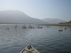
Bow of kayak floating on calm lake with foggy mountains in background
Brush habitats were created and put into Lake Perris to provide fish with habitat to feed and reproduce. The habitats will be completely submersed when the lake is filled to capacity.
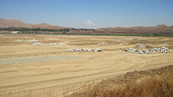
Barren earth with large piles of large rocks distributed throughout
The exposed lakebed gave CDFW fisheries biologists the opportunity to safely construct different kinds of habitat for the fish in Lake Perris.
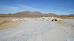
Landscape covered in gravel and piles of large rocks
Rock Reefs and Spawning gravel areas have been created and placed in more than 100 places around Lake Perris that will be utilized once the lake is returned to full capacity.
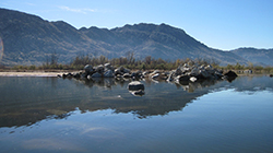
Calm lake facing a pile of large rocks partially submerged with mountains in the background
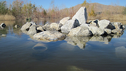
Rock Reefs constructed along the shore of Lake Perris, most about 1,000 square feet provide cover for juvenile fish and forage species.
Lake with partially submerged pile of rocks with trees and mountain in the background
135 Pipe Caves were constructed from PVC pipe and will provide spawning habitat for catfish.
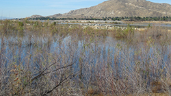
Landscape of lake with overgrown vegetation in foreground, land peninsula with piles of large rocks in midground, and trees and mountains in background
Biologists created about 1,500 brush habitats in hundreds of locations on the banks of Lake Perris and in accessible locations further into the lake.
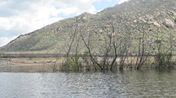
lake with partially submerged vegetation and mountain in the background
Biologists created about 1,500 brush habitats in hundreds of locations on the banks of Lake Perris and in accessible locations further into the lake.

More than a decade ago, Southern California freshwater anglers were disappointed to see a tried-and-true fishing spot dramatically affected by an emergency lake drawdown. Due to seismic concerns with the Perris Dam, California Department of Water Resources (DWR) officials deemed it necessary to reduce the water level at Lake Perris near Riverside by several thousands of acre-feet.

The drawdown exposed about 25 feet of bank around the perimeter of the lake. Since water was not going to be available for years while the dam was assessed and repaired, CDFW embarked upon a fisheries habitat mitigation project (funded by DWR) to create new fish habitat in the remaining water and the now exposed lakebed.

The project had two phases. The first was to immediately create fisheries habitat in the drawn-down portion of the lake in order to maximize use of the remaining water. The second was to build new habitats on the temporarily exposed areas, with the hope of benefitting both sport-fish species and anglers when the lake is eventually refilled. 

After 12 years, both phases are nearly completed.

After the initial water level reduction, teams from CDFW and DWR began working to prevent the immediate collapse of the lake’s fishery. The initial work, which took three years, involved the creation and placement of about 400 fish habitats made of recycled Christmas trees and citrus limbs. The man-made shelters ensured the fish would have places to hide and reproduce.

After the initial triage, CDFW biologists began to place additional habitats into the remaining water of Lake Perris. These habitats, made of thousands of tree trunks, citrus limbs and whole tree stumps would eventually give the lake’s fish an additional 1,500 refuges for safety. 

The citrus limbs were drilled with a ½” hole in the base and multiple limbs were tied together as compactly as possible and attached to a concrete block with polypropylene ropes to weigh them down. They were then placed strategically in different parts of the lake. These citrus habitats should provide cover for the warm water fish for at least 10 - 15 years.

Due to their bulk, increased buoyancy and weight, the single tree stumps were placed individually around the lake and weighted down with concrete blocks to keep them anchored.

Because the lake will be refilled to capacity once dam repairs are complete, it is important that the scientists are able to carefully track each habitat location. They worked in quadrants, placing 20 - 60 bundles into each to create “communities.” The grouped communities increase localized productivity of the warm water fish native to the lake and contribute to maintaining the warm water fisheries while the lake is in its reduced capacity. Each of the quadrant’s corners was marked with GPS, enabling scientists to record and monitor data specific to each location. 

The second phase of the project was the implementation of a Fishery Habitat Plan for the exposed lakebed above the drawn-down area. The implementation of the plan is a requirement of the Lake and Streambed Alteration Agreement between CDFW and DWR.

As with the below-water work that had already been completed, CDFW scientists carefully planned what kinds of habitat to create, what materials to use and where to place them in the open, exposed lakebed in order to provide the best environments for fish when the lake was fully restored. Areas were selected for habitat placement based on accessibility, proximity to existing natural habitat directly affected by the water reduction, avoidance of areas utilized for construction activities, distance from swimming areas and consideration of boating hazards.

Multiple types of habitats were designed and installed in Lake Perris, including:

  • Brush habitats. Similar to the citrus branch habitats already placed in phase one, these brush habitats add to the terrestrial vegetation growth that has thrived in the lakebed since initial triage efforts began in 2006.
  • Pipe caves constructed from 12” diameter PVC pipes. Approximately 4 feet long and capped at one end with concrete, these will provide spawning habitat for catfish that was lost when the lake was drawn down. A total of 135 pipe caves were placed around the rock reefs and terrestrial vegetation and will allow the young catfish to disperse into favored rearing habitat.
  • Rock reefs were created from 226 dump truck loads of material stockpiled by DWR from a nearby rock quarry. These rock piles cover about 110,000 square feet of the lakebed -- about the size of two football fields. Staff created 109 rock reefs, each about 1,000 square feet (about the size of an average home lot). These provide cover for juvenile fish and forage species (such as crayfish) as well as spawning habitat and foraging areas for adult fish. Their placement is designed to allow fish to transition from deeper waters to shallower waters -- and vice-versa -- when the lake returns to normal operating levels.
  • Spawning gravel areas. Thirty of these were created from suitable bottom composition for sunfish, bass, bluegill, etc. to spawn on and around. Almost 200,000 square feet of gravel bed habitat are now in the shallowest areas of the lake, adjacent to rock reefs or terrestrial vegetation that will be covered once the lake refills.

    After years of cooperative work Lake Perris is nearly ready to be refilled and with the thousands of new and improved habitats local anglers will be shouting “fish on” for decades to come. 

CDFW Photos. Top Photo: Citrus tree stumps, weighted down with concrete blocks to keep them anchored were placed individually around Lake Perris to create small habitats called communities.

# # #

Categories: General
  • April 5, 2018

The latest issue of California Fish and Game, the California Department of Fish and Wildlife’s scientific journal, is now available online! Issue 103(4) features articles that add to the knowledge base for three marine species, all of which face potential threats from overharvesting, incidental take and loss of habitat: Thorny stingray, Chinook salmon and green abalone. 

The link opens in new windowThorny stingray (Urotrygon rogersi) (PDF) is common in the eastern Pacific, from the Gulf of California south to Ecuador, and is frequently a by-catch of commercial shrimp trawlers. Little is known about its life history and movements. It was thought to occupy relatively shallow depths ranging from two to 15 meters, with a maximum recorded depth of 30 meters. In their published research, Acevedo-Cervantes et al. report the discovery of specimens at a depth of 235 meters—an indicator that the Thorny stingray has the capacity to survive beneath the disturbance of commercial shrimping activity. According to the authors, this new information is “of vital relevance” for the management of the species.

Adams et al. examined the effects of link opens in new windowEl Niño on adult Chinook salmon as they migrate through the Gulf of the Farallones (PDF). Researchers found that the dressed weight of commercial landed Chinook was lower during El Niño compared to non-El Niño years, a reduction attributed to a disruption in the normal feeding cycle in the Gulf of the Farallones. The analysis suggests that management agencies need to give more consideration to ocean conditions as risk factors in planning the recovery of endangered and at-risk Chinook salmon spawning runs.

link opens in new windowGreen abalone (Haliotis fulgens; Philippi) (PDF) were once part of a large recreational and commercial fishery, but are now estimated to be at less than 1% of their baseline density. Past attempts at restocking wild populations using juvenile farm-raised green abalone have resulted in high mortality rates. In “Outplanting large adult green abalone (Haliotis fulgens) as a strategy for population restoration,” author Caruso explores the efficacy of using adult specimens—at least 10 years old—to augment wild populations. The resulting 40 percent survival rate is much higher than the survival rates of previous projects that used juveniles. Although it is costly to raise green abalone to adult size, it may be the best method, given the decades of past unsuccessful restocking attempts.

These articles provide information useful to fisheries managers and should be helpful for future recovery efforts.

Cover photo © Peter Hemming

Categories: California Fish and Game Journal
CDFW Science Institute logo

Subscribe

Receive Science Institute news by email.