Science Spotlight

Subscribe

Receive Science Institute news by email.

    All Science Spotlight Articles

    rss

    Partial map of the State of California with area marked in black outline and covered in small black dots.
    CDFW scientists conducted a groundbreaking survey of lizards across the entire Mojave Desert. CDFW graphic.

    One might say that a groundbreaking new study conducted by two CDFW scientists and their research partners provides a leap forward in lizard research.

    Dr. Brett Furnas, a senior environmental scientist with CDFW’s Wildlife Investigations Lab, is the lead author on a paper entitled link opens in new tab or windowHierarchical distance sampling to estimate population sizes of common lizards across a desert ecoregion. The co-authors on this paper are Scott Newton and Griffin Capehart, both formerly contractors for the Wildlife Branch at CDFW, and Dr. Cameron Barrows with the Center for Conservation Biology at the University of California, Riverside.

    According to Furnas, monitoring programs that survey many wildlife species at the same time across large geographic regions are important for informing conservation decisions, but reptiles are often missing from these efforts because they are difficult to survey. Therefore, the researchers applied a new distance-sampling approach to more accurately count lizards across the entire Mojave Desert within California (25,803 square miles in total).

    “As far as we know, this is the first time a lizard population has been accurately enumerated over such a large area of desert,” said Furnas.

    Visual surveys of lizards were conducted in 2016 along quarter-mile long transects at 229 widely dispersed sites throughout the desert. The surveys were repeated several times during the same month, which allowed CDFW scientists to correct for lizards that were missed during any one visit due to hot weather and other factors. The researchers validated their results by comparing them against a different set of surveys conducted by Barrows over a much smaller area at Joshua Tree National Park.

    After using advanced statistical models to extrapolate survey results across the entire desert, CDFW estimated 82 million lizards for the three most common species of lizards across an area amounting to 16 percent of the total land area of the state. The population numbers reflect an average of 3,170 lizards per square mile.

    “Having a good measure of population size for any species is important because it allows us to make more effective conservation decisions when we know how abundant a species is, what habitats is uses, and whether it is increasing or declining in numbers,” Furnas said. “These are often the first questions decision-makers want answers to.”

    This is especially important in the deserts of California and the Southwestern United States, which are already experiencing severe increases in temperature and reductions in rainfall due to climate change. There is concern that these increases in temperature may already be exceeding the physiological limits of some lizard species, thereby increasing their risk of extinction. 

    “Lizards and other reptiles are particularly sensitive to temperature, in part because they are ‘ectothermic,’” explained Furnas. “Unlike mammals, reptiles cannot use their metabolism to regulate body temperature; instead they may need to take shelter on very hot days, which may limit the time they can spend foraging for food.”

    In addition to demonstrating the value of a new method for monitoring reptiles, the study was able to map the distribution of lizards throughout the Mojave Desert and show how population levels and the behavior of lizards vary with differences in vegetation cover, human land use, and temperature. Of the three species studied, Western Whiptail (Aspidoscelis tigris) and Common-side Blotched Lizard (Uta stansburiana) were more abundant in cooler places found at higher elevations or where there was greater vegetation cover. On the other hand, Zebra-tailed Lizard (Callisaurus draconoides) was more tolerant of high temperatures, but was the most sensitive to human development and disturbance.
    CDFW Photo and Graphic. Top Photo: This common side-blotched lizard (Uta stansburiana) was surveyed at Joshua Tree National Park. CDFW Photo by Cameron Barrow.

    ###

    Media Contacts:
    Kyle Orr, CDFW Communications, (916) 322-8958
    Brett Furnas, CDFW Wildlife Investigations Laboratory, (530) 227-3998  

    Categories:   Wildlife Research

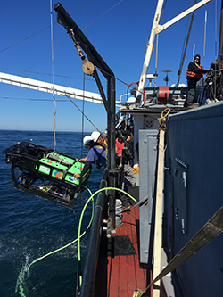
    Side of boat with two men wearing white hard hats leaning over the railing reaching for large black and green machine held up by a crane.
    The ROV Beagle (CDFW photo)
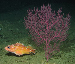
    Orange fish with very few white dots in dorsal region underwater next to large pinkish red sea plant
    Starry Rockfish from the Channel Islands (CDFW photo)
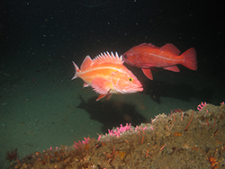
    Red and orange fish with spiny dorsal fin underwater. Red fish in background.
    Yelloweye and Vermilion rockfishes from the North Coast (CDFW photo)
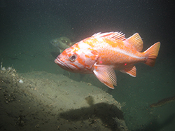
    Orange fish with white stripes across head and down body underwater.
    Canary Rockfish from the North Coast (CDFW photo)

    Gray speckled fish underwater on top of rock covered in round white anemone
    Lingcod, white-plumed anemones, female kelp greenling (CDFW photo)
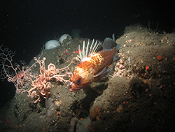
    Orange fish with thick white bands and spiny dorsal fin underwater over large rock covered in salmon pink creature with narrow, long spiraling limbs.
    Quillback Rockfish and Basket Stars from the North Coast (CDFW photo)

    Orange-pink creature shaped like a ball underwater with hundreds of long hair-thin extensions extended toward rock.
    Benthic siphophores use threads to walk and anchor to the seafloor (CDFW photo)

    Black and green machine with two yellow tanks on top above water, suspended by chain.
    ROV Beagle (CDFW photo by Michael Prall)

    Marine scientists from the California Department of Fish and Wildlife (CDFW) and Marine Applied Research and Exploration (MARE) recently completed an unprecedented three-year survey of deep-water habitats off the California coast using a remotely operated vehicle (ROV). Beginning in 2014, MARE’s ROV Beagle was deployed throughout the state to survey and record the species and types of habitats associated with marine protected areas (MPAs) and nearby, comparable rocky habitats.

    Surveys were video-based and provided a first look at the many recently established MPAs throughout the state and generated much needed data on abundance and distribution of fish species harvested from rocky habitats.

    According to Marine Environmental Scientist Mike Prall, “Many of the areas visited by the ROV Beagle during the surveys had probably never been directly observed by human eyes before our surveys. And all data gathered from video and still imagery collected during the expeditions have provided much needed information about California’s vast deep-water habitats.”

    This statewide survey was funded by a $1.9 million research grant awarded to CDFW in 2013 to survey underwater habitats from Mexico to the Oregon border using state-of-the-art underwater technology operated by MARE. In all, five deployments visited over 130 locations and collected hundreds of hours of video in standard and high definition formats, as well as over 50,000 digital still photographs.

    Working through MARE’s video processing laboratory in Eureka, trained technicians methodically characterized habitat and identified hundreds of species of fish and invertebrates from high definition video and still photography. Detailed information was also collected from the ROV’s path across the seafloor, which was then used to accurately identify the location of each observation. CDFW scientists used that data for future analysis of abundance, size estimates and patterns of distribution for important species, among other applications.

    Preliminary examination of observations from the first ROV deployments have already uncovered interesting findings about species and habitats. In Southern California, small reef patches surrounded by soft sediments showed a high abundance of rockfish in many locations. These habitats are sparsely scattered throughout Southern California’s nearshore waters and may be important to overall fish abundance in areas lacking prominent rocky reefs.

    Not surprisingly, the northern California surveys uncovered different findings from those in southern California. Rocky reefs in northern California had patchy distributions of fish, with some areas surprisingly devoid of common species. Strong ocean currents, large waves, and increased sedimentation from rivers created complex dynamics on the north coast and may have influenced the patchy distribution. One striking observation throughout all areas visited statewide was the high abundance of the predatory lingcod.

    “Participating in this survey has been a high point of my career at CDFW,” Prall said. “As we continue to work with the massive amount of data gathered, I am excited to see what new results emerge and to see how this work will inform our understanding of California’s amazing underwater resources.”

    CDFW scientists and MARE have been collaborating and have explored underwater habitats together throughout California waters since 2003 and have developed highly refined ROV survey methods and processing techniques. Since completion of this endeavor in 2016, this project has provided the most comprehensive and most thorough visual survey of California’s deep water rocky habitats ever attempted.

    Information gathered from the data will provide insights into how species may be benefiting from protections afforded by MPAs and give resource managers greater knowledge of managed marine species. CDFW and MARE are currently partnering to survey warty sea cucumber populations in and around Anacapa Island State Marine Reserve. Two deployments funded by the Resources Legacy Fund were completed in 2018. Thanks to this work, scientists now better understand the biology of this important harvested invertebrate species, and in addition, the role of MPAs in the sustainability of the fishery.

    Photos taken from the ROV Beagle during the project surveys can be seen on link opens in new windowCDFW's Flickr site. For more information about marine protected area monitoring efforts, visit the CDFW website.

    Top photo: The ROV Beagle (CDFW photo by Michael Prall)


    Media contact:
    Carrie Wilson, CDFW Communications, (831) 649-7191

    Categories:   Wildlife Research

    Monarch butterfly with wings closed hanging off of purple spikey flower.
    USFWS Photo by Brett Billings

    Map of North America titled Monarch Migration highlighting the United States with orange and yellow arrows, a legend, and a butterfly
    Figure 1 from The Xerces Society’s link opens in new windowConservation Status and Ecology of the Monarch Butterfly in the United States (PDF)

    For residents of many coastal California towns, the colorful Monarch butterfly (Danaus plexippus plexippus) migration has been a welcome wintertime sight for generations. The beautiful and distinctive orange-and-black patterned insects have historically congregated at more than 400 known sites in the Golden State. Visitors flock to see them, and some towns – such as Pacific Grove, Big Sur and Pismo Beach -- have built entire economies around the return of the butterflies.

    The life history of the Monarch butterfly is fascinating in that none of the individuals that arrive each winter have ever been there before. Each year, the Monarchs that were born throughout western North America flutter to the warmer climates of the California coast, typically in mid-October, but sometimes as early as September. They form dense masses high in the trees, where they remain relatively dormant (scientifically known as reproductive diapause) until February or March, when flowers with nectar and the milkweed needed by their young (caterpillars) become plentiful. At that time, they mate and begin to disperse and lay their eggs. The offspring then grow into butterflies, which in turn mate and lay eggs while continuing to disperse over a two to five week period. The process continues until fall when temperatures drop, triggering migration of the current generation of butterflies back to the west coast.

    As recently as the 1990s, an estimated 1 million butterflies would overwinter along the California coast each year. But over the past several decades, that figure has rapidly plummeted. Recently, the Xerces Society, an international nonprofit focused on the conservation of invertebrates and their habitats, released the results of its Western Monarch Thanksgiving Count, and the news is dire – just 28,429 overwintering Monarchs were counted in California, which is an 86 percent decrease from the count at the same time the previous year.

    Washington, Oregon, Idaho, Utah, Nevada and Arizona are seeing similar drops in numbers during the breeding season.

    “In addition to fewer monarchs, we’re losing the phenomenon of the migratory behavior,” explains Karen Miner, chief of CDFW’s Biogeographic Data Branch. Miner serves as the chair of the Western Monarch Working Group, a task force consisting of biologists from the seven state agencies. The biologists have been working with experts for months to identify possible causes of the decline, as well as actions that could be undertaken to encourage Monarch population growth.

    Unfortunately, there are no easy answers, or easy solutions. According to the Xerces Society report, “the factors that influence Monarch population dynamics in the Western U.S. are still not completely understood.”

    In California, some specific factors contributing to the decline of the Monarchs include:

    • Loss of overwintering habitat along the coast. Favorable weather conditions along the California coast attract people as well as the butterflies, and urban development has removed or crowded many of the sites traditionally used by monarchs in the winter. Many of these sites feature eucalyptus trees, originally introduced from Australia in the 1800s. These towering giants historically provided shelter to overwintering Monarchs. But now, the trees are dying of old age as well as the effects of recent drought conditions and disease. Nectaring plants that provide food for overwintering butterflies are also becoming scarce. Protecting and restoring these coastal sites to meet the needs of wintering Monarchs is a top conservation need.
    • The loss of native milkweeds and flowering plants, particularly in the areas where the first eggs would be laid in the spring. Milkweed is a Monarch staple. Butterflies lay their eggs on it, and the emerging caterpillars use it as a food source. Adult butterflies rely on flower nectar for their source of food. As with overwintering habitat, development and land management practices have reduced the amount of milkweed and nectar sources available for Monarchs and other pollinators. Many nurseries and hardware stores sell milkweed, which seems like a Monarch-friendly practice on the surface. But much of the milkweed that’s commercially available to gardeners is non-native, and scientists have noticed that the butterflies attracted to it are more prone to disease, and less likely to migrate to overwintering sites.
    • Complications of a changing climate. Based on annual counts at overwintering sites, the Monarchs that do overwinter are arriving later and leaving earlier. Scientists are concerned that food resources and milkweed for egg laying are not yet available for the Monarchs when they need it. CDFW urges the public to report sightings of Monarchs and the plants they are feeding on to link opens in new windowWestern Monarch Milkweed Mapper. This tool, which also allows citizen scientists to upload photos, will help biologists better understand the distribution and life cycle of both the butterflies and their host plants.

    “Can we reverse this? It’s a complicated issue, and it’s going to be hard,” Miner says. “We need to take a number of different approaches. We have to protect overwintering groves, educate the landowners and neighbors of these sites, and we need to improve pollinator habitat including milkweed availability. Each state in the west has a role to play, and so many people can contribute to this effort – citizen scientists, educators, garden club members, agricultural growers, and rights-of-way managers such as utilities or transportation agencies.”

    The US Fish and Wildlife Service is currently reviewing a petition to list the monarch under the Endangered Species Act, but the member states of the Monarch Working Group are wasting no time in moving forward with their own efforts to conserve the butterflies. At a meeting of the Western Association of Fish and Wildlife Agencies in January, the group finalized its link opens in new windowWestern Monarch Butterfly Conservation Plan (PDF), which establishes population size and habitat conservation goals, strategies and specific actions. Specific goals include creating an additional 50,000 acres of Monarch-friendly habitat in the Central Valley and foothills, establishing protection and management for half of all currently known overwintering sites, and, ultimately, achieving an average count of 500,000 overwintering butterflies in the west by 2029.

    Photos courtesy of USFWS and Xerces Society. Top Photo: USFWS Photo by Ryan Hagerty

    ###
    Media Contact: 
    Kirsten Macintyre, CDFW Communications, (916) 322-8988

    Kyle Orr, CDFW Communications, (916) 322-8958

    Categories:   Wildlife Research

    Man wearing beige fishing hat, khaki pants, white long sleeved shirt, and backpack on rocky slope holding round red item
    David Wright uses a mirror to reflect light into dark rock crevices in search of pika sign such as scat or urine stains. CDFW image by Joseph Stewart.

    Large sheer rock mountainside with snow at peak and some trees. Man standing on rock appearing very small compared to the mountain.
    Joseph Stewart hikes through one of the mountainous locations in the northern Sierra Nevada that researchers searched for habitat that appeared suitable for pikas. CDFW image by Johanne Boulat.

    CDFW staff recently conducted a study to determine whether American pika in California are able to find sufficient refuge from elevated temperatures in their natural habitat. Previous CDFW collaborative research and related work has suggested that pikas in California and Nevada have been declining in warmer areas, but some scientists contend that underground temperature refuges will protect pikas from warming temperature trends.

    “The question of whether pikas are protected or exposed to warming temperatures seemed key to us,” said David Wright, a retired CDFW senior environmental scientist who co-authored the research with Joseph Stewart, a former CDFW scientific aid and now a University of California, Davis post-doctoral researcher. “It is central to whether or not climate change is going to push pikas to higher, cooler elevations and significantly reduce and fragment their range, in our state, on our watch.”

    Pikas are small herbivores related to rabbits that live in fields of broken rock (talus) in the mountains of western North America. Researchers examined 46 mountainous locations in the northern Sierra Nevada with habitat that appeared suitable for pikas.  

    Pikas prefer talus with rocks eight inches to three feet in size, and larger or less isolated talus fields are generally more likely to support pikas.

    “We did our research at elevations both within and below the expected elevation range of pikas,” Wright said. “Lower elevations on average have warmer temperatures, which pikas don't tolerate well, but it's been suggested that talus provides a refuge from warmer temperatures. We wanted to look at this hypothesis.”

    Two species of pika occur in North America, with only the American pika found within the continental U.S. With their high metabolic rates and thick fur (including inside their ears and on the bottoms of their feet), American pikas are well adapted to cold temperatures at high elevations. They do not hibernate during the winter, and spend the summer gathering grasses and wildflowers to store in “haypiles” for subsistence during the winter. Hikers may know them from their distinctive alarm call, a high-pitched cross between a chirp and a bark.

    In 2010 to 2013, using small, year-round temperature recorders lowered approximately 1.6 feet to 3.3 feet into talus, along with visual surveys for pikas or signs of pikas, Wright and Stewart found that temperatures below the talus surface were buffered from warm and cold extremes of ambient air temperature. This was consistent with previous findings.

    However, pikas were not found wherever talus temperatures were suitable. Temperatures within talus were mostly suitable for pikas across all the study sites regardless of elevation, yet pikas were absent from many of the sites. Instead, summer air temperatures proved to be the best predictor of pika presence or absence. The warmest sites had no evidence of pikas, followed by warm sites that had only remnant fecal pellets (pika pellets can persist among the rocks for decades), then slightly cooler sites that supported pikas in some years but not in others, to the coolest sites which supported persistent populations of pikas throughout the study.

    “It’s not enough to have suitable temperatures in their underground burrows,” said Stewart. “Pikas also need suitable temperatures above ground where they forage for food.”

    The authors concluded, based on their own and other research, that daily warm air temperatures may inhibit pika foraging and survival because they cannot tolerate the heat, and juvenile survival and dispersal may be similarly impaired by elevated summer high temperatures. Talus provides a cool refuge for pikas up to a point, but beyond that point pikas still need to forage and complete the portions of their life cycle that occur aboveground. This balance point, from this research, appears to be near an average warm season (June to September) air temperature of 71 to 73 degrees.

    Funding for this research and similar CDFW efforts in the Sierra Nevada are supported by State Wildlife Grants administered through the U.S. Fish and Wildlife Service.

    link opens in new windowThe study, Within-talus temperatures are not limiting for pikas in the northern Sierra Nevada, California, USA, can be viewed here (PDF).

    CDFW Photos. Top Photo: Pikas are small herbivores that live in fields of broken rock (talus) in the mountains of western North America. CDFW image by Jan Dawson.

    Media Contact:
    Kyle Orr, CDFW Communications, (916) 322-8958

    Categories:   Wildlife Research