Young bobcat photographed for project, San Diego County
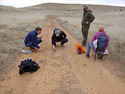
Bobcat project staff (left to right) Liam Jasperse-Sjolander, John Nettles, Rudolplh Mena, Jessica Copeland using stick in process of determining if scat came from bobcat
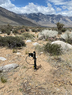
Bobcat project camera station, Inyo County
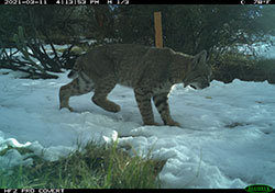
Bobcat in snow, San Diego County
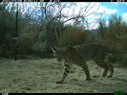
Bobcat in sandy terrain, San Diego County
In the field of wildlife management, one of the most common and sometimes most difficult tasks is to obtain information about a particular species of animal in order to properly manage that species. The California Department of Fish and Wildlife (CDFW) was recently tasked by the State Legislature to conduct a demographic study of a particular species of animal that is known to be elusive and generally secretive, bobcats (Lynx rufus).
Officially known as the California Statewide Bobcat Population Monitoring Project, the study is happening because of a bobcat hunting ban that took effect in 2020. Part of the legislation requires the issue be revisited in 2025, but only after CDFW conducts a statewide population assessment, which will then lead to a science-based bobcat management plan.
Performing this study is complicated by a short timeline due to funding and personnel issues. Because the funding and the positions for those hired to conduct the study both end on June 30, 2022, the challenges of accomplishing this study become even greater. The effort began with forming the Bobcat Management Oversight Group (BOMOG), comprised of key individuals from around the state. That team includes the Deputy Director of Wildlife and Fisheries, the Chief of the Wildlife Branch, and key Regional and Program Managers. The BOMOG quickly realized that for the study to be successful, they would need to bring together a team of individuals from around the state. This resulted in the formation of the Technical Advisory Group (TAG), comprised of some of the top scientists and researchers within CDFW.
“The two groups will ensure project staff are employing consistent field protocols and methods, so the project is a success,” said Wildlife and Fisheries Division Deputy Director Stafford Lehr. “Instead of one unit being responsible, the entire department is responsible for this project.”
The TAG was asked to quickly (within two months) develop a study plan to guide the implementation of the study. The group not only met that deadline but also provided a draft capture plan as well as planned and initiated a pilot project to test the plan prior to its full implementation.
“The TAG’s accomplishments in this very short timeline are a testament to their talent and dedication,” said South Coast Regional Wildlife Program Manager and TAG project lead Rick Mayfield. “This project would not have been possible without their hard work.”
With the planning process completed, CDFW hired a team of 20 people specifically for the project. One was Senior Environmental Scientist Rachel Roberts who, as the lead over this group, faces the challenge of implementation and completion of the study by June 30, 2022. At that point, the data collection will end, and the analysis and creation of a statewide bobcat management plan will begin. This plan, due to be completed by January 2025, will cover all aspects of bobcat management, from demographic information to the effects of habitat loss, wildfires and urbanization on the species.
“It’s kind of funny because we know a lot about bobcats and nothing at the same time,” said Roberts. “We see them in a lot of places and we think that they tend to do well on the edges of urban areas. There have been projects across that state that have collared bobcats, so we have some idea of a home range, but we don’t know specifically all of the different habitats they’re residing in. We have anecdotes of them in orchards, or at high elevations, but that’s one study in one area. This project is trying to get truly to where bobcats are and where they aren’t.”
A few things we do know about bobcats in California: they’re about one fourth the size of a mountain lion, weighing between 12 and 25 pounds depending on environmental conditions. They prey on rabbits, rodents, birds, insects, reptiles and occasionally chickens. Their current population is estimated between 70,000-100,000 statewide. Pelage (fur) markings on their body, legs and face make it possible to distinguish one from another.
To get the most accurate information on California’s bobcat population, Roberts and her team will collect scat samples for fecal DNA analysis. This analysis allows for the individual identification necessary for determining population size via a capture/recapture model. Complementing the scat analysis in assessing the bobcat population, the teams will gather data and photographs in 48 different study areas. Each study area will be 40 square kilometers (just over 15 square miles) and have 80 cameras mounted to record still images of anything that moves in that area, day and night. The motion-activated cameras will shoot images in each study area for six weeks, before being relocated to the next study area.
“We're taking a three-shot, rapid-fire burst with two cameras facing each other at each camera station,” said Roberts. “We're hoping to be able to get photos of the pelage patterns on each bobcat, especially on the insides of their legs – that’s how you can really identify individuals. We're hoping to see these cats more than once so that we may be able to run the capture/recapture model to estimate bobcat density with the camera data as a complement to the scat data.”
“To get their densities and to be able to keep track of individual bobcats, so we know we’re not double-counting them, the DNA in scat is definitely the gold standard,” said Brett Furnas, a biostatistician with the CDFW Wildlife Investigations Lab. “If it’s not a bobcat sample we’re collecting it might be a coyote instead. We confirm that with genetic analysis to make sure what we’re counting is indeed from a bobcat, so we can determine individuals to count them.” Furnas is no stranger to this kind of work. “I’ve worked a lot on deer, so this method of going around and picking up bobcat scat is what we first applied to deer,’ he said. “I’ve also been working with Justin Dellinger (lead of CDFW’s mountain lion monitoring project), so this is the third project in which we’re using genetic information.”
There’s one key difference between the gathering of scat DNA and taking of photographs. Project team members will control how much scat they gather and submit for DNA analysis. Team members won’t have control of the amount of photos that are taken by the nearly 500 hundred motion-activated cameras scattered around the state. The number of photographs to sort through and categorize would be overwhelming, if not for a new company, Wildlife Insights, which stores the images and identifies the animals photographed in the study area.
“All of those photos are uploaded to the cloud and when you open the interface, it has already tagged the animals,” said Roberts. “If it sees turkeys, it has already tagged it. We’re just going in and making sure it’s correct. And, you can just pull out the species that you are interested in. Before, this was all super clunky. We did a pilot study and there were hundreds of thousands of photos, just from two cameras set up for eight weeks.”
Roberts said she’ll visit most of the study areas over the course of the study, but she’d be perfectly happy making it to all 48. The challenge of measuring California’s bobcat population is exactly what she wants to be doing.
Deputy Director Stafford Lehr sees the importance of this work for years to come. “We are striving for a more cohesive approach to applied management throughout the department and we hope this is an improved method of program delivery,” he said. “The importance of having a robust management plan that withstands scientific review and public scrutiny will pay dividends in future programs for the department.”
CDFW Photos