Science Spotlight

Subscribe

Receive Science Institute news by email.

    All Science Spotlight Articles

    rss

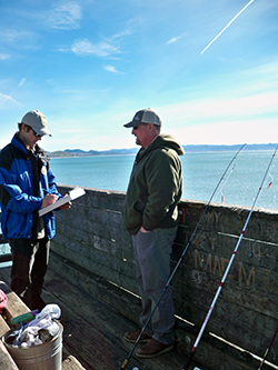
    Two men on a pier, one with a clipboard and the other with a fishing pole
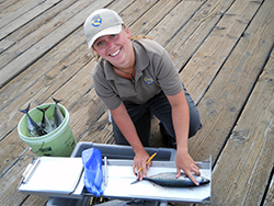
    A young woman measures a fish on a pier.
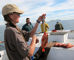
    A young woman weighs a fish on a charter boat
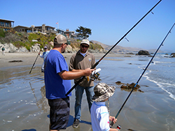
    Two men and a child fishing on a sandy beach
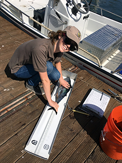
    A young woman wearing a California Fish and Wildlife cap measures a fish on a dock

    If you’re an avid marine sport angler, you have most likely seen the smiling faces and brown polo shirts of California Recreational Fisheries Survey (CRFS) samplers. Since its inception in 2004, CRFS has grown into one of the state’s largest and most important survey efforts. Survey samplers are tasked with collecting data about both recreational fishing catch and effort.

    Annually, CRFS samplers make direct contact with 68,000 fishing parties at over 400 sampling sites between the California-Oregon state line to the California-Mexico border. A separate but related telephone survey effort contacts an additional 26,000 anglers. A program of this large scale is necessary because recreational fishing effort and success rates are highly dynamic – a large sample size is needed to adequately estimate catch and effort. Recreational fishing effort is also very challenging to predict, as it can be affected by many factors (weather, gas prices, time of year, fishing seasons, etc.). But the recreational sector accounts for a significant portion of overall marine harvest, so it’s essential to collect that data to produce reliable estimates of harvest.

    CRFS is part of a larger effort to estimate recreational catch and effort on the west coast and is integral to the national effort conducted by the National Marine Fisheries Service’s Marine Recreational Information Program. This partnership allows CRFS methods to be periodically peer reviewed by expert consultants throughout the country. This review provides certification that the methods meet or exceed national standards and fisheries management needs, and can recommend the use of new methods to address changing needs or to capture emerging fisheries.

    There are three parts to the survey. The first is the field sampling component. This consists of in-person interviews conducted for four different fishing modes – beaches and banks, man-made structures, private/rental boats, and commercial passenger fishing vessels. Field survey questions are specific to catch and effort data during daylight hours at publicly accessible sites. The second part of the survey is the telephone survey. Anglers are randomly selected monthly through the state’s online Automated License Data System (ALDS) and asked about effort data (the number of fishing trips taken) at beach and bank sites. The telephone survey also collects data from private boats returning to sites not sampled during the field survey, and private boats returning at night. The third part of the survey is collection of data from commercial passenger fishing vessel logs. Captains submit this information for every trip, and the data is used together with field sampling data to estimate overall fishing effort.

    All of this information is used in many ways. In addition to CDFW, the Fish and Game Commission and the Pacific Fishery Management Council use the data to:

    • Track in-season catches against annual harvest limits, especially for certain over-fished groundfish species, such as Yelloweye and Cowcod rockfish.
    • Produce in-season salmon estimates in coordination with the CDFW Ocean Salmon Project.
    • Aid the development of regulations, including fishing season, bag limits, minimum size limits and depth limits.
    • Assess stocking needs for individual fish species.

    How can you help? There are two ways! If you encounter a CRFS sampler in the field, please cooperate and answer the interview questions truthfully. Take the time to allow the sampler to examine and measure any catch. Recreational anglers, particularly those who fish frequently, are more likely to encounter CRFS samplers. Every fishing trip is unique — different target species, success rates, different locations, different gear, etc. — so we ask anglers, “Even if you have completed this survey before, please cooperate each time you are asked!”

    Secondly, if you receive a phone call, please say “yes” to the CRFS telephone surveyor. Data collected through this telephone survey is used to estimate fishing effort that cannot be estimated any other way.

    Personal contact information is always kept confidential, and the information that is collected becomes part of a public database. To learn more about the CRFS, access the database or download related flyers and brochures, please visit www.wildlife.ca.gov/Conservation/Marine/CRFS.

    Categories:   General

    sunrise over a California salt marsh
    two young women in a marsh, one holds a tiny mouse

    Deep in the pickleweed in the San Francisco, San Pablo and Suisun Bays, the tiny salt marsh harvest mouse (Reithrodontomys raviventris) tries to avoid predators and compete with other species for prime habitat. Food and cover are abundant, but its overall habitat is shrinking as humans encroach upon its home range. In south San Francisco Bay alone, 95 percent of the historic salt marsh has been lost to industrial parks and subdivisions. Annual flooding in the winter can be perilous, too -- when vegetation is topped by rising tides, the mice must scramble to find taller vegetation or into upland habitat (grasses around the wetlands that don’t get flooded by the tides).

    As part of the effort to monitor and conserve this state- and federally-listed endangered species, biologists conduct annual surveys of the salt marsh harvest mouse. The effort involves setting up traps stuffed with cotton batting and baited with birdseed and walnuts, taking measurements and collecting other data on the subjects that are captured. In some studies, the mice are fitted with GPS collars for tracking, or ear tags to help identify them upon recapture. In other studies, the biologists simply clip away fur on the mouse’s flank or neck – another method that helps them determine whether a mouse in a trap has crossed paths with them before.

    Once a mouse’s measurements have been recorded, they are set loose to scamper back into the pickleweed. The data that’s been collected will later be entered into a larger database that will be accessible to researchers from multiple state agencies (CDFW, the Department of Water Resources), federal agencies (US Fish and Wildlife Service, the US Geological Survey), educational research institutions (UC Davis, CSU San Marcos, San Francisco State) and private industry.

    By comparing population fluctuations and other data throughout the range, scientists hope to identify threats and increase their understanding of this rare rodent’s biology and behavior – ultimately helping to better inform future decisions on habitat management, restoration and enhancement efforts.

    Categories:   Wildlife Research

    A buck with a collar walks through brush on a hillside
    A young woman attaches a trail camera to a dead tree trunk.

    Deer population estimates are an important element of the California Department of Fish and Wildlife’s (CDFW) management decisions regarding the species – including setting quotas for deer-hunting seasons, acquiring land and identifying habitat improvement projects. Historically, CDFW has relied upon helicopter surveys to obtain these population estimates, but such surveys can be problematic. While they are effective in open and largely flat areas, they are less so in tree-laden areas where deer are hidden from sight. They can also be extremely expensive.

    Now, thanks to emerging DNA technology, scientists are exploring a less invasive, cost-effective alternative: Analysis of what the deer leave behind.

    The use of DNA is not new, of course – CDFW has used hair or tissue samples to extract DNA and identify individual animals for years. But scientists are finding that the painstaking collection and analysis of deer droppings is particularly useful because it allows them to gather the necessary information without physically touching (or stressing) the animals. And that, one might say, is the “bottom line.”

    Fecal DNA analysis is being used by wildlife biologists in the North Central Region as part of a six-year region-wide study of mule deer (Odocoileus hemionus) that will provide population estimates in areas where data has previously been lacking. CDFW scientists, in cooperation with UC Davis, will use the deer pellets to take a genetic “fingerprint” designed to help estimate deer populations.

    Starting in 2016, a crew began setting transects for pellet collection in the standardized sampling locations (known to hunters as deer zones X6a/b, X7a/b and X8) which are located in Lassen, Plumas, Sierra, Nevada, Placer and Alpine counties. After starting points were randomly selected, habitat information and pictures were collected along with fresh pellets. After the pellets were removed from the area in an initial sweep, scientists revisited the transect once a week for three more weeks to collect new samples. Between July and September of 2016, biologists visited 43 different transects in the summer range and collected and analyzed 458 fresh pellet samples. Staff also captured 20 does and seven bucks and fit them with satellite collars that produced data that helped identify summer home ranges.

    CDFW will also use DNA to identify individual deer to help gather buck/doe/fawn ratios. Biologists will then combine the DNA data with home range data from collared deer to calculate the estimated number of deer in the population. This year staff have already completed another 36 plots and collared 18 more deer. Another series of pellet collections is scheduled next year, with a goal of continuing until all 17 counties in the region have been sampled.

    Although several DNA projects are occurring across the state, this project is the largest landscape-level study for deer in California. The study is funded through CDFW’s Big Game Account, a dedicated account that provides research and management funds for game species. The University of California will conduct the laboratory work and statistical analysis.

    Categories:   Wildlife Research

    fingerling trout in a man's hands
    Alpine lake under blue sky and mixed clouds
    two boys in small boat hold two fish, each
    A small building, trailer, and five trucks on an isolated hill

    For generations, anglers in California’s eastern Sierra Nevada mountains fished for one of the most cherished fish in the west, the Lahontan cutthroat trout (LCT). These native beauties are prized for their size, with some growing as large as 40 pounds in the Tahoe Basin.

    Sightings of these brown and red native fish have been documented as far back as 1853. But as the population of the state grew, especially during the Gold Rush, the fish were nearly wiped out by mining, development, dams, water diversion and other human factors.

    Today, LCT are listed under both the State and Federal Endangered Species Acts, and CDFW has increased its commitment to angling enthusiasts by providing more opportunity to catch this historic fish. This effort includes greatly expanding the number of waters and fish planted in recent years.

    Every spring, staff from the American River Hatchery in Gold River make the 100-mile journey from the hatchery to the tiny spawning buildings on the shore of Heenan Lake. This pristine body of water is surrounded by granite peaks in remote Alpine County. It is usually not accessible in the winter, cut off by the snowpack, and is only open to catch and release fishing for six weeks a year. It is also the state’s only source of LCT broodstock (groups of mature fish used as the source for eggs and reproduction). Ultimately, the 800,000 eggs spawned at Heenan Lake each year support recreational angling opportunities at multiple locations in the eastern Sierras.

    The staff will make the journey up and down the mountain several times over several weeks to spawn the eggs on site. The process involves carefully bathing the eggs in iodine and suspending them in cheesecloth in aluminum jars about two feet tall, before making the journey back to Sacramento or to other state hatcheries. Some of the eggs head to destinations as far away as Filmore Hatchery in Ventura County.

    Once at the hatcheries, the eggs are placed in “hatching jars,” where chilled, UV-filtered river water circulates over them continuously. After two to three weeks, the eyes of the baby fish are visible inside the eggs. These “eyed” eggs will be addled—a process in which the eggs are siphoned through a tube in order to shake them up. This causes the infertile, diseased or dead eggs to turn white, allowing hatchery technicians to easily identify, pick out and discard them. After the fry hatch, they are moved to deep tanks in the hatchery building, where they will spend approximately five months growing before being moved outdoors to large round tanks.

    The fish will be planted as fingerlings or sub-catchables (fish that weigh 1/16th-1/6th of a pound) into various high-mountain waterways on the east side of the Sierras. At the time of release, they are still too small to be caught, but they will quickly grow to be trophy-sized fish for the state’s anglers who want to make the journey into the high altitudes.

    Categories:   General

    a tiny, gray rodent in a gloved hand
    a tiny, brown rodent in a gloved hand
    a tiny brown rodent in a gloved hand

    A tiny, endangered mammal is the subject of an extraordinary conservation effort near the communities of Shoshone and Tecopa in Inyo County.

    The Amargosa vole is unique to the Mojave Desert, and today, scientists estimate there are only about 500 remaining in the wild. Though the Amargosa vole is rarely seen by humans, biologists recognize that it is a key link in the native food chain. Predators, including raptors and water birds, share the desert marshes where they live, and the extinction of the Amargosa vole would have a ripple effect on these and many other species as well.

    For a year, a scientific team consisting of CDFW, UC Davis and US Geological Survey biologists have conducted intensive research into the life cycle of this little vole. The team visited every marsh that potentially could be inhabited by voles – they mapped the marshes, assessed habitat quality, and determined whether or not voles were present. In a subset of larger marshes the team conducted more detailed assessments of water inflow-outflow, soil moisture and vegetation, and captured voles to estimate local population numbers, assess the health of the voles and take samples for disease and genetics studies. In addition to the hands-on study in the desert, they also studied satellite data to track the amount of vegetation and water in the area over a period of time. A grim picture emerged of a habitat range in decline, due in large part to climate change and human modification.

    Some of the findings included:

    • Total available habitat for the voles decreased 37 percent between 2012 and 2015.
    • Over decades, global climate change has caused a gradual decrease in water in this region. California’s recent drought has exacerbated the problem.
    • Of the more than 80 marshes that were documented at the beginning of the study, about 60 have degraded and/or dried up. Those that remain are almost all too small to sustain vole populations. Just as pandas eat only bamboo, the Amargosa vole survives solely on bulrush, a plant that grows in desert marshes.
    • Another important finding was that 80 percent of the individual voles found and tracked during the study were adults. This indicates low birth rates and survival rates for juveniles – more barriers to the species’ recovery.

    Scientists believe that the network of springs and marshes in the vole’s natural range has been so extensively modified by humans that the vole’s future existence will depend almost entirely on whether humans continue to supply water where and when needed. They found evidence to support this, as an intensive restoration effort at one of the largest marshes showed signs of successfully supporting and sustaining voles.

    The report authors identified several specific measures that could be taken to increase vole habitat and improve their chances of survival – including reconfiguring water inflow and outflow, changing elevations and planting vegetation that would enhance existing marshes and/or better connect adjacent marshes.

    This study is part of a larger long-term effort to secure a future for the Amargosa vole and the unique marsh ecosystems it depends upon in the Mojave Desert. In late 2014 vole numbers became so low that scientists initiated a captive breeding program at the UC Davis School of Veterinary Medicine to reduce the risk of extinction. Today more than 100 voles are in the captive colony at UC Davis – providing a potential source of animals for release into restored habitats, and an important insurance population to prevent extinction.

    Photos by Don Preisler/UC Davis School of Veterinary Medicine

    Categories:   Wildlife Research