Science Spotlight

rss
  • February 23, 2018

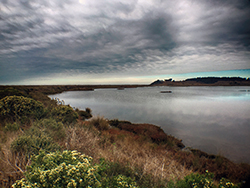
Grass and shrub-covered dunes next to estuary waters, under a cloudy sky
Restoration project area. CDFW photo by Andrew Hughan.
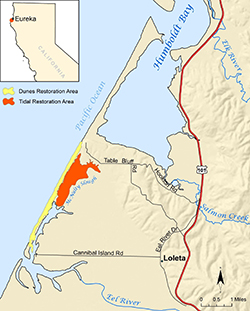
Map with orange and yellow areas to be restored, between Humboldt Bay and the Eel River
Yellow and orange indicate restoration areas at the Ocean Ranch Unit of CDFW's Eel River Wildlife Area.

How does one best go about making an already bountiful and bucolic part of the Golden State even better? Sometimes, perhaps paradoxically, it pays to look to the past in order to be forward thinking in the present.

CDFW, Ducks Unlimited, and many partners have undertaken the Ocean Ranch Unit of the Eel River Wildlife Area Integrative Ecosystem Restoration Project Planning Process to enhance the estuarine and coastal dune ecosystem of the Ocean Ranch Unit in Humboldt County

The approximately 2,600-acre Eel River Wildlife Area was acquired to protect and enhance coastal wetland habitat, and was designated as a wildlife area by the California Fish and Game Commission in 1968. The initial decision to undertake an estuary restoration-planning project began more than a decade ago. After several years of monitoring to gather necessary data, Ducks Unlimited completed a feasibility study, funded by CDFW’s Fisheries Restoration Grant Program and the California State Coastal Conservancy, in December 2015.

The primary goal is to restore and expand natural estuarine and dune ecosystem functions, including the recovery and enhancement of native species (including fish, invertebrates, wildlife and plants) and their habitats. These changes should also help mitigate current and future impacts of climate change. Sea level rise will likely result in saltwater inundation further upstream, which is expected to modify habitats (for example, the loss of tidal marsh migration inland) and the size and shape of the estuary.

The project has been a revelation for Michelle Gilroy, a CDFW district fisheries biologist who works primarily in Humboldt and Del Norte counties.

“For the first time in my 30-year fisheries career, which began in the Eel River watershed, I am achieving a long-time goal of mine: To envision, develop and work through to completion, or near completion, a large restoration project,” said Gilroy. “This exciting project and the extraordinary team I am so very fortunate to work with is making that dream a reality – and in the Eel River estuary, one of California’s largest estuaries. It is definitely one of the highlights of my career.”

Improving the connectivity of tidal and freshwater habitats, and controlling or eradicating invasive plants, are key goals of the restoration project.

A feasibility study guiding the project analyzed the potential for expanding tidal functions within 475 of the 933 acres of the unit to aide in the recovery and enhancement of estuarine habitat and native species. Restoration of these essential habitats is vital to the recovery of anadromous salmonid populations in the Eel River, as estuaries provide critical nursery and rearing conditions for juveniles prior to ocean entry.

The unit is located within the Eel River estuary, a mile and a half north of the mouth of the Eel River and approximately four miles northwest of Loleta. The unit is comprised of a diverse set of habitats, including coastal dunes, riparian woodlands, tidal mudflats, tidal slough channels, salt marshes and managed freshwater marshes.

Prior to second-wave human settlements, this portion of the estuary, then inhabited by Native Americans, consisted primarily of salt-marsh habitat dotted with areas of spruce and hardwood forest, and native grasslands. An abundant fishery, which included the prized salmon, along with native plants, provided sustenance for the Wiyot people who lived around Humboldt Bay and the estuary. As Euro-Americans settled this region, however, they largely drove the Wiyot people off their traditional lands and began to repurpose portions of the environment.

By the end of the 1800s, most of the salt marsh and forestlands were drained and converted to farm and grazing land. This conversion of tidal marshes to pastures was done with purpose – but such perceived progress carried an ecological cost.

The construction of levees and tide gates to drain salt marsh increased sedimentation, flooding, and the amount and diversity of habitat and food supply for fish and wildlife declined throughout the estuary. This degraded the prior functioning, highly productive estuary ecosystem. In addition, invasive species now threaten the diversity or abundance of native species through competition for resources, predation, parasitism, interbreeding with native populations, transmitting diseases, or causing physical or chemical changes to the invaded habitat.

Despite these declines, the Eel River delta, which includes the Eel River Wildlife Area, today continues to provide vital habitat for many aquatic and terrestrial organisms, including state and federally threatened and endangered fish, wildlife and plant species, and many state species of special concern. More than 40 species of mammals and 200 species of birds use the delta area and researchers have documented at least 45 fish species in the Eel River estuary alone.

The area provides essential spawning, nursery and feeding grounds to several commercially and recreationally important species, including Dungeness crab. Estuaries are among the most productive and diverse ecosystems in the world and are one of the preferred habitats for young Dungeness crabs.

Dungeness crabs use estuaries as critical nursery habitat in their juvenile stages, as not only a refuge from predation – particularly in estuaries with structural habitat such as eelgrass – but also because of the abundance and diversity of prey provided by estuaries. Dungeness crabs are opportunistic feeders – clams, fish, isopods and amphipods are their preferred food sources, as well as other Dungeness crabs. Their predators include those larger crabs, octopuses, and fish, including salmon, lingcod and various rockfishes.

Wildlife, of course, is not the only form of life to reap the benefits of this region, as humans enjoy a range of outdoor activities, including fishing, bird-watching, boating, hiking and hunting.

The project is expected to begin in the summer of 2019.

CDFW photos and map

Top photo: CDFW Senior Environmental Scientist Kirsten Ramey and Eric Ojerholm of the Pacific States Marine Fisheries Commission.


Partners, Funding and Staff

Ducks Unlimited, in partnership with CDFW staff, has recently secured project planning funds from the California Wildlife Conservation Board, and initial project implementation funds from the NOAA Restoration Center. To complete the restoration design and environmental compliance process, this second phase of restoration planning will consist of a continued CDFW and Ducks Unlimited partnership, with additional assistance from several local consultants and a Technical Advisory Committee (TAC). The TAC includes representatives from the U.S. Army Corps of Engineers, the Bureau of Land Management, U.S. Fish and Wildlife Service, National Marine Fisheries Service, California Coastal Commission, California State Coastal Conservancy, North Coast Regional Water Quality Control Board, California Sea Grant, California Trout, Humboldt County Resource Conservation District, Humboldt State University, Redwood Region Audubon Society, private landowners, and the Wiyot Tribe. Additional project partners include AmeriCorps, Tom Origer and Associates, Pacific Coast Fish, Wildlife and Wetlands Restoration Association, GHD Inc., H.T. Harvey and Associates, Moffatt and Nichol, Northern Hydrology Engineering, Pacific Coast Joint Venture, and the Pacific States Marine Fisheries Commission.

CDFW staff who have served on the project management team include Michelle Gilroy, Allan Renger, Scott Monday, Kirsten Ramey, James Ray, Mark Smelser, Gordon Leppig, Michael van Hattem, Jennifer Olson, Linda Miller, Clare Golec, Charles Bartolotta, Robert Sullivan, Tony LaBanca, Mark Wheetley, Scott Downie, Adam Frimodig, Jeff Dayton, Mike Wallace, Vicki Frey, John Mello, and Karen Kovacs.


Categories: General
  • February 16, 2018

A black brant, similar to a dark-colored goose, feeds on eelgrass in a sandy bay shoreline.
Banded black brant feeding on eelgrass

A man with a gray beard and glasses, wearing a baseball cap and dark gray jacket, stands next to a spotting scope on a tripod, near Morro Bay, with Morro Rock in the background.
Volunteer John Roser in the field at Morro Bay

Hundreds of dark-colored birds fly together in a bright blue sky
Flock of black brant in flight above Morro Bay

A goose-like seabird with a black beak, dark hood, neck and coat, and white underside floats on bay water
Black brant in Morro Bay

John Roser began hearing the stories shortly after he moved to Los Osos, San Luis Obispo County, on the shores of Morro Bay in the mid-1990s.

Longtime birders, waterfowl hunters, biologists and other coastal residents were all saying the same thing: It seemed fewer black brant were showing up on the bay each winter.

The coastal sea goose is a cultural icon of the area, the signature species of the Morro Bay Winter Bird Festival and a temporary visitor welcomed by locals as the geese arrive each fall from their summer breeding grounds in the Arctic. When the geese are present in big numbers, you can hear their cacophony almost anywhere on the bay from November through April or until the warm environs of Baja California lure the birds farther south on their migration.

Roser, who holds a degree in biology from Cal Poly San Luis Obispo and spent 25 years as an environmental educator, set out to see if the old-timers’ stories were true. For the past 21 years, he has provided CDFW and brant biologists throughout the Pacific Flyway with their most credible and reliable source of data on wintering brant in Morro Bay.<

“I’m retired, and I wanted to take on a volunteer project that would make a difference in this community,” Roser said of his motivation. “I wanted to create a Morro Bay specific data set significant enough that it would be valuable in brant studies and research across the Pacific Flyway.”

Roser’s initial efforts in 1997 focused on reading and reporting bands on individual birds with the help of a high-powered telescope. He has recorded more than 4,000 bands, including one affixed by a Russian ornithologist to a bird in Siberia some 5,000 miles away from Morro Bay where Roser spotted it. In addition to counting individual birds, Roser developed a formula – in consultation with brant biologists – to calculate the number of “brant use days” in Morro Bay each winter.

Roser’s retirement project has led him on a brant-like odyssey.

He banded brant one summer in Alaska, worked in Humboldt Bay with leading brant researcher Jeff Black and his Humboldt State University graduate students, and traveled to Baja California to help biologists read bands on birds at the extreme end of their southern range. Much of Roser’s winter observations take place at CDFW’s Morro Bay Wildlife Area.

“John is our go-to guy on the ground in Morro Bay for sure,” said Melanie Weaver, the head of CDFW’s Waterfowl Program. “We only have two employees in our program, myself included, so we depend on regional staff and volunteers like John to help compile survey data. John is part of the local community, he cares, and he is close to the resource.”

The data Roser supplies are incorporated into CDFW’s Mid-winter Waterfowl Survey, which is used to set hunting regulations for the following waterfowl season.

What attracts brant to Morro Bay is the same thing that prompts the birds to stop at other coastal bays along their southward migration: eelgrass. The underwater seagrass grows in shallow marine environments and is the birds’ primary food source.

Roser’s initial research in 1997 confirmed the reports he was hearing: The wintering brant population in Morro Bay had declined significantly and corresponded with a crash in eelgrass acreage in the bay.

While CDFW surveys from the 1930s through 1960s documented Morro Bay’s wintering brant population as high as 11,800 birds, Roser’s first survey in 1997 recorded a population high of fewer than 700 birds.

The eelgrass crash in the mid-1990s was temporary and well-understood, caused by an influx of sediment from a fire-ravaged landscape, a deluge of freshwater from a rainy year and warming El Nino ocean conditions. As environmental conditions normalized in subsequent years, the eelgrass rebounded, and the brant returned. Roser counted a population high of 4,600 birds in Morro Bay in 2001.

The story since then, as told in Roser’s annual reports to CDFW, is of another dramatic crash in eelgrass acreage in Morro Bay and a corresponding drop in the numbers of brant wintering there. Unlike the eelgrass crash of the mid-1990s, the latest decline has been more persistent and perplexing.

Biologists measure Morro Bay’s eelgrass acreage each year. Eelgrass spanned 344 acres as recently as 2007 but had dwindled to just 14 acres by 2017. Not surprisingly, Roser’s 2016-17 brant survey recorded a population high of just 319 birds and a low of 43. Roser’s brant-use-day metric has fallen by 90 percent since the nearly 500,000 brant use days he recorded in 2001. In the past five years, brant use days have measured around 50,000 a year. Money from the purchase of the California duck stamp-validation, required to hunt waterfowl in California, is funding research into the eelgrass decline along with restoration efforts.

In addition to fewer numbers of brant frequenting Morro Bay, Roser has noticed behavioral changes in the birds that still show up. Increasingly, the brant are foraging on secondary food sources that include salt marsh vegetation and green algae species such as sea lettuce with eelgrass in short supply.

Roser takes some solace that the overall Pacific Flyway brant population is holding steady if not increasing, estimated between 130,000 to 165,000 birds. Roser says waterfowl biologists are seeing flyway-wide changes in brant behavior that they suspect may be linked to climate change.

Fewer brant are migrating to Mexico for the winter. More are remaining in Alaska and their northern range throughout the year as warming Arctic conditions require fewer calorie demands and less ice exposes more eelgrass. Ten years ago, less than 10 percent of the population wintered in Alaska. By 2017, almost 40 percent of the Pacific Flyway population spent the winter there.

“This bird is tied to Morro Bay, our culture and our identity,” Roser said. “A robust wintering brant population needs abundant eelgrass beds. Eelgrass needs a healthy bay and watershed. Our actions as stewards of Morro Bay really do reverberate across the globe.”

CDFW photos: courtesy of John Roser
Top photo: Pair of black brant on Morro Bay

Categories: General
  • January 30, 2018

The latest issue of California Fish and Game, 103-3, makes a significant contribution to the body of research related to longfin smelt in California. A paper titled, “link opens in new windowHistoric and contemporary distribution of Longfin Smelt (Spirinchus thaleichthys) along the California coast (PDF)” analyzes and presents observation data for this species from a variety of published and unpublished sources dating from 1889 to 2016. This anadromous fish, which is listed as threatened under the California Endangered Species Act, has been documented in a diverse range of habitats, including coastal lagoons, bays, estuaries, sloughs, tidal freshwater streams and nearshore habitats. In addition to providing a comprehensive look at the existing information available for longfin smelt along the California coast, this paper identifies additional information needed to improve management and enhance recovery of the species within the state.

In “link opens in new windowDistribution and derivation of dabbling duck harvests in the Pacific Flyway (PDF),” the authors look at abundance, banding and harvest data from throughout the Pacific Flyway and other important source areas in the Central Flyway to estimate the distribution and derivation of Pacific Flyway dabbling duck harvests during 1966−2013. The Pacific Flyway has long been considered an important wintering area for dabbling ducks. Better knowledge of the origins of these birds could assist in both harvest and habitat management.

The authors of “link opens in new windowDistribution of Amargosa River pupfish (Cyprinodon nevadensis amargosae) in Death Valley National Park, CA (PDF)” endured harsh environmental conditions to document the occurrence of Amargosa River pupfish along the lower Amargosa River drainage where the species has not been previously documented. The downstream-most location of Amargosa pupfish captured in this study extends the previously recorded geographic range approximately 49 river km. The findings not only determine the distribution of Amargosa River pupfish within Death Valley National Park, but will help identify suitable locations at which to establish long-term monitoring sites.

California Fish and Game has published high-quality, peer-reviewed science for the past 103 years, making important contributions to the understanding and conservation of California’s wildlife.

Cover photo courtesy of Gerald and Buff Corsi © California Academy of Sciences.

Categories: California Fish and Game Journal
  • January 22, 2018

silvery tilapia skin on the bottom of a bear's paw
The tilapia skin is visible on the bottom of the bear's paw.

Two veterinarians look at an ultrasound image, behind an anesthetized bear lying on her back.
Veterinarians perform an ultrasound to check on the progress of the second bear's pregnancy.

An anesthetized adult bear lies on her side, on a veterinary table, with eight acupuncture needles stuck in her legs, shoulder, paws and snout
Acupuncture needles assist with pain management.

A sad-looking bear looks up from an artificial enclosure
After placing the second bear, the team moved the first bear to another location where another man-made den awaited.

Two women and a man build a bear den of fallen logs and forest materials in the wilderness
CDFW staff work together to build a makeshift den for a soft release in Los Padres National Forest. A soft release involves putting the bear in a den to simulate hibernation, and leaving it to wake up on its own.

Two talented veterinarians, an environmental scientist and several dedicated staff members at the CDFW Wildlife Investigations Lab recently put their heads and their resources together to help heal a pair of adult bears that were badly burned in the Thomas Fire. The bears, which were treated at the same time as a young mountain lion with similar, less severe burn injuries, were released back to the wild last Thursday, after several weeks of intensive – and unusual – care.

CDFW Senior Wildlife Veterinarian Dr. Deana Clifford was acting manager of the Wildlife Investigations Lab in Rancho Cordova when the first bear – an adult female weighing about 200 pounds – was captured inside of a backyard aviary in the Ojai area on December 9. With CDFW Environmental Scientist Christine Thompson coordinating, CDFW Wildlife Officer Jacob Coombs darted the bear and local veterinarian Dr. Duane Tom evaluated its injured paws and overall condition. Thompson then conferred with Clifford, who determined the bear might have a chance at recovery if treated quickly. The bear was put into a trailer for the seven-hour transport to Rancho Cordova, where Clifford was waiting.

By the time the bear arrived, Clifford had already reached out to Dr. Jamie Peyton, Chief of Integrative Medicine at the UC Davis Veterinary Teaching Hospital, for help. Weeks earlier, Peyton, who works mostly on domestic animals, had mentioned to Clifford in passing that she had a particular interest in animal burns, and would be interested in helping wildlife if the chance ever arose.

Peyton created a homemade burn salve for the bears’ paws, and a process for sterilizing tilapia skin. Fish skin, which contains collagen, is often used by doctors in Brazil to bandage human burns. The technique is not yet approved by the Food and Drug Administration for use in the United States, and had not been tried on veterinary patients.

To help keep the tilapia skin in place, Peyton cut pieces to exactly match the size of the bear’s paws and then sutured them over the wounds while the bear was under anesthesia. Additional temporary wrappings, including rice paper and corn husks, were added, with the intention of stretching out the amount of time it would take for the animal to chew down to the fish skin bandage. “We expected the outer wrapping to eventually come off, but we hoped the tilapia would keep steady pressure on the wounds and serve as an artificial skin long enough to speed healing of the wounds underneath,” Peyton said. She also used acupuncture to aid the bear with pain management.

The original plan was for Peyton to come to the lab weekly to check on the bear’s progress. But within just a few weeks, two more burn patients arrived from the Thomas Fire. A second adult female bear, found relatively close to where the first one was found, was brought to the lab by Thompson on December 22. And on December 23, the young mountain lion arrived from Santa Paula. The experimental tilapia treatment was extended to the two newcomers as well.

Of the three animals, the mountain lion’s injuries were the least severe. Because of his young age, he was earmarked for placement in a wildlife rescue facility. The two bears were in much worse condition, with oozing wounds and, in some cases, paw pads that were completely burned off. But because the bears were older and stronger, the veterinarians hoped to return them to the wild if their injuries could be healed.

To complicate matters further, on December 28, during a routine burn treatment, Clifford’s team performed an ultrasound on each bear, and found that the second bear was pregnant. The quest to heal the mother-to-be was now a race against time.

“That was a game changer for us, because we knew it wouldn’t be ideal for her to give birth in confinement,” Clifford said. “We aren’t really set up to have a birth at the lab holding facilities, and we knew there was a high probability that she could reject the cub, due to all the stress she was under. We needed to get her back into the wild as quickly as possible.”

While Clifford and Peyton continued to focus on healing the animals’ injuries, Thompson started scouting out potential release locations. Since both bears needed to be transported back to Southern California, it was decided to try to return them at the same time – albeit not exactly in the same location – in order to make the best use of staff time and resources.

Both bears’ original habitat had been destroyed by fire, so Thompson scouted for two new locations that fit several parameters. The bears needed to be close to their home range, but not within the burn area, and near ample food and water sources. She also wanted to keep them as far away from each other as possible. “A lot of wildlife habitat was destroyed by the fire, and there are already a lot of displaced animals roaming around,” Thompson said. “So there’s a good chance that whatever location we choose is already occupied by other bears, but only they know exactly where that designated territory is. The best we can do is make an educated guess, and place them as deep into wild lands as possible.”

Taking the rapidly changing winter weather reports into careful consideration, the team chose Wednesday, January 17, as the target date to get on the road. That morning, Peyton came to the Wildlife Investigations Lab one last time and both bears were immobilized for a final treatment for their feet. Then the bears were placed into separate transport trailers for the long journey home. Simultaneously, in the Los Padres National Forest, Thompson and Tom spent the day digging dirt and moving logs to create a winter den for each bear.

“At this time of the year, most bears have established dens for the winter, but since these bears won’t have time to create a den, we hope to improve their chances of survival by creating a den for them so they have a home base and shelter right away,” Clifford explained.

The team arrived late Wednesday night, and both staff and bears were hosted overnight by the Ventura County Sheriff’s Department. Early on the morning of January 18, Clifford, Thompson, Coombs, Tom and their team drove the bears deep into the forest for the final leg of their journey. One at a time, each bear was sedated and carefully placed into her den, while the team finished constructing a shelter around the slumbering animal. The bears are about five miles apart, as the crow flies, and each is wearing a satellite collar so CDFW can monitor her movements and survival post-release. Staff also placed trail cameras near each den.

“We’re really hopeful that these novel treatments accelerated the healing for these bears and provided them the best odds of survival,” Clifford said. “It’s especially good to know that we’ve maximized the odds of survival for the cub on the way. We don’t know exactly when it will be born, but hopefully we’ll be able to monitor the movements of the mother via satellite, and that will give us an indication of how things are going.”

For Clifford, the entire experience wasn’t simply about saving the lives of two bears. The bigger picture involves the body of knowledge the experimental treatment provided – both to the Wildlife Investigations Lab team and to the UC Davis Veterinary Teaching Hospital.

“This treatment has the potential to be used successfully on all kind of burn patients, both domestic and wild,” Clifford said. “For us, at the Wildlife Investigations Lab, it’s been an invaluable experience because California’s changing climate means that we’re likely to see more wild animals impacted by catastrophic wildfires. By better understanding what resources are needed to care for injured wildlife and what treatment techniques increase healing speed, we can make the most informed treatment decisions, reduce animals’ time in captivity and provide guidance to other facilities caring for burned animals.”

CDFW photos. For more, please see CDFW’s Flickr photo album: link opens in new windowThomas Fire Bears.

Top photo: The first bear rests in her holding enclosure after her treatment is finished. The outer wrapping on her feet (made of corn husks) will delay her efforts to chew off the tilapia skin bandages underneath.

Categories: General
  • January 19, 2018

An audio recording device in a semi-clear, plastic container on dark brown ground
The automated recorder model the scientists used. (CDFW photo by Brett Furnas)

Two avian researchers recently completed a groundbreaking study on the effects of climate change, based on the calls of California’s songbirds. By recording the sounds made by eight different songbird species, and tracking the dates they are most vocal and how frequently they sing, the scientists were able to develop a method to measure how the birds are adjusting to climate change.

CDFW Wildlife Ecologist Dr. Brett Furnas and William Jessup University’s Professor Michael McGrann analyzed data from two bird surveys, one done by CDFW and another led by William Jessup University, in the Klamath Mountains and Southern Cascades of northern California. Both studies used automated recorders to monitor bird sounds between 2009 and 2011. The results of their analysis, detailed in a research article entitled Using Occupancy Modeling to Monitor Dates of Peak Vocal Activity for Passerines in California, were published this month in a peer-reviewed, international journal of ornithology, The Condor: Ornithological Applications.

Furnas and McGrann’s study was prompted by the scientists’ concern that climate change could throw bird’s reproduction cycles out of sync with the seasons. Their work, which represents the first comprehensive assessment of songbird occupancy over approximately 15,000 square miles in California, earned high praise from Steve Beissinger, an expert on avian phenology at the University of California, Berkeley.

“Furnas and McGrann provide a textbook example of how to detect differences in the timing of nesting among bird species using information on the peak date of singing derived from surveys and automated recorders,” Beissinger said. “Their results support recent findings of a five-to-twelve day shift forward in the timing of peak singing by California birds in the nearby Sierra Nevada and coastal ranges in response to climate change.”

Because birds’ songs are correlated with their breeding behavior and are easily identifiable to species, the scientists found them to be a useful tool to provide new baseline data for the birds of northern California. Working together, they identified the precise dates of peak vocal activity for eight songbird species: Hutton’s vireo, hermit thrush, dark-eyed junco, Nashville warbler, MacGillivray’s warbler, yellow warbler, western tanager and black-headed grosbeak. In addition to gathering baseline data, Furnas and McGrann developed a method to track advances in the timing of vocal activity in the coming decades.

Male songbirds sing for several reasons -- including to advertise their territory or to find a mate with which to breed. When birds are at their most vocal, they are usually near the height of their breeding season, Furnas explained.

Much like the call of the imperiled “canary in the coal mine,” changes in the frequency or timing of these native birdsongs can serve as barometers of the cumulative impact of climate change.

“When the canary starts singing you know that there is a danger, such as a buildup of dangerous gasses in a mine,” Furnas explained. “When the birds in our study start singing earlier in the season, they are warning us that climate change is starting to disrupt complex ecological cycles that developed slowly over millions of years of evolution.”

One of the most interesting findings of the study so far is a hint in the baseline data that migratory birds may be at greater risk than non-migratory birds. “We found the highest singing activity for migrant birds spanned a shorter number of days than the highest singing activity for non-migratory birds,” Furnas said. “This could be because migratory birds have less flexibility to shift the timing of their breeding cycle. If they are prompted by increasing temperatures to migrate earlier in the year, they may arrive at their breeding grounds to find they don’t have enough insects to eat.

“Migratory birds have to compress a lot of activities into a shorter time period with less margin for error,” Furnas explained. “Think of it like scheduling a short holiday somewhere nice, but when you show up, bad weather cancels out a lot of your itinerary.”

This, in turn, negatively affects the very biodiversity that CDFW is responsible for monitoring.

“If all the species adjusted their ecologies similarly, perhaps that would be OK, but unfortunately, we expect that different insects and birds will react in different ways leading to a mismatch of conditions,” Furnas said.

Both CDFW and William Jessup University plan to continue bird surveys over the long term so that California has the information to support effective management of climate change and other conservation challenges.

Top photo: Singing hermit warbler, one of the species addressed in the study. (CDFW photo by Michael McGrann)

Categories: Wildlife Research
CDFW Science Institute logo

Subscribe

Receive Science Institute news by email.