Science Spotlight

rss
  • August 8, 2017

A woman in a marsh holds a turtle
Two men in a marsh, one holds a turtle
Gloved hands hold a pond turtle with long claws
A man throws a trap into a marsh slough
A pond turtle in a marsh pond
Pond turtle's face, close-up
Gloved hands hold a pond turtle as someone neasures its height
Hands hold a six-inch pond turtle with long claws

Does the Western pond turtle (Actinemys marmorata), a freshwater species native to the Pacific Coast, hold secrets to survive climate change and adapt to rising sea levels? CDFW biologists want to know and have partnered with UC Davis and the Department of Water Resources to conduct a long-term study in Solano County’s Suisun Marsh to better understand the aquatic reptiles.

Officially, the Western pond turtle is a Species of Special Concern in California because of declining populations brought about by habitat loss, degradation and competition from that pet store favorite – the non-native, red-eared slider. The pet slider turtles are often released into the environment by their owners after outgrowing or outliving their welcome. They also outgrow and out-compete the medium-sized western pond turtles for food and critical basking spots. Western pond turtle populations are faring even worse in Oregon and Washington.

And yet in the Suisun Marsh, with its brackish water and high salinity, the Western pond turtle appears to be thriving. The Suisun Marsh, ironically, may now be home to one of the strongest populations of Western pond turtles on the West Coast.

“It’s just a really unique population in a place where we didn’t expect to see a freshwater species,” said Mickey Agha, the UC Davis Ph.D. student leading the link opens in new windowuniversity’s turtle research with Dr. Brian Todd, an associate professor in the UC Davis Department of Wildlife, Fish and Conservation Biology.

As if to underscore the point, researchers this summer collected a turtle with a barnacle attached to its shell – a testament to the marine-like environment to which the Suisun Marsh turtles have adapted.

Researchers also have been impressed with the age, health and size of the individual turtles. At 1 ½ to 2 pounds and with an upper shell that stretches up to 8 inches in length, researchers are discovering some of the largest Western pond turtles ever recorded in California.

“Looking at the ones we’ve collected, we’re seeing a lot of healthy turtles in good body condition,” said Environmental Scientist Melissa Riley, who is leading CDFW’s efforts.

The research began in the summer of 2016 with scientists trying to get a basic sense of turtle population numbers. The turtles are trapped in baited, floating hoop nets, their size, weight and age recorded. Before being released, each turtle is marked by filing a unique pattern of small notches along the edges of the upper shell. More than 125 turtles have been recorded in the project’s database.

Turtle trapping is taking place on three sites at the Suisun Marsh in and around the Grizzly Island Wildlife Area. Biologists are particularly interested in turtles at the Hill Slough Wildlife Area along Grizzly Island Road as 500 acres there will soon be restored to tidal marshland. Biologists plan to affix tiny, solar-powered, GPS tracking devices to some of the turtles to study their movements and see how they respond to the increasingly saltwater environment at Hill Slough and other parts of the marsh.

“That’s one of the many questions we have,” Agha said. “If sea level rise occurs, what happens to these turtles?”

Categories: General
  • July 25, 2017

Five deer wade knee-deep in blue lake water
cute face of a mule deer

Three people check and attach a collar to a doe
doe on a hillside wears a research collar
Mule deer buck in a dry meadow
Two people collect deer pellets from a trail
Doe and fawn look out from a dry-grassy ridge

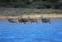
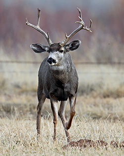
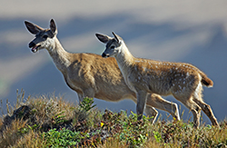
As California deer hunters head to the fields, forests and mountains this summer and fall, their experiences will provide wildlife biologists with key data on the health of the state’s deer herds. Wildlife biologists are already seeing the benefits of a 2015 regulation change requiring all deer tag holders to report how they did – successful or not – along with how many days they actually spent hunting, even if they never made it out at all. A record 84 percent of deer tag holders submitted harvest reports for 2016.

“We’re getting more accurate and precise numbers for harvest than we’ve ever had before, which is critical for calculating the tag quota for the next year and conserving our deer populations for the future,” said Stuart Itoga, a senior environmental scientist with CDFW and the state’s deer program coordinator.

Until recently, accurate deer harvest data had proved elusive. Prior to 2015, only successful California deer hunters had to report their take and only about 30 percent of those actually complied. CDFW supplemented the harvest data with numbers collected from game processing facilities, an inefficient process that still left an incomplete picture.

“It’s Wildlife Management 101,” Itoga said. “You have to know what your population is, what’s coming in and what’s going out. We needed to have better numbers.”

Following the mandatory reporting requirement in 2015, submittal rates for deer tag harvest reports jumped to 50 percent. In 2016, a $21.60 non-reporting penalty took effect, which applies to the purchase of future tags, and boosted reporting to the all-time high.

Mandatory deer tag reporting data is just one of a number of new tools that has CDFW deer biologists excited about their ability to better assess California’s deer herds. 
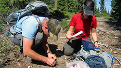
An innovative DNA study of deer feces promises to give biologists new information about the size and characteristics of the state’s deer population.

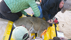
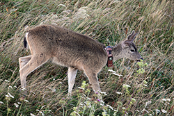
CDFW has also greatly expanded the use of deer tracking collars, thanks to improved technology. Since 2016, CDFW has affixed the relatively lightweight, remotely programmable, GPS tracking devices on 350 deer to learn more about their preferred habitat, in-state and out-of-state migration routes and sources of mortality other than hunting. Advanced camera technology also promises to improve the data collected from CDFW’s aerial and ground-based population surveys. A new computer model is being developed to incorporate all of these new data sources into more sophisticated, accurate and precise deer population estimates.

“It’s really an exciting time to be doing this type of work,” Itoga said. “We’ve always used the best available science, but with technology moving at the pace it’s moving now, we have tools available to us now that we didn’t have even five years ago.”

Management changes can happen more quickly as a result. For the upcoming 2017 deer hunting seasons, for example, deer tag quotas were cut in half in three highly desirable, Eastern Sierra X Zones – X9a, X9b and X12 – as a result of new data and field work that showed that migratory deer in these areas suffered from the long, intense winter.

“Winter survival was poor,” Itoga said. “Our hope is that if we reduce the harvest this year, the populations will have a chance to rebound and increase next year.”

Categories: General
  • July 18, 2017

duck with brown head and body, black back and beak, and red eyes
grayish-brown duck with black and green wing feathers

The California Department of Fish and Wildlife (CDFW) has completed its annual waterfowl breeding population survey.

Mallards, gadwall and cinnamon teal comprised 54 percent of the ducks observed, down 30 percent from last year. The number of mallards decreased from 263,774 to 198,392 (a decrease of 25 percent) and total ducks decreased from 417,791 to 396,529 (a decrease of five percent).

The most notable decrease occurred in the Sacramento Valley area, where mallards were estimated at a record low of 31,000 (73 percent below the long-term average).

Given the abundant precipitation, one might expect the numbers to be higher. In some parts of the state, it did indeed increase available habitat (uplands and ponds). But in many areas, last winter’s heavy rains largely resulted in deep, fast-flowing water, which is not ideal for dabbling ducks. Other reasons for low duck observations could include winter flooding of nesting habitat that normally remains dry, the late-season flooding of the rice fields in the Sacramento Valley and the conversion of rice fields and pastures to tree crops.

CDFW biologists and warden pilots have conducted this annual survey using fixed-wing aircraft since 1948. This year’s survey was conducted from April 3 through May 4 in the Central Valley, and May 9-10 in northeastern California. The population estimates are for the surveyed areas only, which include the majority of the suitable duck nesting habitat in the state. Surveyed areas include wetland and agricultural areas in northeastern California, throughout the Central Valley, the Suisun Marsh and some coastal valleys.

The full Breeding Population Survey Report can be found at www.wildlife.ca.gov/conservation/birds/waterfowl.

The majority of California’s wintering duck population originates from breeding areas surveyed by the U.S. Fish and Wildlife Service (USFWS) in Alaska and Canada. Those survey results should be available in early August. CDFW survey information, along with similar data from other Pacific Flyway states, is used by the USFWS and the Pacific Flyway Council when setting hunting regulations for the Pacific Flyway states, including California.

Categories: General
  • July 6, 2017

Two men on a pier, one with a clipboard and the other with a fishing pole
A young woman measures a fish on a pier.
A young woman weighs a fish on a charter boat
Two men and a child fishing on a sandy beach
A young woman wearing a California Fish and Wildlife cap measures a fish on a dock

If you’re an avid marine sport angler, you have most likely seen the smiling faces and brown polo shirts of California Recreational Fisheries Survey (CRFS) samplers. Since its inception in 2004, CRFS has grown into one of the state’s largest and most important survey efforts. Survey samplers are tasked with collecting data about both recreational fishing catch and effort.

Annually, CRFS samplers make direct contact with 68,000 fishing parties at over 400 sampling sites between the California-Oregon state line to the California-Mexico border. A separate but related telephone survey effort contacts an additional 26,000 anglers. A program of this large scale is necessary because recreational fishing effort and success rates are highly dynamic – a large sample size is needed to adequately estimate catch and effort. Recreational fishing effort is also very challenging to predict, as it can be affected by many factors (weather, gas prices, time of year, fishing seasons, etc.). But the recreational sector accounts for a significant portion of overall marine harvest, so it’s essential to collect that data to produce reliable estimates of harvest.

CRFS is part of a larger effort to estimate recreational catch and effort on the west coast and is integral to the national effort conducted by the National Marine Fisheries Service’s Marine Recreational Information Program. This partnership allows CRFS methods to be periodically peer reviewed by expert consultants throughout the country. This review provides certification that the methods meet or exceed national standards and fisheries management needs, and can recommend the use of new methods to address changing needs or to capture emerging fisheries.

There are three parts to the survey. The first is the field sampling component. This consists of in-person interviews conducted for four different fishing modes – beaches and banks, man-made structures, private/rental boats, and commercial passenger fishing vessels. Field survey questions are specific to catch and effort data during daylight hours at publicly accessible sites. The second part of the survey is the telephone survey. Anglers are randomly selected monthly through the state’s online Automated License Data System (ALDS) and asked about effort data (the number of fishing trips taken) at beach and bank sites. The telephone survey also collects data from private boats returning to sites not sampled during the field survey, and private boats returning at night. The third part of the survey is collection of data from commercial passenger fishing vessel logs. Captains submit this information for every trip, and the data is used together with field sampling data to estimate overall fishing effort.

All of this information is used in many ways. In addition to CDFW, the Fish and Game Commission and the Pacific Fishery Management Council use the data to:

  • Track in-season catches against annual harvest limits, especially for certain over-fished groundfish species, such as Yelloweye and Cowcod rockfish.
  • Produce in-season salmon estimates in coordination with the CDFW Ocean Salmon Project.
  • Aid the development of regulations, including fishing season, bag limits, minimum size limits and depth limits.
  • Assess stocking needs for individual fish species.

How can you help? There are two ways! If you encounter a CRFS sampler in the field, please cooperate and answer the interview questions truthfully. Take the time to allow the sampler to examine and measure any catch. Recreational anglers, particularly those who fish frequently, are more likely to encounter CRFS samplers. Every fishing trip is unique — different target species, success rates, different locations, different gear, etc. — so we ask anglers, “Even if you have completed this survey before, please cooperate each time you are asked!”

Secondly, if you receive a phone call, please say “yes” to the CRFS telephone surveyor. Data collected through this telephone survey is used to estimate fishing effort that cannot be estimated any other way.

Personal contact information is always kept confidential, and the information that is collected becomes part of a public database. To learn more about the CRFS, access the database or download related flyers and brochures, please visit www.wildlife.ca.gov/Conservation/Marine/CRFS.

Categories: General
  • June 23, 2017

sunrise over a California salt marsh
two young women in a marsh, one holds a tiny mouse

Deep in the pickleweed in the San Francisco, San Pablo and Suisun Bays, the tiny salt marsh harvest mouse (Reithrodontomys raviventris) tries to avoid predators and compete with other species for prime habitat. Food and cover are abundant, but its overall habitat is shrinking as humans encroach upon its home range. In south San Francisco Bay alone, 95 percent of the historic salt marsh has been lost to industrial parks and subdivisions. Annual flooding in the winter can be perilous, too -- when vegetation is topped by rising tides, the mice must scramble to find taller vegetation or into upland habitat (grasses around the wetlands that don’t get flooded by the tides).

As part of the effort to monitor and conserve this state- and federally-listed endangered species, biologists conduct annual surveys of the salt marsh harvest mouse. The effort involves setting up traps stuffed with cotton batting and baited with birdseed and walnuts, taking measurements and collecting other data on the subjects that are captured. In some studies, the mice are fitted with GPS collars for tracking, or ear tags to help identify them upon recapture. In other studies, the biologists simply clip away fur on the mouse’s flank or neck – another method that helps them determine whether a mouse in a trap has crossed paths with them before.

Once a mouse’s measurements have been recorded, they are set loose to scamper back into the pickleweed. The data that’s been collected will later be entered into a larger database that will be accessible to researchers from multiple state agencies (CDFW, the Department of Water Resources), federal agencies (US Fish and Wildlife Service, the US Geological Survey), educational research institutions (UC Davis, CSU San Marcos, San Francisco State) and private industry.

By comparing population fluctuations and other data throughout the range, scientists hope to identify threats and increase their understanding of this rare rodent’s biology and behavior – ultimately helping to better inform future decisions on habitat management, restoration and enhancement efforts.

Categories: Wildlife Research
CDFW Science Institute logo

Subscribe

Receive Science Institute news by email.