Science Spotlight

rss
  • June 13, 2017

A buck with a collar walks through brush on a hillside
A young woman attaches a trail camera to a dead tree trunk.

Deer population estimates are an important element of the California Department of Fish and Wildlife’s (CDFW) management decisions regarding the species – including setting quotas for deer-hunting seasons, acquiring land and identifying habitat improvement projects. Historically, CDFW has relied upon helicopter surveys to obtain these population estimates, but such surveys can be problematic. While they are effective in open and largely flat areas, they are less so in tree-laden areas where deer are hidden from sight. They can also be extremely expensive.

Now, thanks to emerging DNA technology, scientists are exploring a less invasive, cost-effective alternative: Analysis of what the deer leave behind.

The use of DNA is not new, of course – CDFW has used hair or tissue samples to extract DNA and identify individual animals for years. But scientists are finding that the painstaking collection and analysis of deer droppings is particularly useful because it allows them to gather the necessary information without physically touching (or stressing) the animals. And that, one might say, is the “bottom line.”

Fecal DNA analysis is being used by wildlife biologists in the North Central Region as part of a six-year region-wide study of mule deer (Odocoileus hemionus) that will provide population estimates in areas where data has previously been lacking. CDFW scientists, in cooperation with UC Davis, will use the deer pellets to take a genetic “fingerprint” designed to help estimate deer populations.

Starting in 2016, a crew began setting transects for pellet collection in the standardized sampling locations (known to hunters as deer zones X6a/b, X7a/b and X8) which are located in Lassen, Plumas, Sierra, Nevada, Placer and Alpine counties. After starting points were randomly selected, habitat information and pictures were collected along with fresh pellets. After the pellets were removed from the area in an initial sweep, scientists revisited the transect once a week for three more weeks to collect new samples. Between July and September of 2016, biologists visited 43 different transects in the summer range and collected and analyzed 458 fresh pellet samples. Staff also captured 20 does and seven bucks and fit them with satellite collars that produced data that helped identify summer home ranges.

CDFW will also use DNA to identify individual deer to help gather buck/doe/fawn ratios. Biologists will then combine the DNA data with home range data from collared deer to calculate the estimated number of deer in the population. This year staff have already completed another 36 plots and collared 18 more deer. Another series of pellet collections is scheduled next year, with a goal of continuing until all 17 counties in the region have been sampled.

Although several DNA projects are occurring across the state, this project is the largest landscape-level study for deer in California. The study is funded through CDFW’s Big Game Account, a dedicated account that provides research and management funds for game species. The University of California will conduct the laboratory work and statistical analysis.

Categories: Wildlife Research
  • June 8, 2017

fingerling trout in a man's hands
Alpine lake under blue sky and mixed clouds
two boys in small boat hold two fish, each
A small building, trailer, and five trucks on an isolated hill

For generations, anglers in California’s eastern Sierra Nevada mountains fished for one of the most cherished fish in the west, the Lahontan cutthroat trout (LCT). These native beauties are prized for their size, with some growing as large as 40 pounds in the Tahoe Basin.

Sightings of these brown and red native fish have been documented as far back as 1853. But as the population of the state grew, especially during the Gold Rush, the fish were nearly wiped out by mining, development, dams, water diversion and other human factors.

Today, LCT are listed under both the State and Federal Endangered Species Acts, and CDFW has increased its commitment to angling enthusiasts by providing more opportunity to catch this historic fish. This effort includes greatly expanding the number of waters and fish planted in recent years.

Every spring, staff from the American River Hatchery in Gold River make the 100-mile journey from the hatchery to the tiny spawning buildings on the shore of Heenan Lake. This pristine body of water is surrounded by granite peaks in remote Alpine County. It is usually not accessible in the winter, cut off by the snowpack, and is only open to catch and release fishing for six weeks a year. It is also the state’s only source of LCT broodstock (groups of mature fish used as the source for eggs and reproduction). Ultimately, the 800,000 eggs spawned at Heenan Lake each year support recreational angling opportunities at multiple locations in the eastern Sierras.

The staff will make the journey up and down the mountain several times over several weeks to spawn the eggs on site. The process involves carefully bathing the eggs in iodine and suspending them in cheesecloth in aluminum jars about two feet tall, before making the journey back to Sacramento or to other state hatcheries. Some of the eggs head to destinations as far away as Filmore Hatchery in Ventura County.

Once at the hatcheries, the eggs are placed in “hatching jars,” where chilled, UV-filtered river water circulates over them continuously. After two to three weeks, the eyes of the baby fish are visible inside the eggs. These “eyed” eggs will be addled—a process in which the eggs are siphoned through a tube in order to shake them up. This causes the infertile, diseased or dead eggs to turn white, allowing hatchery technicians to easily identify, pick out and discard them. After the fry hatch, they are moved to deep tanks in the hatchery building, where they will spend approximately five months growing before being moved outdoors to large round tanks.

The fish will be planted as fingerlings or sub-catchables (fish that weigh 1/16th-1/6th of a pound) into various high-mountain waterways on the east side of the Sierras. At the time of release, they are still too small to be caught, but they will quickly grow to be trophy-sized fish for the state’s anglers who want to make the journey into the high altitudes.

Categories: General
  • May 31, 2017

a tiny, gray rodent in a gloved hand
a tiny, brown rodent in a gloved hand
a tiny brown rodent in a gloved hand

A tiny, endangered mammal is the subject of an extraordinary conservation effort near the communities of Shoshone and Tecopa in Inyo County.

The Amargosa vole is unique to the Mojave Desert, and today, scientists estimate there are only about 500 remaining in the wild. Though the Amargosa vole is rarely seen by humans, biologists recognize that it is a key link in the native food chain. Predators, including raptors and water birds, share the desert marshes where they live, and the extinction of the Amargosa vole would have a ripple effect on these and many other species as well.

For a year, a scientific team consisting of CDFW, UC Davis and US Geological Survey biologists have conducted intensive research into the life cycle of this little vole. The team visited every marsh that potentially could be inhabited by voles – they mapped the marshes, assessed habitat quality, and determined whether or not voles were present. In a subset of larger marshes the team conducted more detailed assessments of water inflow-outflow, soil moisture and vegetation, and captured voles to estimate local population numbers, assess the health of the voles and take samples for disease and genetics studies. In addition to the hands-on study in the desert, they also studied satellite data to track the amount of vegetation and water in the area over a period of time. A grim picture emerged of a habitat range in decline, due in large part to climate change and human modification.

Some of the findings included:

  • Total available habitat for the voles decreased 37 percent between 2012 and 2015.
  • Over decades, global climate change has caused a gradual decrease in water in this region. California’s recent drought has exacerbated the problem.
  • Of the more than 80 marshes that were documented at the beginning of the study, about 60 have degraded and/or dried up. Those that remain are almost all too small to sustain vole populations. Just as pandas eat only bamboo, the Amargosa vole survives solely on bulrush, a plant that grows in desert marshes.
  • Another important finding was that 80 percent of the individual voles found and tracked during the study were adults. This indicates low birth rates and survival rates for juveniles – more barriers to the species’ recovery.

Scientists believe that the network of springs and marshes in the vole’s natural range has been so extensively modified by humans that the vole’s future existence will depend almost entirely on whether humans continue to supply water where and when needed. They found evidence to support this, as an intensive restoration effort at one of the largest marshes showed signs of successfully supporting and sustaining voles.

The report authors identified several specific measures that could be taken to increase vole habitat and improve their chances of survival – including reconfiguring water inflow and outflow, changing elevations and planting vegetation that would enhance existing marshes and/or better connect adjacent marshes.

This study is part of a larger long-term effort to secure a future for the Amargosa vole and the unique marsh ecosystems it depends upon in the Mojave Desert. In late 2014 vole numbers became so low that scientists initiated a captive breeding program at the UC Davis School of Veterinary Medicine to reduce the risk of extinction. Today more than 100 voles are in the captive colony at UC Davis – providing a potential source of animals for release into restored habitats, and an important insurance population to prevent extinction.

Photos by Don Preisler/UC Davis School of Veterinary Medicine

Categories: Wildlife Research
  • May 17, 2017

A fisher climbs a tree trunk at night

Scientists with the California Department of Fish and Wildlife (CDFW) and Oregon State University recently published the results of a population study on fishers (Pekania pennanti) in northern California and southern Oregon. Led by CDFW Wildlife Statistician Dr. Brett Furnas and three coauthors, CDFW Senior Environmental Scientist Richard Callas, CDFW Research Analyst Russ Landers and Dr. Sean Matthews of Oregon State University, the study produced the first-ever robust estimates of density and size of the fisher population in northern California.

“This is the first time we’ve come up with a solid number of fishers, which is a starting point for tracking and monitoring populations,” Furnas said. “One of the most important tools we have used so far to help this species is reintroductions, so now -- with a baseline established and ongoing surveys planned -- we’ll be able to see if the population is really rebounding over time.”

Fishers in northern California and southern Oregon represent the largest remaining population in the Pacific states. The species once ranged from the state of Washington southward through Oregon and California. Currently, fishers occupy only a small portion of their historical range in that region. In California, fishers are found in the northern areas of the state and a small, isolated population occurs in the southern Sierra Nevada Mountains.

CDFW and the U.S. Fish and Wildlife Service have been petitioned on several occasions to list fishers as threatened or endangered under their respective Endangered Species Acts.

In 2016, while considering fishers in the southern Sierra Nevada Mountains of California, the California Fish and Game Commission voted that the petitioned action was warranted in part, choosing to accept the petition in the context of the Southern Sierra Nevada Evolutionarily Significant Unit, and adopted findings to that effect, which were published on May 6, 2016. Although fishers are relatively well-distributed in northern California and in portions of southern Oregon, data from existing surveys and prior studies was used to estimate abundance. This information is critically important to assess the status of fishers and serve as a baseline for conservation efforts.

Furnas and his coauthors used data from camera traps, hierarchical modeling of detections and non-detections of fishers from the cameras, and information about fisher home range size to develop their estimate of population size. They estimated that approximately 3,200 fishers occur within the northern California and southern Oregon study area, with an average density of 5.1 to 8.6 fishers per 100 square kilometers.

Estimating the sizes of wildlife populations is challenging, particularly for species such as the fisher that are difficult to observe and occur over large areas. A final population estimate for the fisher would not have been possible without the cooperation of a variety of federal and tribal agencies, universities and private landowners who shared datasets that were combined to complete the modeling. With these data, Furnas and his coauthors demonstrated that estimating the population size of the fisher at large geographic scales is feasible. They also suggested that the methods used in their research could be used to estimate the abundance of other carnivores, including black bear, gray fox and coyote.

The study was published in the journal Ecosphere. link opens in new windowMore information / view publication

Categories: Wildlife Research
  • May 4, 2017

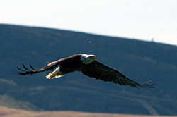
bald eagle in flight, wings stretched above body
balk eagle in flight, wings nearly horizontal

Once on the verge of extinction in the lower 48 states, the bald eagle (Haliaeetus leucocephalus) has made a remarkable comeback in California. Management programs and protective laws (most notably, a ban on the pesticide DDT) have had a profoundly positive effect on both the reproductive success and survival rate of the species. Its breeding range is rapidly expanding and today, bald eagles can be found in 42 of California’s 58 counties, rebounding from a low of eight counties in the mid-1990s.

Though the U.S. Fish and Wildlife Service removed the bald eagle from its list of threatened and endangered species in 2007, the species remains endangered under California state law, and data is constantly being gathered and analyzed to support ongoing population recovery efforts. But studying California’s eagle population is more difficult than one might think. Although reports of single eagle sightings are a useful tool for determining range expansion, they are often inconsistent and inappropriate for estimating the overall population. A better method is documenting bald eagle observations and breeding territories and monitoring them over time. To do that, CDFW relies heavily on survey data submitted by other agency partners, researchers, consultants and the general public.

According to CDFW’s Statewide Raptor Coordinator Carie Battistone, there are two ways for members of the public to contribute to this important database.

Single observations can be reported using the California Natural Diversity Data Base (CNDDB) Online Field Survey Form. This may include breeding (for example, a nest location or a pair constructing a nest) or nonbreeding (a single bird foraging or perched) observations. For all data submissions, the more information that is provided to the CNDDB on population size, site condition, threats, etc., the better.

People who have more time (or experience in long-term monitoring) should use the link opens in new windowBald Eagle Nesting Territory Survey Form (PDF). This form is typically used by observers who monitor a nest frequently during an entire breeding season (from when a pair arrives at or builds a nest to when the young fledge). The information recorded on this form allows CDFW to determine nest success and productivity. Observers take notes during each survey they conduct, including behavior, the number of adults and young seen, number of fledglings, predation events, nest conditions, etc. Observers should closely follow the survey instructions and keep their distance from the eagles so as to not disturb breeding activities.

Various other types of data are tracked in CDFW’s databases, including the coordinates of observation or nest location, land ownership, the number of nests within a territory, the nest-tree type and nest condition, the number of surveys at a territory or nest, the number of adults or sub-adults seen, the number of eggs laid, the number of young fledged, predation events associated with an observation, general behavior, and other pertinent information.

“The more information we have on nest location, behaviors and breeding activities, the easier it is for us to decipher how eagles are using their territory and what the status is at any given site,” said Battistone.

According to Battistone, 371 nest sites have been reported and entered in CDFW’s bald eagle database to date (early 1990s through 2016). This data, however, is incomplete -- not all nests are reported or known, and of the nests that are entered in the database not all are surveyed every year.

CDFW receives regular reports of bald eagle sightings throughout the state during both the breeding and nonbreeding season, and as the population continues to grow and expand it is expected the number of sightings will continue to increase.

“Because the bald eagle population seems to be increasing in California, reports of new nests are not entirely surprising,” Battistone said. “However, to get a better understanding of the extent of the population increase and expansion throughout different regions of California, it is helpful to have the most complete dataset possible. We encourage and appreciate participation from the public!”

Bald eagle photos used with permission, courtesy of Marcia Grefsrud.

Categories: Wildlife Research
CDFW Science Institute logo

Subscribe

Receive Science Institute news by email.