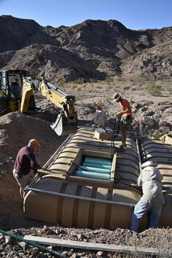
 Volunteers from the Society for the Conservation of Bighorn Sheep install the second of three 2,300-gallon water tanks to provide water for wildlife in the Southern California desert.
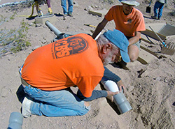 SCBS volunteer Glenn Sudmeier and Steve Marschke install plumbing fixtures for the sheep drinker at the Cady Mountains guzzler project in San Bernardino County.
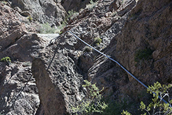 Pipes bolted into the rocks coming from a catch pond going to the original guzzler installed in the desert.
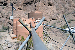 Plumbing pipes leading from the catch ponds to the storage tanks at the 40-year-old Cady # 1.
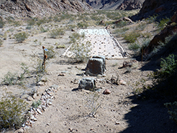
 The completed project: Drinkers are covered by fiberglass simulated rocks that shade the water to slow evaporation and to stop algae growth in the opening of the drinker.
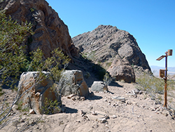
 Entire scope of the project, with the 150-foot-long catch field in the background that feeds water to the underground tanks.
One of the most elusive species in California is the desert bighorn sheep (Ovis canadensis nelsoni) that live in the dry, desert mountains of southeastern California. Desert bighorn are far from fragile – males are about five feet long and can weigh up to 200 pounds, while the females weigh up to about 150. Despite their size, their keen eyesight and the agility to escape predators up steep rocky slopes, they still face many threats, including disease, human development, expansion and – more recently—a changing climate. Water is critical to their survival in this extreme environment.
The Society for the Conservation of Bighorn Sheep (SCBS), an all-volunteer organization in Southern California, has been working since 1964 for the conservation and management of the desert bighorn sheep. Over the last 40 years, SCBS and CDFW have been installing drinking systems (also called guzzlers) across the sheep’s habitat to help counteract these challenges. Now the populations rely on these water sources to survive and there is a responsibility to keep them functional and maintained.
In September 2017, SCBS rallied the volunteers to install a new drinking system to provide sheep and other animals life-supporting water in the hot summers. The project took place in the desert east of Barstow, and began with the removal and replacement of the very first guzzler ever installed in California.
The old system had two cement catch ponds, each similar to a small swimming pool lined with plastic. The catch ponds collected rain water and funneled it though pipes and valves to three tanks, where it was stored and fed to a small stainless steel drinker box. Due to its age and condition, after being exposed to the desert air and sun for more than 40 years, the system needed constant maintenance, and – more importantly – SCBS members had to haul hundreds of gallons of water across the desert each summer in order to keep the tanks full during the hottest parts of the year.
To improve efficiency and reduce the impact on the habitat, engineers and scientists devised a new approach to the design and installation of the new system. They created a 150-foot-long catch field, laying down three sections of overlapping matting, like tiles on a roof. The mats were then covered with rocks to help it blend into the surrounding area. The mats are made of non-absorbent material that funnels water down a slope where it’s collected and fed into two 2,300-gallon plastic tanks buried in the ground.
SCBS members did all the work to design and engineer the site, dig out the large holes to bury the tanks and install the plumbing and other equipment, including a solar powered satellite telemetry system that will allow scientists to monitor the water levels, ambient temperatures, water flow and other measurements at the remote site.
After four days of morning-to-night labor, the project was completed and the site returned to its near-natural state. Most of the old system was removed with one tank still operating to give the sheep time to find the new water source about 1,000 feet away. The new system is more efficient, requires very little maintenance, and has a higher storage capacity that should eliminate water hauling efforts. The tanks provide enough water for all wildlife in the area, not just the sheep, and they are less visually intrusive from both land and the air, blending well into the desert surroundings.
All this equipment comes at a cost and this construction was paid for with a grant from the CDFW Big Game Management Account (BGMA) that provides money to fund projects that benefit big-game populations and the habitats upon which they depend.
The careful planning and work done will provide a stable and reliable water source for the sheep and other wildlife in this area for decades to come.
To watch volunteers install the new drinking system, watch a video on the CDFW YouTube channel.
Photos of installation courtesy of SCBS. CDFW photos of finished project by Andrew Hughan.