CDFW conducts coastwide (including the Channel Islands) aerial surveys of giant and bull kelp. The first aerial survey was conducted in 1989, with another survey in 1999; annual surveys began in 2002. Although CDFW strives to complete surveys every year, some years and regions were not completed due to budget constraints. Geographic Information Systems (GIS) shapefiles of the aerial kelp surveys(opens in new tab) can be found on the CDFW website as well as on MarineBIOS, a CDFW marine and coastal map viewer. Results of the aerial surveys are depicted below.
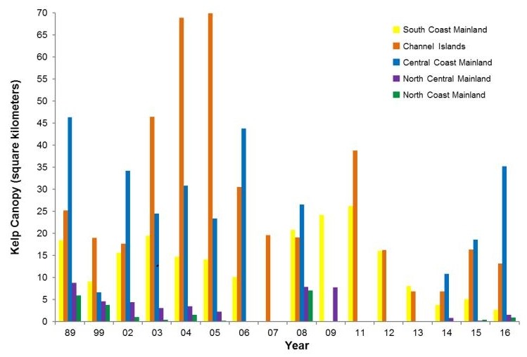 CDFW aerial kelp survey results, 1989-2016 (surveys were not conducted in all regions and years). Regions: South Coast – Point Conception to the California/Mexico border; Channel Islands - the eight Channel Islands offshore of southern California; Central Coast – Pigeon Point to Point Conception; North Central Coast – Alder Creek near Point Arena to Pigeon Point; and North Coast – California/Oregon border to Alder Creek near Point Arena.
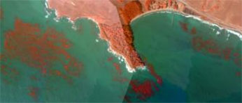 2008 aerial kelp survey at San Simeon Point, offshore of San Luis Obispo County (Administrative Kelp Beds 209 and 210). Kelp is depicted in red using the infrared band in the imagery. CDFW photo.
Further Information
-
California Department of Fish and Wildlife Aerial Kelp Surveys
- California Administrative Kelp Bed Boundaries