Science Spotlight

rss
  • July 6, 2017

Two men on a pier, one with a clipboard and the other with a fishing pole
A young woman measures a fish on a pier.
A young woman weighs a fish on a charter boat
Two men and a child fishing on a sandy beach
A young woman wearing a California Fish and Wildlife cap measures a fish on a dock

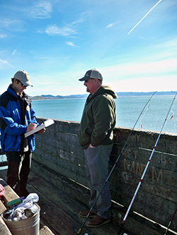
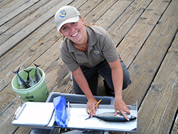
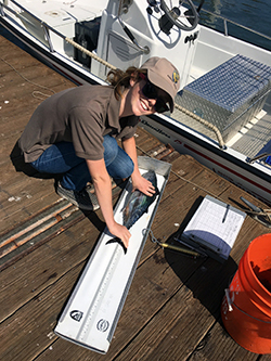
If you’re an avid marine sport angler, you have most likely seen the smiling faces and brown polo shirts of California Recreational Fisheries Survey (CRFS) samplers. Since its inception in 2004, CRFS has grown into one of the state’s largest and most important survey efforts. Survey samplers are tasked with collecting data about both recreational fishing catch and effort.

Annually, CRFS samplers make direct contact with 68,000 fishing parties at over 400 sampling sites between the California-Oregon state line to the California-Mexico border. A separate but related telephone survey effort contacts an additional 26,000 anglers. A program of this large scale is necessary because recreational fishing effort and success rates are highly dynamic – a large sample size is needed to adequately estimate catch and effort. Recreational fishing effort is also very challenging to predict, as it can be affected by many factors (weather, gas prices, time of year, fishing seasons, etc.). But the recreational sector accounts for a significant portion of overall marine harvest, so it’s essential to collect that data to produce reliable estimates of harvest.

CRFS is part of a larger effort to estimate recreational catch and effort on the west coast and is integral to the national effort conducted by the National Marine Fisheries Service’s Marine Recreational Information Program. This partnership allows CRFS methods to be periodically peer reviewed by expert consultants throughout the country. This review provides certification that the methods meet or exceed national standards and fisheries management needs, and can recommend the use of new methods to address changing needs or to capture emerging fisheries.

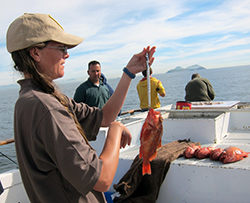
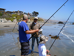
There are three parts to the survey. The first is the field sampling component. This consists of in-person interviews conducted for four different fishing modes – beaches and banks, man-made structures, private/rental boats, and commercial passenger fishing vessels. Field survey questions are specific to catch and effort data during daylight hours at publicly accessible sites. The second part of the survey is the telephone survey. Anglers are randomly selected monthly through the state’s online Automated License Data System (ALDS) and asked about effort data (the number of fishing trips taken) at beach and bank sites. The telephone survey also collects data from private boats returning to sites not sampled during the field survey, and private boats returning at night. The third part of the survey is collection of data from commercial passenger fishing vessel logs. Captains submit this information for every trip, and the data is used together with field sampling data to estimate overall fishing effort.

All of this information is used in many ways. In addition to CDFW, the Fish and Game Commission and the Pacific Fishery Management Council use the data to:

  • Track in-season catches against annual harvest limits, especially for certain over-fished groundfish species, such as Yelloweye and Cowcod rockfish.
  • Produce in-season salmon estimates in coordination with the CDFW Ocean Salmon Project.
  • Aid the development of regulations, including fishing season, bag limits, minimum size limits and depth limits.
  • Assess stocking needs for individual fish species.

How can you help? There are two ways! If you encounter a CRFS sampler in the field, please cooperate and answer the interview questions truthfully. Take the time to allow the sampler to examine and measure any catch. Recreational anglers, particularly those who fish frequently, are more likely to encounter CRFS samplers. Every fishing trip is unique — different target species, success rates, different locations, different gear, etc. — so we ask anglers, “Even if you have completed this survey before, please cooperate each time you are asked!”

Secondly, if you receive a phone call, please say “yes” to the CRFS telephone surveyor. Data collected through this telephone survey is used to estimate fishing effort that cannot be estimated any other way.

Personal contact information is always kept confidential, and the information that is collected becomes part of a public database. To learn more about the CRFS, access the database or download related flyers and brochures, please visit www.wildlife.ca.gov/Conservation/Marine/CRFS.

Categories: General
  • June 8, 2017

fingerling trout in a man's hands
Alpine lake under blue sky and mixed clouds
two boys in small boat hold two fish, each
A small building, trailer, and five trucks on an isolated hill

For generations, anglers in California’s eastern Sierra Nevada mountains fished for one of the most cherished fish in the west, the Lahontan cutthroat trout (LCT). These native beauties are prized for their size, with some growing as large as 40 pounds in the Tahoe Basin.

Sightings of these brown and red native fish have been documented as far back as 1853. But as the population of the state grew, especially during the Gold Rush, the fish were nearly wiped out by mining, development, dams, water diversion and other human factors.

Today, LCT are listed under both the State and Federal Endangered Species Acts, and CDFW has increased its commitment to angling enthusiasts by providing more opportunity to catch this historic fish. This effort includes greatly expanding the number of waters and fish planted in recent years.

Every spring, staff from the American River Hatchery in Gold River make the 100-mile journey from the hatchery to the tiny spawning buildings on the shore of Heenan Lake. This pristine body of water is surrounded by granite peaks in remote Alpine County. It is usually not accessible in the winter, cut off by the snowpack, and is only open to catch and release fishing for six weeks a year. It is also the state’s only source of LCT broodstock (groups of mature fish used as the source for eggs and reproduction). Ultimately, the 800,000 eggs spawned at Heenan Lake each year support recreational angling opportunities at multiple locations in the eastern Sierras.

The staff will make the journey up and down the mountain several times over several weeks to spawn the eggs on site. The process involves carefully bathing the eggs in iodine and suspending them in cheesecloth in aluminum jars about two feet tall, before making the journey back to Sacramento or to other state hatcheries. Some of the eggs head to destinations as far away as Filmore Hatchery in Ventura County.

Once at the hatcheries, the eggs are placed in “hatching jars,” where chilled, UV-filtered river water circulates over them continuously. After two to three weeks, the eyes of the baby fish are visible inside the eggs. These “eyed” eggs will be addled—a process in which the eggs are siphoned through a tube in order to shake them up. This causes the infertile, diseased or dead eggs to turn white, allowing hatchery technicians to easily identify, pick out and discard them. After the fry hatch, they are moved to deep tanks in the hatchery building, where they will spend approximately five months growing before being moved outdoors to large round tanks.

The fish will be planted as fingerlings or sub-catchables (fish that weigh 1/16th-1/6th of a pound) into various high-mountain waterways on the east side of the Sierras. At the time of release, they are still too small to be caught, but they will quickly grow to be trophy-sized fish for the state’s anglers who want to make the journey into the high altitudes.

Categories: General
  • May 24, 2017

A tiny transponder is placed inside the body cavity of each female salmon. When the fish lay their eggs, the transponders will be expelled, providing scientists with information on when, where and how successful each spawning female is.

a man in a CDFW uniform places a live salmon into a holding tank
After the salmon are tagged, they are returned to a holding pond while the anesthetic wears off.

a man's hands hold a large salmon in an examining trough
CDFW scientists electronically identify and perform an ultrasound on each fish in order to assess their pre-spawning condition.

man holds a salmon up
Each salmon in the project received a tiny identity tag that is entered into a database. The computerized system allows biologists to follow individual fish throughout their life cycle.

three women type on laptop computers in a tent
A team of scientists read, evaluate and record data for each individual salmon.

On Thursday, May 18, fisheries biologists implanted acoustic transponders into 60 endangered adult spring-run Chinook salmon. The transponders will track their movements and help determine spawning success later this season. The salmon will be released to spawn naturally in the San Joaquin River near Friant over the next three months.

Spring-run Chinook have been absent from the river for many decades. Reintroduction is one of multiple strategies biologists are using to reestablish naturally spawning runs of these fish as part of the San Joaquin River Restoration Project. The project – which is jointly coordinated by CDFW, the Bureau of Reclamation, the California Department of Water Resources, the U.S. Fish and Wildlife Service and the National Oceanic and Atmospheric Administration’s National Marine Fisheries Service – is a comprehensive, long-term effort to restore flows to the San Joaquin River from Friant Dam to the confluence of the Merced River and restore a self-sustaining Chinook fishery while reducing or avoiding adverse water supply impacts from restoration flows.

A total of 120 salmon will be implanted and released at two different times. Biologists will track the fish from each release to determine which is most successful. This release strategy provides the hatchery-raised salmon the opportunity to select their own mates, construct redds (a spawning nest in the stream gravel) and spawn naturally.

CDFW photos by Harry Morse

Categories: General
  • May 10, 2017

Two women hold and measure a wild sage grouse (bird)
Two women in desert with net and bird box

Five agencies in two states recently partnered to help a tiny population of Greater Sage Grouse avoid extinction along the California-Nevada border. Biologists from the California Department of Fish and Wildlife, the U.S. Fish and Wildlife Service, Los Angeles Department of Water and Power, the Bureau of Land Management and the U.S. Geological Survey are working together in this first-of-its kind study. On April 22, the bi-state team of scientists captured, inseminated, transported and released 17 of these female upland birds to a new habitat where they will hopefully flourish and repopulate. Eight male birds were also transported to Bodie Hills as part of the study.

The birds were captured near Bodie and moved to Parker Meadows, about 30 miles south. CDFW scientists have been tracking the number of Greater Sage Grouse in Parker Meadows for years, and it was evident that human intervention would be necessary to keep the group alive. Between 2002 and 2010, the number of males had dropped from about 17 to only four, and CDFW estimated that the entire population had a 70 percent chance of going extinct in the next five years.

Translocation was chosen as the best option to save them, as it would not only boost the number of birds in the area, but also immediately widen the gene pool.

The birds were captured at night, measured and radio-collared. The hens were also artificially inseminated with sperm from the males in the Bodie population before being transported and released to integrate into their new home. (link opens in new windowWatch video of the capture, insemination and release.)

Although biologists from the U.S. Geological Survey will be doing most of the hands-on work with the birds, CDFW biologists played an important role as well. Environmental Specialist Tim Taylor worked for months to obtain the proper land access permissions and assess the habitat near Bodie. Taylor identified several potential problems (including conifers, where raptors would likely perch while in search of prey, and barbed wire fencing) that needed to be removed prior to the relocation. And Senior Environmental Scientist Scott Gardner, in Sacramento, was instrumental in securing grant funding – without which, this partnership project would not have been possible.

“It’s a long term thing – it’s going to take about five years to get results we are hoping for,” Taylor said. “But we’ve got a great crew and I’m confident we’re going to have success and keep that little population going.”

Read more about the link opens in new windowGreater Sage Grouse study.

Photos by Dan Hottle/USFWS

Categories: General
  • April 18, 2017

California hosts approximately 6,500 different kinds of plants that occur naturally in the state, and many of these are found nowhere else in the world. Some of these plants are so rare or have been so impacted by human influence that they are at risk of permanent extinction from the wild and have been protected by state and federal laws. The California Department of Fish and Wildlife’s (CDFW) Native Plant Program is developing and implementing standardized and repeatable monitoring plans for ten state and federally listed plant species on nine CDFW Ecological Reserves throughout the state. This work is funded by a federal grant awarded in 2015.

a man kneels to look at wildflowers

One of the plants being monitored is Butte County meadowfoam (Limnanthes floccosa ssp. californica), which occurs at North Table Mountain Ecological Reserve, north of Oroville in Butte County. The reserve is on an elevated basalt mesa that was created by ancient lava flows and supports a rare type of vernal pool called Northern Basalt Flow Vernal Pools. There were only 498 Butte County meadowfoam plants found on the reserve this spring. The reserve also supports a high diversity of other plant species that erupt with bright colors in the spring and attract hordes of visitors.

Another plant being monitored is the endangered Slender-petaled thelypodium (Thelypodium stenopetalum) that occurs at Baldwin Lake Ecological Reserve, in the San Bernardino Mountains near Big Bear. The reserve is in a unique environment known as the pebble plains, which only occur in Big Bear Valley and nearby Holcomb Valley. The pebble plains were formed when glaciers receded during the Pleistocene age and mainly consist of clay soils overlain by a layer of orange and white quartzite pebbles. Slender-petaled thelypodium only grows in this rare pebble plain habitat, and only 15 plants were found on the reserve last spring. Other rare plant species such as the endangered bird-foot checkerbloom (Sidalcea pedata) are found on the reserve and in the surrounding pebble plain habitat.

The monitoring project also includes plants at Little Red Mountain, Boggs Lake, Loch Lomond, Stone Ridge, Phoenix Field, Pine Hill and Apricum Hill Ecological Reserves. The grant is funded through January 2018 and the Native Plant Program has applied for another grant to continue this project.

Categories: General
CDFW Science Institute logo

Subscribe

Receive Science Institute news by email.