Science Spotlight

rss
  • August 8, 2018

Map of area around Los Padres National Forest, showing where the bear tilapia
This CDFW map shows the routes
and distances traveled by both bears
since being re-released in January.


A light brown bear with a black muzzle sits on a green tarp in the bed of a navy blue pickup truck.
The older bear, safely on her way
back to the wilderness after being
tranquilized in Montecito by a wildlife
officer on April 2. (CDFW photo)

We have an update on the two black bears that were burned in the Thomas Fire in late December/early January! Both bears were suffering from extensive burns to their paws when they were brought to CDFW’s Wildlife Investigations Lab in northern California. Under the care of CDFW Senior Wildlife Veterinarian Dr. Deana Clifford and Dr. Jamie Peyton of the UC Davis Veterinary Medical Teaching Hospital, the bears were given an unusual experimental treatment involving the use of sterilized tilapia skins as bandages. After the bears were well enough to survive on their own, they were returned to the Los Padres National Forest, as near as possible to where they were originally found. Both have covered many miles and each has been spotted at least once since their release.

The younger bear was seen in an avocado orchard on May 29 by a biological consultant conducting a bird nesting survey. The bear ran away, which is a good sign that she has not become habituated. The consultant was able to get photos and video of the bear, who appears to be in good physical shape.

The older bear, who was pregnant during treatment and at the time of her release in January, came down from the hills and wandered into the town of Montecito on April 2. A local wildlife officer tranquilized her and returned her to suitable habitat, and she’s stayed away from people ever since. Though she was reportedly in good general health, there has been no sign of a cub, so the pregnancy may not have been carried to term or the cub may not have survived.

GPS collars on the bears allow CDFW biologists to track the animals’ movements so they can see where each one has been. Data shows the younger bear usually stays near Fillmore, but has made the 10-mile trek back to her release site in the Sespe Wilderness Area at least three times. She also made a brief trip over to Highway 5, north of Castaic. The older bear spends most of her time in the hills above Ojai. “We are encouraged and so pleased that both bears have survived for eight months now after burn treatment and release – they have walked hundreds of miles on their treated feet by now,” Dr. Clifford said.

CDFW will continue to monitor the movements of both bears via their satellite collars for at least another year. The data will ultimately help scientists build their knowledge of how animals utilize landscapes affected by large fires.

Read the original story of the Tilapia Bears at: https://tinyurl.com/y849mru7

Top photo: The younger of the two bears, as seen in an avocado orchard on May 29. (Photo by Jessica West)

Categories: General
  • March 23, 2018

A brownish-green river with a glassy surface flows through semi-arid land as two men fish from the rocky shore
Surveying Ventura River in Ventura County

A person in a black, full-body wetsuit floats, face-down, in a clear, shallow stream lined by forest and riparian vegetation
Snorkel survey in Hollow Tree Creek in Mendocino County

A young steelhead trout is barely visible, camouflaged against greenish-golden rocks in a stream
Hollow Tree Creek steelhead

Taking care of California’s fish and wildlife wouldn’t be possible without managing the resources upon which they depend. To that end, CDFW has an entire branch – and many scientific staff – dedicated to the scientific study, and planning and management of water resources.

Within the Water Branch, CDFW’s Instream Flow Program (IFP) is tasked with collecting and contributing data necessary to make all kinds of important management decisions about ecological function, fish rearing, spawning and migration and habitat suitability.

In the simplest terms, “instream flow” refers to the rate of the water running through a waterway in a natural environment. But when one considers all the interests competing for use of that water – fisherman, boaters, farmers, businesses, water districts, and fish and wildlife themselves – the complexity of the subject is evident.

Measured in cubic feet per second (cfs), instream flow can be measured at different times of the year in a specific location in a waterway. The fluctuations can tell scientists quite a bit about the ecosystem health of a watershed. While some watersheds have flowing water throughout the year and others are intermittent it is often the responsibility of water managers to distribute the water between uses. CDFW, a natural resource management agency, is faced with the complex task of identifying and recommending instream flows necessary for supporting natural resources. Determining instream flows are crucial so that aquatic, riparian, and terrestrial resources dependent on water will be considered and protected during water distribution activities.

Guided by the California Water Action Plan, the Public Resources Code and the Fish and Game Code, IFP staff conduct flow studies, collect field data, develop guidelines for quality assurance, conduct outreach and coordinate with other agencies and interested parties on program-related activities.

In the past year, some of IFP staff’s largest projects have included:

  • A flow study at the South Fork of the Eel Watershed, which supports threatened coho, Chinook and steelhead.
  • A study of 46 coastal steelhead streams (Ventura County to Siskiyou County) to develop flow criteria and evaluate historic flow trends.
  • A flow study to identify flow regimes that will protect endangered Southern California steelhead in the Ventura River.
  • Technical studies and final flow recommendations based upon the needs of South-Central Coast steelhead in Monterey County’s Big Sur River.
  • Ongoing training for IFP staff, to ensure that field studies in swift water are carried out safely.

To learn more about these specific projects, please download the link opens in new windowIFP’s 2017 Year in Review (PDF) document, available on CDFW’s website.

A Featured Scientist Q&A with the IFP manager Robert Holmes is also available on the CDFW Science Institute page.

CDFW photos. Top photo: IFP staff hold a planning meeting prior to a survey on the Ventura River in Ventura County

Categories: General
  • March 20, 2018

A young woman with a rectangular wire cage containing two trapped, brown doves
Two doves in a backyard wire trap

A woman's right hand holds a dove's right wing outstretched
A bander holds out a dove’s wing to see which feather has most recently molted, which will provide information about the age of the bird.

A brown and gray dove with a silver band on its leg is held outdoors in a woman's hand
A volunteer trapper prepares to release a banded female.

If you have an interest in migratory upland birds – as a hunter, a birdwatcher or just a citizen scientist – there’s a unique volunteer opportunity coming up that will allow you to work hands-on with wildlife, while helping the California Department of Fish and Wildlife collect critical research data that will become part of a national database.

Approved volunteers will be specifically trained over the next few months and permitted to capture mourning doves for a seven-week period, from July 1 through August 20, 2018. Banders attach a metal leg band to each bird, determine the bird’s age and sex , and record the data before releasing the bird. Banders can choose their own trapping sites, which in many cases are on their own property.

CDFW is particularly in need of volunteers in North Coast and Bishop areas, but as this is a statewide program, volunteers from other areas may be able to participate as well.

“It’s a unique opportunity for wildlife enthusiasts to get hands-on experience and play an important role in the management of California’s number one game bird,” explains Karen Fothergill, an environmental scientist and coordinator of CDFW’s Mourning Dove Banding Program.

Several levels of participation are possible, but successful completion of a four-hour training session is mandatory for all participants. Trained volunteers will band in their local areas, ending 10 days prior to the start of the hunting season for mourning doves.

The imprinted bands that are attached to birds’ legs are an important tool used by wildlife managers to help them evaluate mourning dove populations. Band recovery data is incorporated into the US Geological Survey Bird Banding Laboratory database and used by wildlife managers to monitor the status of mourning dove populations.

Together, the volunteer force will band approximately 4,000 mourning doves around the state. This number – which is necessary for accurate population modeling – has only been achieved with the use of volunteers.

Volunteer training opportunities will be held around the state, depending on how many potential volunteers show interest in participating, and where those individuals are located. Fothergill said that she expects to hold at least four training opportunities in the month of May. For scheduling purposes, potential volunteers are asked to contact Fothergill no later than April 13.

Volunteers are not compensated, but all supplies will be loaned at no charge.

Program participants must be over 18 and have good organizational skills and a commitment to wildlife preservation. The trapping and banding work is typically done in the morning and evening, but volunteers who can only work limited hours or on certain days can still be utilized and are welcome. For more detailed information about the program or to reserve a space at a training session, please contact Karen Fothergill at (916) 716-1461 or Karen.Fothergill@wildlife.ca.gov.

CDFW photos.
Top Photo: Mourning dove (Zenaida macroura)

Categories: General
  • March 9, 2018

map of Battle Creek watershed area

Habitat is the key to the long-term survival of Sacramento River winter-run Chinook in California. Since 1999, CDFW has been working with multiple agencies and private parties on planning efforts to restore the population of these endangered salmon. More than $100 million has been allocated to specific habitat restoration work on Battle Creek, which comprises approximately 48 miles of prime salmon and steelhead habitat.

Over the next two months, link opens in new windowapproximately 200,000 juvenile winter-run Chinook will be released into the North Fork of Battle Creek. The introduction of these fish, which were spawned from adults last summer, is occurring sooner than expected due the availability of fish from the Livingston Stone National Fish Hatchery Winter-run Chinook Captive Broodstock Program. The fish were raised at Coleman National Fish Hatchery and are being released by Coleman Hatchery personnel. These additional fish could help bolster the winter-run Chinook population and be a potential catalyst in their recovery.

CDFW Senior Environmental Scientist Doug Killam has worked on the Battle Creek Reintroduction Plan for nearly a decade and has been instrumental in moving in-stream projects forward. Killam sees the release of 200,000 smolts as an important step in the overall effort. The release will reestablish winter-run Chinook in a new drainage and create a separate new population. Currently there is only one viable population existing in the Sacramento River directly below Keswick and Shasta Dams. The recent drought affected the volume of the critical cold-water pool in Shasta Lake and the release of warmer water in the drought years of 2014 and 2015 resulted in major losses to eggs and young salmon below the dam. Biologists have long recognized that having more than one winter-run Chinook population is imperative for the long-term survival of the species.

A volcanic region with rugged canyons and dramatic scenery, the North Fork of Battle Creek is unique since it has both cold snowmelt water and large amounts of spring water flowing into it at critical times for winter-run salmon to hold over in and spawn in. It is also one of a handful of waters that can support all four of the Chinook salmon runs that return to the Sacramento River Basin. Hydroelectric development of the creek in the early 1900s largely eliminated winter-run Chinook and other salmonid runs from swimming far upstream to access the cooler water required for these unique summer spawning salmon. Recent efforts to bring the fish back to the North Fork include dam removals, rock fall removal, new fish ladders and fish screens and – most importantly – an agreement to increase stream flows to provide fish with the water quantity and quality they need to survive and thrive in this important keystone stream.

CDFW photo by Heather McIntire. Map by CDFW Fisheries Branch.

Categories: General
  • February 28, 2018

A trap made of small logs covered with pine and fir fronds is camouflaged in the snow between two tree trunks.
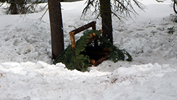
Camouflaged trap used to capture foxes for the study. CDFW photo by Jennifer Carlson.

A bright orange, bushy-tailed fox runs in snow toward dense forest
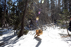
Sierra Nevada red fox bounds back to its native habitat after capture and study. CDFW photo by Scientific Aide Corrie McFarland.

The Sierra Nevada red fox has been the subject of intensified study by CDFW over the past decade. As they are notoriously tough to track and even tougher to trap, there are many unanswered questions regarding this elusive animal.

In an effort to better understand this state-listed threatened species, an ongoing research project seeks to capture and affix GPS tracking collars to them. The data collected will help biologists better understand the size and characteristics of the fox’s home range, its denning and resting areas, and its foraging habits.

The species has been outfoxing researchers for some time -- to the point where in the 1980s, it was presumed to have vanished forever from its historically occupied habitat in the Cascade and Sierra Nevada ranges. In March 1993, thanks to the then-emerging technology of infrared trail cameras, US Forest Service employees detected a single red fox in the Lassen National Forest.

That discovery prompted a wider study of foxes and other meso-carnivores in and around Lassen Volcanic National Park. In the late 1990s and early 2000s, Dr. John Perrine of the University of California, Berkeley, captured five individuals, primarily in the park, and placed radio collars on them to study their home range (both summer and winter), food habits and resting sites. Unfortunately, two of the collared individuals died within a year and none of the females reproduced during the course of the study.

Years later, CDFW launched a new study to determine the foxes’ current distribution in northern California and to address potential impacts on the species from activities including recreation and timber harvest. Initial efforts in 2008 used scat-detector dogs to survey portions of Lassen Volcanic National Park and the adjacent Caribou Wilderness. Then, from 2009 to 2011, trail cameras and hair-snaring devices were employed to survey high-elevation habitats in the Cascade Range from Mount Shasta to Lassen Peak. Yet foxes were only detected in the Lassen Peak area.

CDFW biologists have continued to survey for foxes with trail cameras, hair-snaring devices and scat surveys. Scats and photos are often obtained along Lassen Volcanic National Park and Forest Service hiking trails, because, like many other animals, red foxes frequent trails as they move through their territories. Analysis of the DNA contained in the collected scats and hair identified 22 individuals from 2007-2016. Some of these foxes are long-lived – samples collected over time from the same individual indicate that five of those individuals lived at least five and a half years.

CDFW efforts to capture and collar Sierra Nevada red foxes since 2013 were unsuccessful – until early February 2018. The nearly two decade-long dry spell came to an end at last when CDFW captured a Sierra Nevada red fox, a male that weighed about 10 pounds. It was captured in a “log cabin” style trap on National Forest land just outside of Lassen Volcanic National Park, near the town of Mineral. The fox was collared and released at the capture location, and CDFW biologists have been impressed by the distances he has regularly been covering since (five to six miles per day) despite the rough terrain and high elevation.

“Persistence played a large role in our success, because there are many days when we do not have any fox detections,” said CDFW Wildlife Biologist Jennifer Carlson. “We also ramped up our efforts this year by hiring two scientific aids rather than just one, which allowed us to literally double our efforts by putting more traps out across the study area.”

CDFW hopes to capture as many as four more red foxes this year. Scientists are using box traps, cage traps and a “log cabin” style trap that researchers have used in other states to capture both red foxes and wolverines. Capturing foxes is not an easy task given the cold temperatures and snowstorms, but as the Lassen population may only consist of around 20 individuals, it is imperative for the department to learn as much as it can about this stealthy animal.

For more information, please visit the Sierra Nevada red fox page.

Top photo: Senior Environmental Scientist Pete Figura and Senior Wildlife Veterinarian Deana Clifford release a red fox study subject. CDFW photo by Corrie McFarland

Categories: General
CDFW Science Institute logo

Subscribe

Receive Science Institute news by email.