Science Spotlight

rss
  • April 12, 2018

CDFW wants to know if, when and where you’ve seen an elk in California – and they’ve just created a new online reporting tool that makes it easy for members of the public to share this information.

CDFW scientists will use the raw data to help guide their efforts to study statewide elk distribution, migration patterns and herd movement, population size estimates, habitat use, health and diseases, and causes of mortality.

“We have limited resources and our scientists cannot scan the entire landscape,” explained CDFW Senior Environmental Scientist Pete Figura. “This tool provides a way for us to leverage the many sightings of the wildlife-watching public. People often get excited when they see elk, and hopefully now they will channel that excitement by reporting the location and time of their sighting to our department.”

There are three subspecies of elk in the state – tule, Rocky Mountain and Roosevelt -- and all three have expanded their range in recent years according to Figura.

CDFW has elk studies underway in the northern part of the state: one is focused on Roosevelt elk in Humboldt and Del Norte counties, and the other is focused on elk in Siskiyou and Modoc counties. Tracking and studying such a large mammal is a complex undertaking as elk herds are wide-ranging, and often graze and browse in areas that are not easily accessible, and there are only so many scientists to monitor their movements.

The launch of the reporting tool is just the latest effort to enhance the management of elk in California. Last year CDFW released a public draft of the Statewide Elk Conservation and Management Plan that addresses historical and current geographic range, habitat conditions and trends, and major factors affecting elk in California.

The plan will provide guidance and direction for setting priorities for elk management efforts statewide. CDFW is reviewing public comments on the plan and will incorporate appropriate changes into the final document prior to its release, which is expected soon.

CDFW Wildlife Branch Chief Kari Lewis has termed the plan an “important milestone” and explained that public feedback is a critical part of shaping the effort, which emphasizes a sharing of resources and collaboration with all parties interested in elk and elk management. This, she said, is essential to effectively managing California’s elk populations.

For more information about elk in California, please visit CDFW’s elk management webpage.

CDFW File Photo. Top photo: Group of Tule Elk.

# # #

Categories: General
  • April 6, 2018

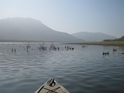
Bow of kayak floating on calm lake with foggy mountains in background
Brush habitats were created and put into Lake Perris to provide fish with habitat to feed and reproduce. The habitats will be completely submersed when the lake is filled to capacity.
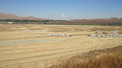
Barren earth with large piles of large rocks distributed throughout
The exposed lakebed gave CDFW fisheries biologists the opportunity to safely construct different kinds of habitat for the fish in Lake Perris.
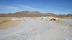
Landscape covered in gravel and piles of large rocks
Rock Reefs and Spawning gravel areas have been created and placed in more than 100 places around Lake Perris that will be utilized once the lake is returned to full capacity.
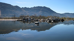
Calm lake facing a pile of large rocks partially submerged with mountains in the background
Rock Reefs constructed along the shore of Lake Perris, most about 1,000 square feet provide cover for juvenile fish and forage species.
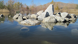
Lake with partially submerged pile of rocks with trees and mountain in the background
135 Pipe Caves were constructed from PVC pipe and will provide spawning habitat for catfish.
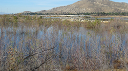
Landscape of lake with overgrown vegetation in foreground, land peninsula with piles of large rocks in midground, and trees and mountains in background
Biologists created about 1,500 brush habitats in hundreds of locations on the banks of Lake Perris and in accessible locations further into the lake.
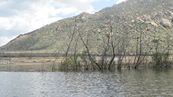
lake with partially submerged vegetation and mountain in the background
Biologists created about 1,500 brush habitats in hundreds of locations on the banks of Lake Perris and in accessible locations further into the lake.

More than a decade ago, Southern California freshwater anglers were disappointed to see a tried-and-true fishing spot dramatically affected by an emergency lake drawdown. Due to seismic concerns with the Perris Dam, California Department of Water Resources (DWR) officials deemed it necessary to reduce the water level at Lake Perris near Riverside by several thousands of acre-feet.

The drawdown exposed about 25 feet of bank around the perimeter of the lake. Since water was not going to be available for years while the dam was assessed and repaired, CDFW embarked upon a fisheries habitat mitigation project (funded by DWR) to create new fish habitat in the remaining water and the now exposed lakebed.

The project had two phases. The first was to immediately create fisheries habitat in the drawn-down portion of the lake in order to maximize use of the remaining water. The second was to build new habitats on the temporarily exposed areas, with the hope of benefitting both sport-fish species and anglers when the lake is eventually refilled. 

After 12 years, both phases are nearly completed.

After the initial water level reduction, teams from CDFW and DWR began working to prevent the immediate collapse of the lake’s fishery. The initial work, which took three years, involved the creation and placement of about 400 fish habitats made of recycled Christmas trees and citrus limbs. The man-made shelters ensured the fish would have places to hide and reproduce.

After the initial triage, CDFW biologists began to place additional habitats into the remaining water of Lake Perris. These habitats, made of thousands of tree trunks, citrus limbs and whole tree stumps would eventually give the lake’s fish an additional 1,500 refuges for safety. 

The citrus limbs were drilled with a ½” hole in the base and multiple limbs were tied together as compactly as possible and attached to a concrete block with polypropylene ropes to weigh them down. They were then placed strategically in different parts of the lake. These citrus habitats should provide cover for the warm water fish for at least 10 - 15 years.

Due to their bulk, increased buoyancy and weight, the single tree stumps were placed individually around the lake and weighted down with concrete blocks to keep them anchored.

Because the lake will be refilled to capacity once dam repairs are complete, it is important that the scientists are able to carefully track each habitat location. They worked in quadrants, placing 20 - 60 bundles into each to create “communities.” The grouped communities increase localized productivity of the warm water fish native to the lake and contribute to maintaining the warm water fisheries while the lake is in its reduced capacity. Each of the quadrant’s corners was marked with GPS, enabling scientists to record and monitor data specific to each location. 

The second phase of the project was the implementation of a Fishery Habitat Plan for the exposed lakebed above the drawn-down area. The implementation of the plan is a requirement of the Lake and Streambed Alteration Agreement between CDFW and DWR.

As with the below-water work that had already been completed, CDFW scientists carefully planned what kinds of habitat to create, what materials to use and where to place them in the open, exposed lakebed in order to provide the best environments for fish when the lake was fully restored. Areas were selected for habitat placement based on accessibility, proximity to existing natural habitat directly affected by the water reduction, avoidance of areas utilized for construction activities, distance from swimming areas and consideration of boating hazards.

Multiple types of habitats were designed and installed in Lake Perris, including:

  • Brush habitats. Similar to the citrus branch habitats already placed in phase one, these brush habitats add to the terrestrial vegetation growth that has thrived in the lakebed since initial triage efforts began in 2006.
  • Pipe caves constructed from 12” diameter PVC pipes. Approximately 4 feet long and capped at one end with concrete, these will provide spawning habitat for catfish that was lost when the lake was drawn down. A total of 135 pipe caves were placed around the rock reefs and terrestrial vegetation and will allow the young catfish to disperse into favored rearing habitat.
  • Rock reefs were created from 226 dump truck loads of material stockpiled by DWR from a nearby rock quarry. These rock piles cover about 110,000 square feet of the lakebed -- about the size of two football fields. Staff created 109 rock reefs, each about 1,000 square feet (about the size of an average home lot). These provide cover for juvenile fish and forage species (such as crayfish) as well as spawning habitat and foraging areas for adult fish. Their placement is designed to allow fish to transition from deeper waters to shallower waters -- and vice-versa -- when the lake returns to normal operating levels.
  • Spawning gravel areas. Thirty of these were created from suitable bottom composition for sunfish, bass, bluegill, etc. to spawn on and around. Almost 200,000 square feet of gravel bed habitat are now in the shallowest areas of the lake, adjacent to rock reefs or terrestrial vegetation that will be covered once the lake refills.

    After years of cooperative work Lake Perris is nearly ready to be refilled and with the thousands of new and improved habitats local anglers will be shouting “fish on” for decades to come. 

CDFW Photos. Top Photo: Citrus tree stumps, weighted down with concrete blocks to keep them anchored were placed individually around Lake Perris to create small habitats called communities.

# # #

Categories: General
  • March 23, 2018

A brownish-green river with a glassy surface flows through semi-arid land as two men fish from the rocky shore
Surveying Ventura River in Ventura County

A person in a black, full-body wetsuit floats, face-down, in a clear, shallow stream lined by forest and riparian vegetation
Snorkel survey in Hollow Tree Creek in Mendocino County

A young steelhead trout is barely visible, camouflaged against greenish-golden rocks in a stream
Hollow Tree Creek steelhead

Taking care of California’s fish and wildlife wouldn’t be possible without managing the resources upon which they depend. To that end, CDFW has an entire branch – and many scientific staff – dedicated to the scientific study, and planning and management of water resources.

Within the Water Branch, CDFW’s Instream Flow Program (IFP) is tasked with collecting and contributing data necessary to make all kinds of important management decisions about ecological function, fish rearing, spawning and migration and habitat suitability.

In the simplest terms, “instream flow” refers to the rate of the water running through a waterway in a natural environment. But when one considers all the interests competing for use of that water – fisherman, boaters, farmers, businesses, water districts, and fish and wildlife themselves – the complexity of the subject is evident.

Measured in cubic feet per second (cfs), instream flow can be measured at different times of the year in a specific location in a waterway. The fluctuations can tell scientists quite a bit about the ecosystem health of a watershed. While some watersheds have flowing water throughout the year and others are intermittent it is often the responsibility of water managers to distribute the water between uses. CDFW, a natural resource management agency, is faced with the complex task of identifying and recommending instream flows necessary for supporting natural resources. Determining instream flows are crucial so that aquatic, riparian, and terrestrial resources dependent on water will be considered and protected during water distribution activities.

Guided by the California Water Action Plan, the Public Resources Code and the Fish and Game Code, IFP staff conduct flow studies, collect field data, develop guidelines for quality assurance, conduct outreach and coordinate with other agencies and interested parties on program-related activities.

In the past year, some of IFP staff’s largest projects have included:

  • A flow study at the South Fork of the Eel Watershed, which supports threatened coho, Chinook and steelhead.
  • A study of 46 coastal steelhead streams (Ventura County to Siskiyou County) to develop flow criteria and evaluate historic flow trends.
  • A flow study to identify flow regimes that will protect endangered Southern California steelhead in the Ventura River.
  • Technical studies and final flow recommendations based upon the needs of South-Central Coast steelhead in Monterey County’s Big Sur River.
  • Ongoing training for IFP staff, to ensure that field studies in swift water are carried out safely.

To learn more about these specific projects, please download the link opens in new windowIFP’s 2017 Year in Review (PDF) document, available on CDFW’s website.

A Featured Scientist Q&A with the IFP manager Robert Holmes is also available on the CDFW Science Institute page.

CDFW photos. Top photo: IFP staff hold a planning meeting prior to a survey on the Ventura River in Ventura County

Categories: General
  • March 20, 2018

A young woman with a rectangular wire cage containing two trapped, brown doves
Two doves in a backyard wire trap

A woman's right hand holds a dove's right wing outstretched
A bander holds out a dove’s wing to see which feather has most recently molted, which will provide information about the age of the bird.

A brown and gray dove with a silver band on its leg is held outdoors in a woman's hand
A volunteer trapper prepares to release a banded female.

If you have an interest in migratory upland birds – as a hunter, a birdwatcher or just a citizen scientist – there’s a unique volunteer opportunity coming up that will allow you to work hands-on with wildlife, while helping the California Department of Fish and Wildlife collect critical research data that will become part of a national database.

Approved volunteers will be specifically trained over the next few months and permitted to capture mourning doves for a seven-week period, from July 1 through August 20, 2018. Banders attach a metal leg band to each bird, determine the bird’s age and sex , and record the data before releasing the bird. Banders can choose their own trapping sites, which in many cases are on their own property.

CDFW is particularly in need of volunteers in North Coast and Bishop areas, but as this is a statewide program, volunteers from other areas may be able to participate as well.

“It’s a unique opportunity for wildlife enthusiasts to get hands-on experience and play an important role in the management of California’s number one game bird,” explains Karen Fothergill, an environmental scientist and coordinator of CDFW’s Mourning Dove Banding Program.

Several levels of participation are possible, but successful completion of a four-hour training session is mandatory for all participants. Trained volunteers will band in their local areas, ending 10 days prior to the start of the hunting season for mourning doves.

The imprinted bands that are attached to birds’ legs are an important tool used by wildlife managers to help them evaluate mourning dove populations. Band recovery data is incorporated into the US Geological Survey Bird Banding Laboratory database and used by wildlife managers to monitor the status of mourning dove populations.

Together, the volunteer force will band approximately 4,000 mourning doves around the state. This number – which is necessary for accurate population modeling – has only been achieved with the use of volunteers.

Volunteer training opportunities will be held around the state, depending on how many potential volunteers show interest in participating, and where those individuals are located. Fothergill said that she expects to hold at least four training opportunities in the month of May. For scheduling purposes, potential volunteers are asked to contact Fothergill no later than April 13.

Volunteers are not compensated, but all supplies will be loaned at no charge.

Program participants must be over 18 and have good organizational skills and a commitment to wildlife preservation. The trapping and banding work is typically done in the morning and evening, but volunteers who can only work limited hours or on certain days can still be utilized and are welcome. For more detailed information about the program or to reserve a space at a training session, please contact Karen Fothergill at (916) 716-1461 or Karen.Fothergill@wildlife.ca.gov.

CDFW photos.
Top Photo: Mourning dove (Zenaida macroura)

Categories: General
  • March 9, 2018

map of Battle Creek watershed area

Habitat is the key to the long-term survival of Sacramento River winter-run Chinook in California. Since 1999, CDFW has been working with multiple agencies and private parties on planning efforts to restore the population of these endangered salmon. More than $100 million has been allocated to specific habitat restoration work on Battle Creek, which comprises approximately 48 miles of prime salmon and steelhead habitat.

Over the next two months, link opens in new windowapproximately 200,000 juvenile winter-run Chinook will be released into the North Fork of Battle Creek. The introduction of these fish, which were spawned from adults last summer, is occurring sooner than expected due the availability of fish from the Livingston Stone National Fish Hatchery Winter-run Chinook Captive Broodstock Program. The fish were raised at Coleman National Fish Hatchery and are being released by Coleman Hatchery personnel. These additional fish could help bolster the winter-run Chinook population and be a potential catalyst in their recovery.

CDFW Senior Environmental Scientist Doug Killam has worked on the Battle Creek Reintroduction Plan for nearly a decade and has been instrumental in moving in-stream projects forward. Killam sees the release of 200,000 smolts as an important step in the overall effort. The release will reestablish winter-run Chinook in a new drainage and create a separate new population. Currently there is only one viable population existing in the Sacramento River directly below Keswick and Shasta Dams. The recent drought affected the volume of the critical cold-water pool in Shasta Lake and the release of warmer water in the drought years of 2014 and 2015 resulted in major losses to eggs and young salmon below the dam. Biologists have long recognized that having more than one winter-run Chinook population is imperative for the long-term survival of the species.

A volcanic region with rugged canyons and dramatic scenery, the North Fork of Battle Creek is unique since it has both cold snowmelt water and large amounts of spring water flowing into it at critical times for winter-run salmon to hold over in and spawn in. It is also one of a handful of waters that can support all four of the Chinook salmon runs that return to the Sacramento River Basin. Hydroelectric development of the creek in the early 1900s largely eliminated winter-run Chinook and other salmonid runs from swimming far upstream to access the cooler water required for these unique summer spawning salmon. Recent efforts to bring the fish back to the North Fork include dam removals, rock fall removal, new fish ladders and fish screens and – most importantly – an agreement to increase stream flows to provide fish with the water quantity and quality they need to survive and thrive in this important keystone stream.

CDFW photo by Heather McIntire. Map by CDFW Fisheries Branch.

Categories: General
CDFW Science Institute logo

Subscribe

Receive Science Institute news by email.