Science Spotlight

rss
  • May 31, 2019

Large blue mat framed into 3 sections with black and orange rope handle on side.
A new egg mat prior to deployment (CDFW photo by Marc Beccio)

Water with orange balls floating.
Sturgeon egg mats deployed in a local waterway (CDFW photo by Marc Beccio)

Brown, dirty, rusted mat with dozes of small round eggs spread out over mat.
Egg mats with Green Sturgeon eggs (CDFW photo by Marc Beccio)

CDFW biologists have been taking a new approach to looking at reproduction in one of the oldest fish species in existence.

Green sturgeon, which are listed as threatened under the Federal Endangered Species Act, are in effect a living fossil, having swam in both the fresh and ocean waters from California to Alaska for more than 200 million years.

They are a very slow-growing fish, typically living 60 to 70 years and reaching lengths of seven feet and weights of up to 350 pounds. Little is known about where they spawn in the Central Valley and how successful they are when they spawn.

In the spring of 2017, CDFW biologists began deploying egg mats in various rivers in the Sacramento Valley. In 2018, they documented green sturgeon spawning in the Yuba River for the first time, finding approximately 270 green sturgeon eggs on an egg mat deployed immediately below Daguerre Point Dam in Yuba County.

The egg mats consist of 3.5-foot by 2.5-foot metal frames that weigh about 20 pounds and are filled with a material similar to that used for a furnace filter. Mats are deployed by being gradually lowered to the river bottom from the bow of a boat. They are then retrieved by slowly hauling in the float line to avoid dislodging eggs stuck on the mat.

Unlike salmon and trout which dig redds and cover their eggs with gravel, green sturgeon females “broadcast” (release) their eggs into the water, which then sink to the river bottom, where their sticky surfaces adhere to various objects. Of eight egg mats deployed in the pool below Daguerre Point Dam, the biologists collected 270 eggs from just a single mat. As spawning locations can be difficult to identify, and eggs can be distributed broadly by the current within individual locations, documenting this spawning event was important.

A subsample of 33 eggs was retained to determine the developmental stage which will be used to calculate a spawning date. The mat was then lowered back to the river bottom. The 33 eggs collected represent about 0.02 percent of the total produced by a female green sturgeon of average size.

After confirming the presence of adult green sturgeon in the Yuba River, CDFW biologists believe the river may be important habitat for the species. Further research using these egg mats over the next several years will help fisheries managers identify critical spawning locations and habitat requirements for the future protection and enhancement of the species.

CDFW Photos. Top Photo: Green Sturgeon underwater. CDFW photo by Mike Healey.

###

Media Contact:
Kyle Orr, CDFW Communications, (916) 322-8958

Categories: Wildlife Research
  • October 19, 2018

Closeup shot of salmon fin
Close-up of adult spring-run Chinook salmon dorsal fin.

Close up shot of salmon with mouth open wide while held in hand
Adult spring-run Chinook salmon inform river restoration decisions by their habitat use and preferences.

Man wearing khaki colored waders, grey short sleeve shirt, orange vest and green CDFW baseball cap standing in water bent over holding salmon. Two other people standing in background.
Adult spring-run salmon are carefully selected for release based on their sexual maturity.

Salmon with blue tracking device held above white net over water
Spring-run Chinook salmon released into the San Joaquin River are outfitted with three tags including a colored T-bar tag for visual identification.

Fresno County may seem an unlikely setting for salmon restoration and research, but some of the California Department of Fish and Wildlife’s (CDFW) most ambitious work with salmon anywhere is taking place in the heart of the parched Central Valley.

Since September, CDFW fisheries biologists have been spawning spring-run Chinook Salmon broodstock in the shadow of Friant Dam on the San Joaquin River. This season, CDFW staffers spawned 100 mature females that ranged in age from 3 to 6 years old  producing about 290,000 eggs.

It’s all part of an unprecedented, multiagency effort to restore an extinct, spring-run Chinook Salmon run to the San Joaquin River that is happening alongside river restoration efforts to make the river more salmon-friendly for a fish listed as threatened under both the state and federal Endangered Species Act.

Historically, spring-run Chinook Salmon were the most abundant salmon species in the Central Valley. Today, there are so few fish broodstock used for spawning comes from eggs collected at CDFW’s Feather River Hatchery in northern California. Meanwhile, construction is underway on a spring-run Chinook Salmon hatchery at the base of Friant Dam to support future runs of San Joaquin River salmon. The hatchery is scheduled to be completed in 2019.

During spawning, each female is crossed with four males to maximize genetic diversity. Samples of ovarian fluid are collected and sent to the CDFW’s Fish Health Lab for virology and bacterial analyses. Any egg lots determined to be potentially infected with pathogens are excluded from CDFW’s captive rearing program.

In June and August, 179 captive-reared adult fish – 59 females and 120 males – were released into the San Joaquin River to monitor what parts of the river the salmon prefer for holding and natural spawning.

Prior to release, each fish was outfitted with three tracking devices – an electronic passive integrated transponder (PIT) tag for individual identification, a colored, T-bar tag for visual identification, and an acoustic transmitter so their movements in the river can be monitored and recorded. Their habitat use and preferences inform river restoration efforts.

Spring-run Chinook Salmon spawn in the fall from mid-August through early October. So far, biologists have found 37 constructed redds – or salmon nests – in the San Joaquin River indicating some of the released salmon found enough cool water in the heavily damned and diverted river system to survive the Central Valley’s furnace-like summer and are now actively spawning in the river.

CDFW Photos by Travis VanZant. Top Photo: Prior to their release into the San Joaquin River this past summer, adult spring-run Chinook salmon were outfitted with acoustic transmitters so their movements in the river can be monitored and recorded.

Categories: Wildlife Research
  • April 20, 2018

Man in Department of Fish and Wildlife uniform standing in the bed of a truck shoveling rocks

Man in Department of Fish and Wildlife uniform standing in stream pouring rocks into stream from large bucket

Man in Department of Fish and Wildlife uniform crouching in stream looking at the water

Stream with rocks lining the streambed

California’s drought emergency was officially declared to be over last year, but its deleterious impact on fish habitat is still being felt in many parts of the state -- especially in arid parts of Southern California. In order to help offset these effects at one site in northern San Diego County, CDFW biologists and other staff recently toiled to create spawning beds for rainbow trout.

The Sweetwater River is a second-order stream located within Cuyamaca Rancho State Park. The underlying rock is granite, which, as it erodes, creates sand that accumulates in the low-gradient portion of the river. Previous surveys in the Sweetwater River revealed a lack of high-quality spawning habitat for the rainbow trout population, which was reduced by 70 to 80 percent during the recent drought.

Seeing an opportunity to restore habitat to this waterway, South Coast Region fisheries biologists came up with a plan to place suitable materials into Sweetwater for the rainbow trout to use for new spawning grounds. Beginning on March 20, CDFW Environmental Scientist Russell Barabe, scientific aids Joseph Stanovich and Ken Sankary and volunteer Mark Berlin worked in the hot sun and dry conditions to rehab the streambed. Using a nearby dry stream channel, the team shoveled hundreds of pounds of rocks and materials through mesh screens to remove fine sediment and sand and clean the rock, called cobbles, to make them ready for placement into Sweetwater River. All the rock had to be moved one bucket at a time and poured into pool tailouts (the downstream end of a pool where the water gradually shallows) to create spawning beds about three feet square for rainbow trout.

Though similar work has been done in northern California – specifically two larger-scale projects in the American and Sacramento rivers, which served as the inspiration for this project – it had never been done in this small a stream before.

This small but important project could increase the spawning success of a drought-reduced population in a stream with easy public access. If successful, this project could be used as a model for future habitat restoration activities in other small trout streams. The fisheries team’s work is an example of how our scientists put the mission of CDFW – to conserve California’s fish and wildlife resources for the use and enjoyment of the public – into action.

CDFW Photos. Top Photo: CDFW Scientists hauling buckets of rocks to create spawning beds for rainbow trout.

# # #

Categories: General
  • April 6, 2018

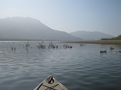
Bow of kayak floating on calm lake with foggy mountains in background
Brush habitats were created and put into Lake Perris to provide fish with habitat to feed and reproduce. The habitats will be completely submersed when the lake is filled to capacity.
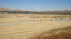
Barren earth with large piles of large rocks distributed throughout
The exposed lakebed gave CDFW fisheries biologists the opportunity to safely construct different kinds of habitat for the fish in Lake Perris.
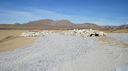
Landscape covered in gravel and piles of large rocks
Rock Reefs and Spawning gravel areas have been created and placed in more than 100 places around Lake Perris that will be utilized once the lake is returned to full capacity.
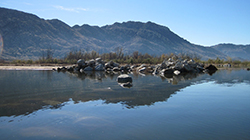
Calm lake facing a pile of large rocks partially submerged with mountains in the background
Rock Reefs constructed along the shore of Lake Perris, most about 1,000 square feet provide cover for juvenile fish and forage species.
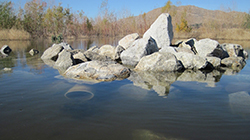
Lake with partially submerged pile of rocks with trees and mountain in the background
135 Pipe Caves were constructed from PVC pipe and will provide spawning habitat for catfish.
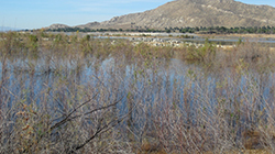
Landscape of lake with overgrown vegetation in foreground, land peninsula with piles of large rocks in midground, and trees and mountains in background
Biologists created about 1,500 brush habitats in hundreds of locations on the banks of Lake Perris and in accessible locations further into the lake.
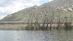
lake with partially submerged vegetation and mountain in the background
Biologists created about 1,500 brush habitats in hundreds of locations on the banks of Lake Perris and in accessible locations further into the lake.

More than a decade ago, Southern California freshwater anglers were disappointed to see a tried-and-true fishing spot dramatically affected by an emergency lake drawdown. Due to seismic concerns with the Perris Dam, California Department of Water Resources (DWR) officials deemed it necessary to reduce the water level at Lake Perris near Riverside by several thousands of acre-feet.

The drawdown exposed about 25 feet of bank around the perimeter of the lake. Since water was not going to be available for years while the dam was assessed and repaired, CDFW embarked upon a fisheries habitat mitigation project (funded by DWR) to create new fish habitat in the remaining water and the now exposed lakebed.

The project had two phases. The first was to immediately create fisheries habitat in the drawn-down portion of the lake in order to maximize use of the remaining water. The second was to build new habitats on the temporarily exposed areas, with the hope of benefitting both sport-fish species and anglers when the lake is eventually refilled. 

After 12 years, both phases are nearly completed.

After the initial water level reduction, teams from CDFW and DWR began working to prevent the immediate collapse of the lake’s fishery. The initial work, which took three years, involved the creation and placement of about 400 fish habitats made of recycled Christmas trees and citrus limbs. The man-made shelters ensured the fish would have places to hide and reproduce.

After the initial triage, CDFW biologists began to place additional habitats into the remaining water of Lake Perris. These habitats, made of thousands of tree trunks, citrus limbs and whole tree stumps would eventually give the lake’s fish an additional 1,500 refuges for safety. 

The citrus limbs were drilled with a ½” hole in the base and multiple limbs were tied together as compactly as possible and attached to a concrete block with polypropylene ropes to weigh them down. They were then placed strategically in different parts of the lake. These citrus habitats should provide cover for the warm water fish for at least 10 - 15 years.

Due to their bulk, increased buoyancy and weight, the single tree stumps were placed individually around the lake and weighted down with concrete blocks to keep them anchored.

Because the lake will be refilled to capacity once dam repairs are complete, it is important that the scientists are able to carefully track each habitat location. They worked in quadrants, placing 20 - 60 bundles into each to create “communities.” The grouped communities increase localized productivity of the warm water fish native to the lake and contribute to maintaining the warm water fisheries while the lake is in its reduced capacity. Each of the quadrant’s corners was marked with GPS, enabling scientists to record and monitor data specific to each location. 

The second phase of the project was the implementation of a Fishery Habitat Plan for the exposed lakebed above the drawn-down area. The implementation of the plan is a requirement of the Lake and Streambed Alteration Agreement between CDFW and DWR.

As with the below-water work that had already been completed, CDFW scientists carefully planned what kinds of habitat to create, what materials to use and where to place them in the open, exposed lakebed in order to provide the best environments for fish when the lake was fully restored. Areas were selected for habitat placement based on accessibility, proximity to existing natural habitat directly affected by the water reduction, avoidance of areas utilized for construction activities, distance from swimming areas and consideration of boating hazards.

Multiple types of habitats were designed and installed in Lake Perris, including:

  • Brush habitats. Similar to the citrus branch habitats already placed in phase one, these brush habitats add to the terrestrial vegetation growth that has thrived in the lakebed since initial triage efforts began in 2006.
  • Pipe caves constructed from 12” diameter PVC pipes. Approximately 4 feet long and capped at one end with concrete, these will provide spawning habitat for catfish that was lost when the lake was drawn down. A total of 135 pipe caves were placed around the rock reefs and terrestrial vegetation and will allow the young catfish to disperse into favored rearing habitat.
  • Rock reefs were created from 226 dump truck loads of material stockpiled by DWR from a nearby rock quarry. These rock piles cover about 110,000 square feet of the lakebed -- about the size of two football fields. Staff created 109 rock reefs, each about 1,000 square feet (about the size of an average home lot). These provide cover for juvenile fish and forage species (such as crayfish) as well as spawning habitat and foraging areas for adult fish. Their placement is designed to allow fish to transition from deeper waters to shallower waters -- and vice-versa -- when the lake returns to normal operating levels.
  • Spawning gravel areas. Thirty of these were created from suitable bottom composition for sunfish, bass, bluegill, etc. to spawn on and around. Almost 200,000 square feet of gravel bed habitat are now in the shallowest areas of the lake, adjacent to rock reefs or terrestrial vegetation that will be covered once the lake refills.

    After years of cooperative work Lake Perris is nearly ready to be refilled and with the thousands of new and improved habitats local anglers will be shouting “fish on” for decades to come. 

CDFW Photos. Top Photo: Citrus tree stumps, weighted down with concrete blocks to keep them anchored were placed individually around Lake Perris to create small habitats called communities.

# # #

Categories: General
CDFW Science Institute logo

Subscribe

Receive Science Institute news by email.