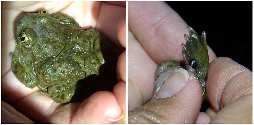
CNDDB logo

Subscribe

Sign up to receive new posts by email.

    Search

    CNDDB News Blog

    All CNDDB Blog Posts

    rss

    Closeup of western thistle.

    Picture a thistle. What do you see? Do you imagine the yellow star-thistle blanketing dry hillsides in the late summer? Or perhaps the bull thistle, with its fat magenta flower heads and spines on every surface?

    We tend to think of thistles as noxious weeds, unwanted invaders, and eyesores. But did you know that California is also home to 19 species of beautiful native thistles, 7 of which are endemic to our state? They may be spiky and sharp, but they are an integral part of many California ecosystems, from ocean dunes to mountain peaks. Thistles also produce a lot of nectar which makes them an important food source for native bumblebees, butterflies, and other pollinators!

    Most of the native plants we would call thistles fall into the genus Cirsium, in the Asteraceae family. Some species of Eryngium also have the common name “coyote thistle” as they have a spiky growth form and similar-looking flowers, but they’re actually in the carrot family (Apiaceae) instead of Asteraceae!

    Suisun thistleOf the 14 Cirsiums that are CNPS-listed as rare species, 4 are federally endangered and 1 is extinct. The one extinct thistle, known as the Lost Thistle (Cirsium praeteriens), was collected near Palo Alto by J. W. Congdon in 1897 and 1901 but it was never seen again.

    CNDDB staff had the opportunity to accompany the CDFW drone team and link opens in new windowNative Plant Program to look for the federally endangered Suisun thistle on CDFW lands in the Delta. There are only a few occurrences of the Suisun thistle, and it grows in salt marshes with thick vegetation that makes it difficult to thoroughly survey on foot. However, drones can fly overhead and thoroughly photograph a site from the air. More and more botanists are turning to drones to survey areas inaccessible to humans, and drone surveys in Hawaii even rediscovered a plant link opens in new windowthought to be extinct. We flew drones over a known population as well as a nearby marsh with suitable habitat, to see if it is possible to use the drones to identify new Suisun thistle populations, or to monitor existing populations. The results of this survey are still being analyzed, but if successful it could be an exciting new tool for plant conservation in California.

    If you’d like to learn more about these misunderstood plants, check out the Xerces Society’s link opens in new windownative thistle guide for more information about the native thistles of North America and their conservation value.

    As always, if you spot one of our rare native thistles, fill out an link opens in new windowOnline Field Survey Form and snap a photo for a chance for your picture to be featured as our Photo of the Month!

    Brown thistle in bloom on the left, and native bumblebee pollinating a Brewer's swamp thistle on the right

    Photo caption: Top: Western thistle (Cirsium occidentale) flower head; Middle right: The federally endangered Suisun thistle (Cirsium hydrophilum var. hydrophilum) grows in Delta salt marshes; Bottom left: Brownie thistle (Cirsium quercetorum) in bloom; Bottom right: Native bumblebee pollinating a Brewer’s swamp thistle (Cirsium douglasii var. breweri
    Photo credit: Top: Kristi Lazar; Middle right: Rachel Powell; Bottom left: Kristi Lazar; Bottom right: Katie Ferguson

    Categories:   Education and Awareness, Taxon of the week

    History Hunters banner

    In addition to keeping track of current populations of rare and sensitive species, the CNDDB records historical species locations. Historical records provide important information on which species might occur in an area, and how species range and abundance may have changed through time. There is a wealth of information available in museum collections and field notes, but it can be a challenge to accurately map historical locations when place names, highway routes, and local landmarks have changed so much in the ~150 years of specimen records we have for California! This series will focus on some of the challenges we encounter and interesting history we uncover while mapping historical rare species data.

    Submerged, but not forgotten.
    Inundated, not extirpated.
    Some we feared drowned
    Hide and wait to be found.
         - Anonymous

    There are over 1300 reservoirs in the state of California, and nearly every major river has been dammed at least once. Many old collections reference towns, bridges, and roads that were abandoned or moved due to reservoir construction. The towns of Mormon Bar, Copper City, and Monticello appear on old topographic maps, but are now buried under the waters of Folsom Lake, Shasta Lake, and Lake Berryessa respectively. It can be difficult to pinpoint exactly where a specimen was collected if it references a landmark that’s now underwater! However, with the 2011-2017 drought the water level was so low in many reservoirs that some of these features link opens in new windowbecame visible again above the surface of the water. For example, the link opens in new windowBartlett Springs Bridge was abandoned in place when Indian Springs Reservoir was built in 1975, but it was rediscovered in 2015 by some intrepid bridge hunters who are now advocating for it to be preserved and restored.

    Map of Monticello before and after Lake Berryessa was formed.
    The town of Monticello (left) was flooded in 1957 when Lake Berryessa (right) was formed.

    Of course, the species represented in historical collections may not still exist at that site if it is now underneath a reservoir! However, this information is still useful to record in case there is still a possibility for that species to occur in the area. It may be that the species in question is able to disperse and reestablish itself in suitable habitat nearby, or that only a portion of the population was wiped out.

    In the case of the Bartlett Springs Bridge, foothill yellow-legged frog was collected there in 1964, 11 years before the reservoir was built. That site may be flooded now, but foothill yellow-legged frogs have been observed more recently in the vicinity of the Indian Valley Reservoir and on the North Fork Cache Creek, so it is possible that they still occur near the Bartlett Springs Bridge as well. The Indian Valley brodiaea is another species with known populations nearby and at least one historical population where the reservoir is now. Both of these species still have the potential to occur in the area, even though the original collection sites are underwater.

    In these cases, surveying suitable habitat in the surrounding area may turn up a population that hasn’t been seen in 50+ years! Even if we are reasonably confident that the population was extirpated, adding that information to the database provides decision makers with better information about the threats to the species as a whole, which they can use to prioritize future conservation efforts.

    Categories:   Education and Awareness

    The hot summer days have not stopped people from going out into the field and exploring the great outdoors. Here are a couple of great Online Field Survey Form photos that were submitted to us in July:

    Pallid bat clinging to a tree

    Antrozous pallidus – pallid bat

    Submitted by Veronica Wunderlich

    Veronica found this pallid bat in a sticky situation – clinging to branches in a pond, unable to get out. She helped relocate it to a safe and dry spot. The pallid bat is an insectivore and typically catches insects found on the ground. CNDDB currently has 420 occurrences in 49 counties across California for this Species of Special Concern. Thank you, Veronica for this submission and the cool story behind the photo!

    Humboldt Bay owl's-clover closeup

    Castilleja ambigua var. humboldtiensis – Humboldt Bay owl’s-clover

    Submitted by Crystal Welch, Botany Technician with BLM office in Arcata, CA

    Crystal, a Humboldt State University grad, professes her good fortune in being able to explore the diverse botanical communities that Humboldt County has to offer, and attributes her love of the natural world to the experiences she has had in Humboldt. A word straight from Crystal, “I love every minute of being outside and contributing to the greater scientific community!”

    This amazing little annual was found in a salt marsh in Humboldt County. It is endemic to California and is commonly found in coastal salt marshes and swamps along the northern coast. Castilleja ambigua var. humboldtiensis more commonly goes by the name Humboldt Bay owl’s-clover. It is listed as a 1B.2 (rare throughout its range) in the California Rare Plant Ranking system and you can see these amazing little flowers from April through August, perfect for those summer hikes! Thank you, Crystal, for all the hard work you do and the love you hold for our beautiful world.

    Do you have some great photos of rare plants or wildlife detections? Submit them along with your findings through our link opens in new windowOnline Field Survey Form and see if your photos get showcased!

    Categories:   Contributor Spotlight

    Biogeographic Data Branch
    Physical Address: 1700 9th Street, 4th Floor, Sacramento, CA 95811
    Mailing Address: P.O. Box 944209, Sacramento, CA 94244-2090
    (916) 322-2493 | BDB@wildlife.ca.gov