What is SCATalogue?
SCATalogue is an iOS app for the collection of Shoreline Cleanup Assessment Technique (SCAT) data. (SCAT) is a systematic method for surveying an affected shoreline after an oil spill. SCAT data is used to map and characterize the extent of shoreline oiling and to document the effectiveness of response measures. During spill response, shoreline assessments generate a large amount of data. Using traditional approaches, managing the SCAT data and associated paperwork, and displaying the results in meaningful maps and tables is time consuming. Demand for this critical information is high, making efficient data processing and dissemination crucial. SCATalogue’s digitally captured data can be processed quickly and accurately by GIS staff in the incident command post, and clearly displayed for use by command staff and other responders. SCATalogue also allows for automated georeferencing of data (i.e., track log, SCAT segments, oiling zones, pits/trenches, photos, etc., with associated lat./long. coordinates).
Data captured using the SCATalogue App aids in the processing, integrating, and displaying of information more accurately than traditionally paper-bound means, and eases data management. The California Department of Fish and Wildlife, Office of Spill Prevention and Response (OSPR) utilizes SCATalogue to maximize the collection and processing efficiency of SCAT data during response to pollution events. SCATalogue is now available to everyone for their use.
This web page presents SCATalogue's status, features, design considerations, inherent technology limitations and their mitigations, and envisioned future revisions. Presented herein, is also a diagram of SCATalogue's place in the overall SCAT workflow including the backend database work, integration with the Common Operational Picture (COP), and other applications and technologies used to facilitate data integration.
Data captured using the SCATalogue app aids in the processing, integrating and displaying of information more accurately than traditionally paper-bound means and eases data management. CDFW-OSPR can respond to pollution events with increased efficiency and resource use with SCATalogue.
SCATalogue History
Since its inception in 1991, OSPR has been collecting SCAT data to map and characterize the extent of shoreline oiling and to document the effectiveness of the cleanup actions. OSPR collects SCAT data in accordance with the SCAT forms developed by the National Oceanic and Atmospheric Administration (NOAA). Processing SCAT paper forms was a time consuming process that required manual transcription of data, and created the potential for transcription errors. Beginning in 2009, OSPR began using an electronic data collection application. However, when the Refugio Spill occurred on May 19th 2015; because of ongoing issues with the original commercially available SCAT program used by OSPR, and the associated data processing, the decision was made to revert back to using paper SCAT forms.
Following Refugio, OSPR recognized the value of digital SCAT data collection and initiated development of a new SCAT data collection program. Other governmental agencies and private companies have developed electronic SCAT data collection efforts with mixed results. OSPR's extensive experience with SCAT paper forms and the associated back-end GIS processing, and its recent in-house development and completion of an iOS App for wildlife recovery operations, culminated in the decision to create its own iOS SCAT app called SCATalogue.
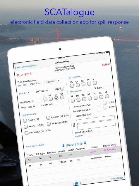
How SCATalogue is used?
The iOS/iPad SCATalogue app replaces the use of the NOAA Shoreline Oiling Summary paper forms in the field, and eliminates the need for subsequent transposition of that data into a digital format. SCAT teams collect shoreline assessment data in the field using the same form content, terms, and measurements as with the paper-based NOAA SCAT forms, but do so with the digital forms in the app, with the auto-collected information (e.g., GPS location data). The app does not require an internet connection or cell service for use in the field; it was designed for offline usage. Once a survey is completed, the data can be transferred via email, flash drive, iTunes, or via local WiFi as soon as available.
GIS specialists, using custom scripts/tools (available below under “ArcGIS Tools”) then process the incoming data (geoJSON) into a geodatabase. After a QA/QC review, the survey data is pushed into a central SQL geodatabase, which contains all the data for an incident/spill event. Maps, Shoreline Oiling Summary forms (PDFs), and various reports are then created for use by the Unified Command.
On what mobile devices can SCATalogue be used?
The SCATalogue app is available for iOS devices, specifically iPads. The iOS platform was chosen because CDFW policy currently does not allow the use of the Android OS. Additionally, OSPR had previously developed an iOS app for Wildlife Recovery using iOS, and this experience was valuable for development of SCATalogue on iOS as well.
Support
The Geographic Information Systems (GIS) Unit is a function of OSPR’s Spill Response Technology and Support group within the OSPR Scientific Branch. The GIS Unit provides the technology infrastructure and support services needed by staff to carry out the OSPR’s mission. The GIS Unit continuously strives to make GIS easier to use, and develops applications to support decision-making within OSPR and as part of a Unified Command during spill response.
For more information and support; please email, OSPRGIS@wildlife.ca.gov
Documentation