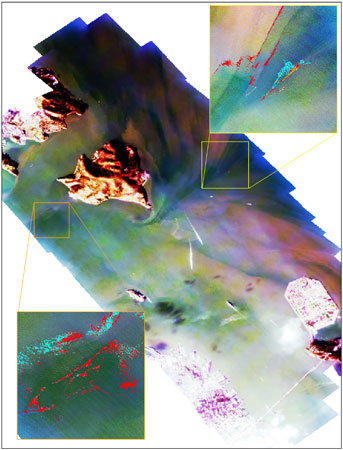
Multispectral Image of the Cosco Busan Oil Spill in
San Francisco Bay,
November 9, 2007 (Ocean Imaging, Inc.).
The Resource Inventory - Geographic Information System (GIS) Unit is a function within the Response Support located in the Scientific Branch. The GIS Unit provides the technology infrastructure and support services needed by staff to carry out the OSPR’s mission. The GIS Unit continuously strives to make GIS easier to use and develops applications to support decision-making within the OSPR.
Priorities
The primary GIS Unit responsibility is supporting oil spill response on-site in an Incident Command Post (ICP) or to provide support remotely to the field from the Sacramento headquarters.
In Sacramento the GIS Units highest priority is to support the Sacramento Department Operations Center (DOC). Response efforts include the incident investigation by
OSPR’s Marine Safety Branch, Law Enforcement division, Legal Branch, and the post natural resource damage assessment team (NRDA). When not occupied by response related work the next highest priority is supporting planning and preparedness efforts.
Area Contingency Plans (ACPs)
The OSPR GIS Unit works closely with the OSPR ACP Coordinator and Scientific Field Response Team members to create maintain and update all GIS layers and map products required in the ACPs.
Response Readiness
The OSPR GIS Unit is prepared to immediately support the DOC and/or be fully functional in the ICP within 24-36 hours after initial notification.
Drills and Exercises
The OSPR GIS Unit is committed to supporting drills and exercises as requested. For major drills such as Preparedness for Response Exercise Program (PREP), Spill of National Significance (SONS), or select Full Scale Exercise (FSE) the GIS Unit will provide on-scene support. The GIS Unit can provide support remotely from Sacramento for smaller exercises.
GIS Data
GIS shapefiles and KMZ files available for download: