Regional Contingency Plans
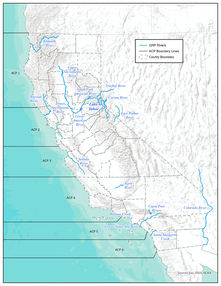 ACP-GRP boundaries map - Click for larger image
Regional Response Team IX is responsible for ensuring:
- that state and federal resources are available when needed for emergency response to toxic spills within the states of Arizona, California and Nevada, and the 146 tribal nations located in those states; and
- that the multi-agency relationships and coordination systems exist to support these emergency response efforts.
The Regional Response Team IX Contingency Plan has been published to best support the deployment of those response resources:
California State Oil Spill Contingency Plan
The California State Oil Spill Contingency Plan (SOSCP) (PDF) ) is designed to ensure the best achievable protection of the state's waters from oil spills, consistent with the requirements of section 8574.7 of the California Government Code and the Lempert-Keene-Seastrand Oil Spill Prevention and Response Act. The 2026 SOSCP outlines the coordinated framework to prevent, prepare for, and safely respond to oil spills, while prioritizing the protection of environmentally, culturally, and ecologically sensitive areas. All state and local agencies must carry out spill response activities consistent with this Plan and other applicable federal, state, or local spill response plans.
Area Contingency Plans (ACP) for Marine Waters
The statutes (OPA 90 and SB 2040) enacted in consequence of the catastrophic oil spills of 1989, required contingency planning by both State and Federal Governments. The U. S. Coast Guard (USCG) and CDFW Office of Spill Prevention and Response (OSPR) agreed to joint preparation of six contingency plans through co-chairing the three Port Area Committees for Contingency Planning: USCG Port Areas for San Francisco, Los Angeles / Long Beach, and San Diego. The Environmental Sensitive Site Protection regulations (PDF) set forth planning requirements for environmental sensitive site protection for vessels and facilities that pose a spill risk to California's marine waters.
The Area Committee planning process is a proactive effort to deal with potential oil releases. It is open to all interested parties and has involved representatives from over 50 agencies, including federal, state, local, industry and environmental participants. The three Port ACPs provide guidance for the first 24 hours of response, and each of the six coastal planning areas have provided detailed evaluation and recommendations for protection of regional shoreline resources. ACPs are updated on a regular schedule (currently every five years), and the respective Area Committees meet regularly to discuss lessons learned from spills, drills and exercises to inform updates to the ACPs. Between revision cycles, annual updates to the ACPs may be posted. The USCG released the Coastal ACP Handbook in 2025 which provides guidance for Area Committee planning and ACP standardization across the nation.
- Sector San Francisco Area Contingency Plans
- ACP 1 includes Del Norte, Humboldt and Mendocino counties
- ACP 2 includes Sonoma, Marin, Napa, Solano, Contra Costa, Alameda, Santa Clara, San Mateo, San Francisco, Yolo, San Joaquin, and Sacramento counties
- ACP 3 includes Santa Cruz and Monterey counties
- Sector L.A./Long Beach Area Contingency Plans
- ACP 4 includes San Luis Obispo, Santa Barbara, and Ventura counties and northern Channel Islands
- ACP 5 includes Los Angeles and Orange counties and southern Channel Islands
- Sector San Diego Area Contingency Plan
- ACP 6 includes San Diego County
Geographic Response Plans (GRP) for Inland Waters of the State
Geographic Response Plans (GRPs) are being updated and developed by OSPR in conjunction with other federal, state, and local government, industry and other partners for priority inland waters of the state with higher risk of an oil spill. GRPs will be driven by access to sites along river systems and lakes where response activities are feasible. The intention is that GRPs will be vetted through the regional Local Emergency Planning Committees (LEPCs) comprised of industry representatives, federal, State, and local government agencies, public health agencies, tribal representatives and other stakeholders, and may utilize local subcommittees to the LEPCs to provide further input and review of the GRPs.
- Ballona Creek Geographic Response Plan (PDF)
(Los Angeles County) - Updated Dec. 2024
- Cajon Pass Geographic Response Plan (PDF)
(San Bernardino County)
- Kern River Geographic Response Plan (PDF)
(Kern County)
- Klamath River Geographic Response Plan (PDF)
(Siskiyou, Humboldt, Del Norte Counties)
- Lower American River Geographic Response Plan (PDF)
(Sacramento County)
- Lower Sacramento River Geographic Response Plan (PDF)
(Shasta, Tehama, Glenn, Butte, Sutter, Colusa, Yolo and Sacramento Counties)
- Lower Santa Ana River Geographic Response Plan (PDF)
(Riverside and Orange Counties)
- North Fork American River Geographic Response Plan (PDF)
(Placer, El Dorado and Sacramento Counties)
- Russian River Geographic Response Plan (PDF)
(Mendocino and Sonoma Counties)
- Salinas River Geographic Response Plan (PDF)
(Monterey County)
- Santa Margarita River Geographic Response Plan (PDF)
(Riverside and San Diego Counties)
- Upper Sacramento River Geographic Response Plan (PDF)
(Siskiyou and Shasta Counties)
- Geographic Response Plan Companion Manual (PDF)
- California, Nevada, Arizona Interstate Geographic Response Plans
- Public Participation - LEPC Meetings