Volcanic Creek, Tulare County
Species / Location
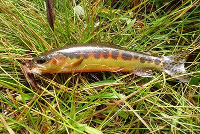 Figure 1. California Golden Trout. (CDFW photo)
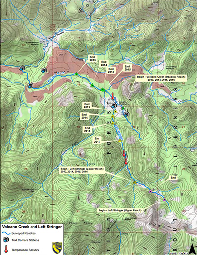 Figure 2. Minimum observed stream lengths for Volcanic Creek and Left Stringer, digital trail camera, and temperature sensor locations.
 Figure 3. Volcano Meadow, Tulare County, CA. (CDFW photo)
California Golden Trout (Oncorhynchus mykiss aguabonita), a subspecies of rainbow trout, are native to South Fork Kern and Golden Trout Creek watersheds located on the western slope of the Sierra Nevada (Figure 1). Most populations of Golden Trout have interbred with other rainbow trout, diluting their genetic integrity. Volcanic Creek supports one of the few remaining genetically pure populations of Golden Trout because it is remote and only intermittently connected to Golden Trout Creek.
Need for Drought Stressor Monitoring:
Volcanic Creek’s dependence on spring water and lack of connectivity to Golden Trout Creek pose risks to the sustainability of the creek’s small Golden Trout population. Extended drought conditions make these challenges even greater by further reducing water supply and available habitat. 2013 and 2014 were two of the driest years on record in California (CDWR, 2014), and the state responded by declaring a state of emergency and implementing water conservation and monitoring efforts. Drought conditions persisted through 2015 and into 2016, continuing to stress vulnerable species and populations.
Stressor Monitoring Efforts
The California Department of Fish and Wildlife (CDFW) responded to potential drought-related effects on this population by initiating monitoring efforts in Volcanic Creek and its tributary, Left Stringer Volcanic Creek. CDFW scientists performed visual encounter surveys at three locations within the watershed to determine the status of the California Golden Trout population (Figures 2 and 3). CDFW documented the extent of wet and dry stream reaches and measured pool habitat. Temperature sensors were placed in Volcanic Creek, Left Stringer, and other nearby Golden Trout waters (Salt Lick Meadow, Groundhog Meadow, and Golden Trout Creek). Digital trail cameras documented the drying of the streams, the extent of stream connectivity with Golden Trout Creek, and visitor use information (Figure 2).
Findings
Habitat Monitoring
Habitat conditions in 2016 were either similar or improved over those in 2015, but were generally worse than those observed in 2013 and 2014. For example, in June 2016, a survey of Volcanic Creek (Meadow Reach) found that wetted stream habitat was 34% longer than observed in June 2015 but 10% shorter than observed in June 2014 and 38% shorter than in September 2013 (Table 1). The length of wetted habitat in August 2016 stabilized at roughly the same end point as in August 2015 (Table 1). Over the summer of 2016, Lower Left Stringer receded to approximately 2.4 km in August, similar in length to the beginning of the summer in 2015 (Table 1). By September 2016, the reach extended an additional 0.3 km for a wetted length of 2.7 km, similar to that seen in 2014. In addition, the number of pool habitats deeper than 300 mm increased from 12 pools in 2015 to 29 pools in 2016, a 142% increase. Upper Left Stringer Reach, which was only monitored in 2015 and 2016, maintained a wetted length of .56 km over the entirety of the monitoring period.
Table 1. The number of California Golden Trout and quantity of stream habitat determined at Volcano and Left Stringer creeks during the summers of 2013 through 2016.
| |
Volcano Creek Meadow |
Left Stringer Volcano Creek (Lower Reach) |
Left Stringer Volcano Creek (Upper Reach) |
| Survey Date |
Wetted Length (km) |
Golden Trout Counts |
Wetted Length (km) |
Golden Trout |
Wetted Length (km) |
Golden Trout Counts |
| September 10, 2013 |
2.09 |
Not Surveyed |
Not Surveyed |
Not Surveyed |
Not Surveyed |
Not Surveyed |
| June 11, 2014 |
1.45 |
Not Surveyed |
Not Surveyed |
Not Surveyed |
Not Surveyed |
Not Surveyed |
| July 30, 2014 |
1.45 –0.026 |
Not Surveyed |
2.7 |
466 |
Not Surveyed |
Not Surveyed |
| September 23, 2014 |
1.45 –0.026 |
152 |
2.7 |
307 |
Not Surveyed |
Not Surveyed |
| June 17-18, 2015 |
0.97 |
108 |
2.4 |
214 |
0.56 |
63 |
| July 7-8, 2015 |
0.97 + 0.015 |
86 |
2.4 + 0.053 |
129 |
0.56 |
71 |
| July 28-29, 2015 |
0.97 – 0.015 |
72 |
2.4 – 0.487 |
158 |
0.56 |
60 |
| August 17-19, 2015 |
0.97 – 0.023 |
52 |
2.4 – 0.71 |
174 |
0.56 |
38 |
| September 1-3, 2015 |
0.97 – 0.008 |
61 |
2.4 – 0.629 |
156 |
0.56 |
55 |
| September 15-16, 2015 |
0.97 + 0.017 |
53 |
2.4 – 0.271 |
150 |
Not Surveyed |
Not Surveyed |
| June 17-18, 2016 |
1.3 |
48 |
3.4 |
53 |
0.56 |
61 |
| July 27-28, 2016 |
0.97 |
26 |
2.9 |
79 |
0.56 |
28 |
| August 18-19, 2016 |
0.97 |
18 |
2.4 |
134 |
0.56 |
47 |
| September 20, 2016 |
0.97 |
Not Surveyed |
2.7 |
Not Surveyed |
0.56 |
44 |
Population Monitoring
To date, 2016 had the lowest fish counts for all reaches. From July 2014 to June 2016, the number of Golden Trout documented declined by 81% in Volcanic Creek and 71% in Lower Left Stringer. Both sites saw declines in counts over the winters of 2014-2015 and 2015- 2016. This is especially true of Lower Left Stringer and is likely due to formation of anchor ice, which forms in stream bottom habitat and prevents fish from escaping freezing conditions. In addition, both Volcanic Creek and Lower Left Stringer saw summer mortality in 2015 due to stranding by stream drying. This was not observed in 2016. The Upper Left Stringer was the most stable reach, with a similar number of Golden Trout observed from June 2015 to June 2016.
Due to low fish population counts, threat of winter kill from anchor ice, and unknown impacts to wetted reaches, CDFW rescued 52 Golden Trout from the three reaches and transported them to the American River Hatchery. They will be kept at the hatchery until conditions improve and they can be safely returned back to Volcanic Creek and Left Stringer. The need for this rescue would not have been understood without drought stressor monitoring.
Water Temperature Monitoring
Both Left Stringer and Volcanic Creek experienced near-freezing temperatures in the winter of 2015, which likely facilitated the formation of anchor ice along the bottom of shallow portions of the stream (Figures 4 and 5). Winter mortality resulting from anchor ice may explain the sharp decrease in observed Golden Trout from September 2015 to June 2016. An additional temperature sensor was placed in representative deep pool habitat of Left Stringer during the summer of 2016 to provide a greater understanding of pool habitat conditions in the future.
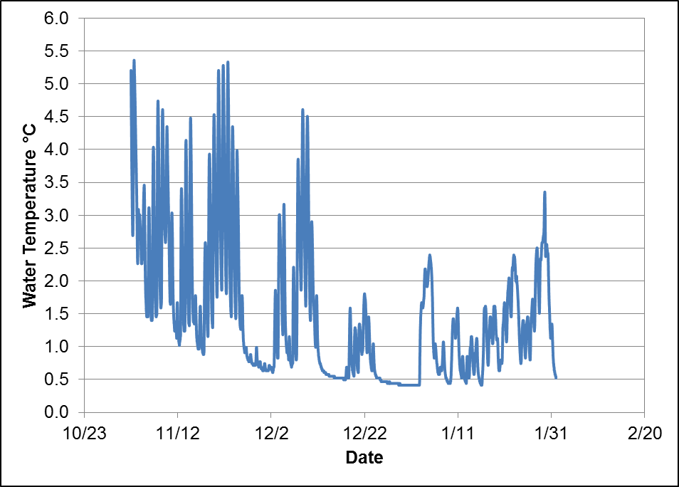 Figure 4. Water temperature in Volcanic Creek (Meadow Reach) from November 2, 2015 through January 31, 2016.
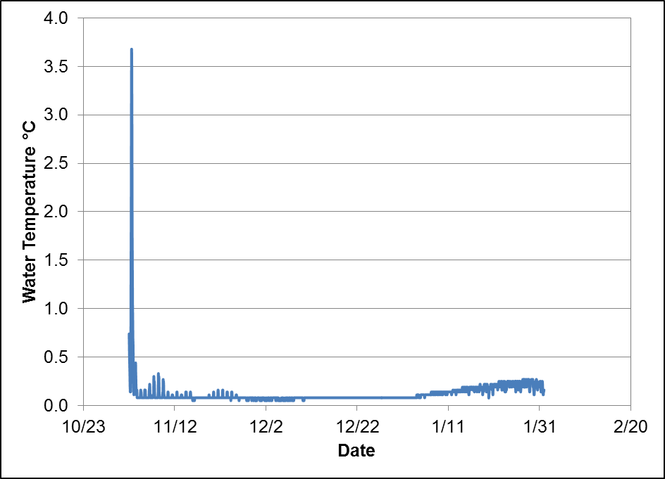 Figure 5. Water temperature in Left Stringer from November 2, 2015 through January 31, 2016. This temperature logger was placed in a shallow pool, and may not represent the conditions of deeper pool habitats.
Future Efforts
Reintroduction of rescued California Golden Trout is CDFW’s highest priority. Monitoring data provide critical information, allowing for informed management decisions on reintroduction of rescued California Golden Trout. Improved stream flow conditions should increase pool habitat and lessen the impacts of anchor ice, aiding in Golden Trout reintroduction success and population recovery. Continued population, habitat, and stream temperature monitoring is necessary to assess how California Golden Trout populations respond to continued drought or improved conditions.
References
CDFW