(Volcanic Creek, Tulare County)
Species / Location
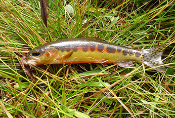 Figure 1. Volcanic Creek strain of California golden trout. (CDFW photo)
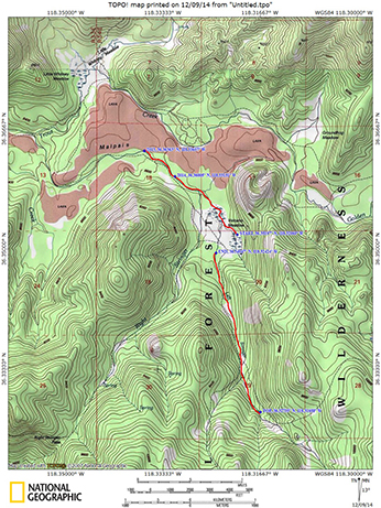 Figure 2. Volcanic Creek and Left Stringer Volcanic Creek, Golden Trout Wilderness (Tulare County).
The Volcanic Creek strain of California golden trout (CGT, Figure 1) is considered to be the most genetically pure population within the native range of CGT. The genetic integrity of the Volcanic Creek strain (Oncohynchus mykiss aguabonita) of CGT is a result of its remote location and intermittent connection with Golden Trout Creek. It is not known how often the connection is established with Golden Trout Creek.
Need for Drought Stressor Monitoring
Volcanic Creek’s dependence on spring sources for water, small CGT population size, and lack of connectivity to Golden Trout Creek all pose risks to the sustainability of the population. Extended drought conditions make the challenges even greater for the persistence of CGT. Water years 2013 and 2014 were two of the driest years on record in California (CDWR, 2014), and California responded by declaring a state of emergency and implementing water conservation and monitoring efforts.
Stressor Monitoring Efforts
The California Department of Fish and Wildlife (CDFW) responded to potential drought-related effects to this population by initiating monitoring efforts in Volcanic Creek and Left Stringer Volcanic Creek (Figure 2). Visual encounter surveys were performed to document CGT populations. The extent of wet and dry stream reaches were documented and the quantity of flow and pool habitat were measured. Temperature measuring devices were placed in Volcanic Creek, Left Stringer Volcanic Creek, and other nearby CGT waters (Salt Lick Meadow, Bullfrog Meadow and Golden Trout Creek). Digital trail cameras were installed to document the drying of the streams, the extent of hydrological connectivity with Golden Trout Creek, as well as visitor use information. The information gained provides important information about the species and informs resource management decisions.
Findings
On June 11, 2014, CDFW made an initial trip to Volcanic Creek to document beginning and end points of stream flow (Figures 3 and 4). At that time, CDFW installed digital trail cameras to document flow, connectivity with Golden Trout Creek, and visitor use. CDFW found that the length of wetted streambed was 0.9 miles, approximately 31% less than it was at the same time of year in 2013.
On July 30, 2014, a second trip was made to Volcanic Creek to perform visual encounter surveys for CGT. Wetted length of Volcanic Creek remained about the same (0.9 miles) with the end point receding approximately 85 feet. Two hundred, fifty-five trout were found within the survey reach.
A visual encounter survey was conducted on Left Stringer Volcanic Creek on July 31, 2014. Left Stringer Volcanic Creek went subsurface before entering Volcano Meadow and did not connect with Volcanic Creek. CDFW believes this is the normal condition and that a connection is established in most years during the spring runoff. The survey reach was approximately 1.5 miles in length. Four hundred, sixty-six trout were observed within the reach.
Fish habitat extended approximately 320 feet above the top end of the survey reach. At this point, the gradient became steeper and the channel braided, forming a potential fish passage barrier, although stream flow continued upstream. CDFW recommends future surveys of this upper stream reach to confirm that no trout are present.
A third and final trip was made to Volcanic Creek and Left Stringer Volcanic Creek on September 23, 2014. Wetted lengths of both Volcanic Creek and Left Stringer Volcanic were approximately the same. Visual encounter surveys for CGT produced similar results to those from the July 2014 survey. At the conclusion of the 2014 field season, spring sources and input from summer thunder storms have sustained the CGT populations through the prolonged drought.
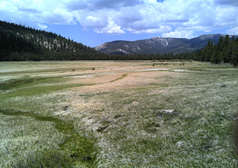 Figure 3. Volcano Meadow on June 11, 2014. (CDFW photo)
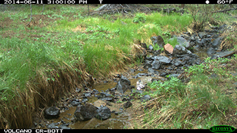 Figure 4. Photo from trail camera documenting flow near endpoint of Volcanic Creek in June 2014. (CDFW photo)
Future Efforts
CDFW recommends continuing existing monitoring of Volcanic Creek and Left Stringer Volcanic Creek CGT populations if drought conditions persist. Loss of habitat was documented and the study should continue until the population fully recover in the affected reaches. Additional trail cameras should be placed to determine timing and duration of connectivity of Left Stringer Volcanic Creek and Volcanic Creek.
References
CDFW
Riverside-Corona Resource Conservation District