Volcanic Creek, Tulare County
Species / Location
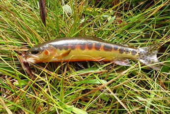 Figure 1. California Golden trout, CDFW file photo, September 12, 2013.
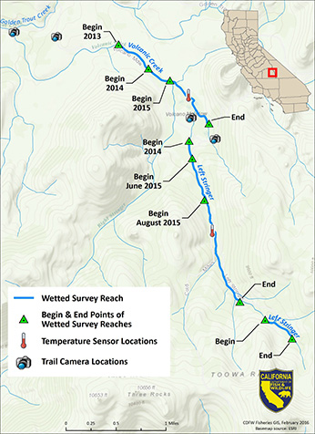 Figure 2. Map of Volcanic Creek and Left Stringer Volcanic Creek on the western slope if the Sierra Nevada noting the locations of trail cameras, temperature loggers, and visual encounter surveys.
 Figure 3. Volcano Meadow (Tulare County), CDFW file photo, September 15, 2015.
California golden trout (Oncorhynchus mykiss aguabonita), a subspecies of rainbow trout, is native to South Fork Kern and Golden Trout Creek watersheds located on the western slope of the Sierra Nevada (Figures 1 & 2). The Volcanic Creek strain of California golden trout is considered to be one of the few genetically pure populations remaining within the native range of this subspecies.
The genetic integrity of the Volcanic Creek strain is a result of its remote location and intermittent connection with Golden Trout Creek which reduces the potential for interbreeding with less pure strains of California golden trout.
Need for Drought Stressor Monitoring
Volcanic Creek’s dependence on spring sources for water, small population size, and lack of connectivity to Golden Trout Creek all pose risks to the sustainability of the population. Extended drought conditions make the challenges even greater for the persistence of California golden trout. Water years 2013 and 2014 were two of the driest years on record in California (CDWR, 2014), and California responded by declaring a state of emergency and implementing water conservation and monitoring efforts. Meteorological data shows that drought conditions persisted through 2015.
Stressor Monitoring Efforts
The California Department of Fish and Wildlife (CDFW) responded to potential drought-related effects on this population by initiating monitoring efforts in Volcanic Creek and Left Stringer Volcanic Creek (Figure 3). Visual encounter surveys were performed at various locations within the watershed to determine status of California golden trout populations (Figure 2). The extent of wet and dry stream reaches were documented and pool habitat was measured. Temperature sensors were placed in Volcanic Creek, Left Stringer Volcanic Creek, and other nearby golden trout waters (Salt Lick Meadow, Groundhog Meadow, and Golden Trout Creek). Digital trail cameras were installed to document the drying of the streams, the extent of hydrological connectivity with Golden Trout Creek, as well as visitor use information. The information gained provides important information about the species and informs resource management decisions.
Findings
Fish Population and Habitat Monitoring
On June 17, 2015, a survey of Volcanic Creek (meadow reach) found one kilometer of continuous stream habitat. The wetted stream habitat was 0.4 kilometers shorter (29% reduction) than the 1.4 kilometers observed in June 2014 and 52% reduction of wetted reach from the 2.1 kilometers observed in 2013 (Table 1). Visual encounter surveys documented a total of 108 California golden trout, down 58% from the 255 California golden trout observed in July 2014 (Table 1).
Left Stringer Volcanic Creek was also surveyed on June 17-18, 2015. The wetted extent of this creek was approximately 0.3 kilometers shorter than observed in 2014. A visual encounter survey conducted on June 17, 2015 counted a total of 246 California golden trout (2.5 km reach), slightly more than half of the 466 California golden trout observed in July 2014. This survey reach ended at a high gradient, highly-braided reach characterized by large cobble/boulder and dense willow trees, where it was difficult to gain access to conduct surveys. On June 18, 2015, a crew hiked above this high gradient section to assess the upstream habitat. An additional 63 golden trout were observed in 0.6 kilometers of stream habitat. This additional habitat contributed to a total of 3.5 kilometers of continuous habitat in Left Stringer Volcanic Creek in June 2015.
Additional surveys were performed on July 7-8, July 28-29, August 17-19, September 1-3 and on September 15-16, 2015 (Table 1). During this period, Volcanic Creek (Meadow Reach) remained relatively stable with minor (less than 23 meters) fluctuations in the extent of the wetted reach. Counts of golden trout declined to approximately 60 golden trout in August through September. Some mortality was observed at the bottom of the reach and is most likely associated with stranding of fish with the ebb and flow of the creek. The ability to make visual observations of fish degraded as the summer progressed due to increased vegetative growth along and within the stream channel, resulting in fewer fish observed.
Left Stringer Volcanic Creek saw a marked reduction in wetted reach in late July through August. During this period, this creek receded almost three quarters of a kilometer (710 meters). Some mortality was observed and stranding was witnessed with one isolated pool harboring 15+ fish. The upper reach of the creek remained stable for both flow and California golden trout populations throughout the summer season.
Surveys performed in early September documented that both the meadow stream and Left Stringer Volcanic Creek had withstood the critical summer dry season and that the wetted reaches of both streams began to extend, providing more habitat.
The isolated pool and stranded fish in Left Stringer Volcanic Creek persisted until it was reconnected in mid-September. However, at the end of the season, golden trout populations in Volcanic Creek (meadow reach) were about one quarter of that observed in 2014. Populations in the lower reach of Left Stringer Volcanic Creek were approximately one third that observed in 2014.
Table 1. The number of California golden trout and quantity of stream habitat determined at Volcano and Left Stringer Volcanic creeks during the summers of 2013 and 2015.
| Survey Data |
Volcano Creek (Meadow Reach Wetted length (km) |
Volcano Creek
Golden Trout counts |
Left Stringer Volcano Creek (Lower Reach) Wetted Length (km) |
Left Stringer Volcano Creek Golden Trout Counts |
Left Stringer Volcano Creek (Upper Reach) Wetted Length (km) |
Left Stringer Volcano Creek (Upper Reach) Golden Trout Counts |
| Sep 10, 2013 |
2.1 km |
Not Surveyed |
Not Surveyed |
Not Surveyed |
Not Surveyed |
Not Surveyed |
| June 11, 2014 |
1.4 km |
Not Surveyed |
Not Surveyed |
Not Surveyed |
Not Surveyed |
Not Surveyed |
| Jul 30, 2014 |
1.4 km -26 m |
255 |
2.6 km |
466 |
Not Surveyed |
Not Surveyed |
| Sep 23, 2014 |
1.4 km – 26m |
152 |
2.6 km |
307 |
Not Surveyed |
Not Surveyed |
| Jun 17-18, 2015 |
1 km |
108 |
2.5 km |
214 |
0.6 km |
63 |
| July 7-8, 2015 |
1 km + 15 m |
86 |
2.5 km + 53m |
129 |
0.6 km |
71 |
| July 28-29 2015 |
1 km - 15 m |
72 |
2.5 km – 487m |
158 |
0.6km |
60 |
| Aug 17-19, 2015 |
1 km – 23 m |
52 |
2.5 km -710m |
174 |
0.6 km |
38 |
| Sep 1-3, 2015 |
1 km – 8m |
61 |
2.5 km – 629 m |
156 |
0.06 km |
55 |
| Sep 15-16, 2015 |
1 km +17 m |
53 |
2.5 km -271 m |
150 |
Not Surveyed |
Not Surveyed |
Water Temperature Monitoring
Temperature sensor data for Volcanic Creek (meadow reach) show the highest average monthly temperatures (11.5 oC) were recorded in July 2015 (Figure 4). The coldest temperature recorded was 0.1 oC. Late December 2014 to early January 2015 showed a continuous run of 0.1 oC or near 0.1 oC readings, indicating the possible freezing of the stream, a condition known as “anchor ice” (Figure 5). The formation of anchor ice can cause “fish kills” during the winter. Formation of anchor ice may explain the fewer numbers of fish observed in June of 2015 compared to the September 2014 visual surveys.
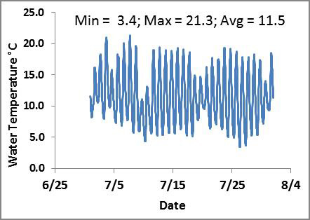 Figure 4. Water temperature in Volcanic Creek (Meadow Reach) during July 2015.
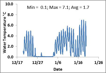 Figure 5. Water temperature in Volcanic Creek (Meadow Reach) from late December 2014 through early January 2015.
Temperature sensor data for Left Stringer Volcanic Creek show a similar pattern as that seen in the meadow reach. However, temperature extremes appear to be moderated in the forested habitat of this Creek, and the average temperature was slightly higher than the average meadow temperature during this period.
Future Efforts
Reduced flows, resulting in diminished wetted habitat place California golden trout populations at greater risk to winter kill due to the formation of anchor ice. Continued population and stream temperature monitoring is recommended to assess California golden trout populations in the advent of continued drought or improved water conditions. Digital trail camera monitoring is ongoing to determine timing and duration of connectivity of Left Stringer Volcanic Creek with Volcanic Creek (meadow reach) and connectivity of Volcanic Creek with Golden Trout Creek.
References
DWR, 2014. Breaking Drought News. WRCC climate region dry years, ranked by inches of precipitation. Access May 06, 2014.
CDFW