Species and Concerns
The Merced River flows from Southern Yosemite National Park 135 miles downstream to the San Joaquin River (SJR) confluence. It is the southern-most SJR tributary containing self-sustaining salmonid populations, including fall-run Chinook salmon (Oncorhynchus tshawytscha), and Central Valley DPS steelhead (Oncorhynchus mykiss irideus) (CNDDB 2023).
When hydrological connectivity is disrupted, it directly impacts the ecosystem for not just salmonid species, but all aquatic organisms by deteriorating the water quality. (Lake P.S, 2003). Riffles dry before pools, stranding fish and aquatic invertebrates. Uneven drying has been found to cause shifts in biological communities to favor pond type organisms over riffle assemblages and may have prolonged effects on community structure even after rewetting (Stanley et al 1997). Dry streams eliminate critical wildlife resources including salmonid freshwater habitat, migration, and spawning (CVRCB 2019). Beyond environmental damage, there is damage to the public trust when the State allows a perennial stream to go dry. Recreation, including fishing, canoeing, and rafting is lost, which can result in negative public impression and consequences (Henry 2022).
Dry perennial stream impacts are a major concern to CDFW staff. Drought monitoring results in 2015, 2016 and 2021 (Atkinson et al. 2018), revealed that parts of the Lower Merced River are likely to disconnect near Hatfield State Park, 2.5 river miles (RM) upstream from the confluence, under severe drought conditions. Because of this, a large focus of SJR basin drought monitoring was allocated to this section of the river in 2022. Based on the nearest flow measuring gauge, there is reason to believe that the portions of the Merced River channel has disconnected outside of the extreme drought period, prior to the 2022 observations.
Methods
To document the status of the Lower Merced River, a series of kayaking and hiking trips were conducted to identify locations where the river channel was dry, disconnected, or blocked by water hyacinth (Eichhornia crassipes). Hiking surveys were conducted from RM 4.5 downstream to Hatfield Park (RM 2.5) in mid-July, after learning the channel had become completely disconnected at RM 2.5 (Figures 1 and 2). Geotagged photos using the Timestamp iOS application were taken to document channel blockages, disconnections, or isolated pools (Figure 3). Monthly surveys were conducted for the same reach of the river to monitor the extent and severity of these drought conditions. In addition, a weekly photographic timeline was documented at Hatfield State Park, noting the recorded flow measurements that correlated with the time each photo was taken was from the Merced River near Stevinson (MST) CDEC gauge.
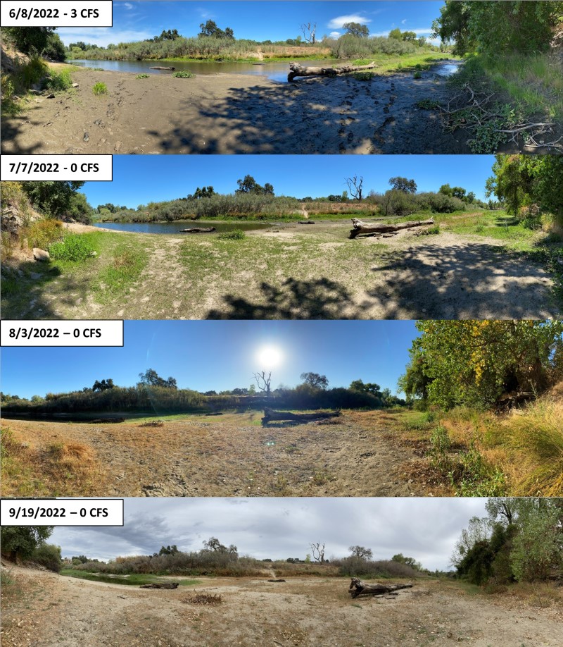 Figure 1. Photographic timeline of the river habitat conditions upstream of Hatfield Park bridge (RM 2.5) The river channel started narrowing in early June and became completely disconnected at this location by July 7, 2022. The riverbed remained dry until early October 2022.
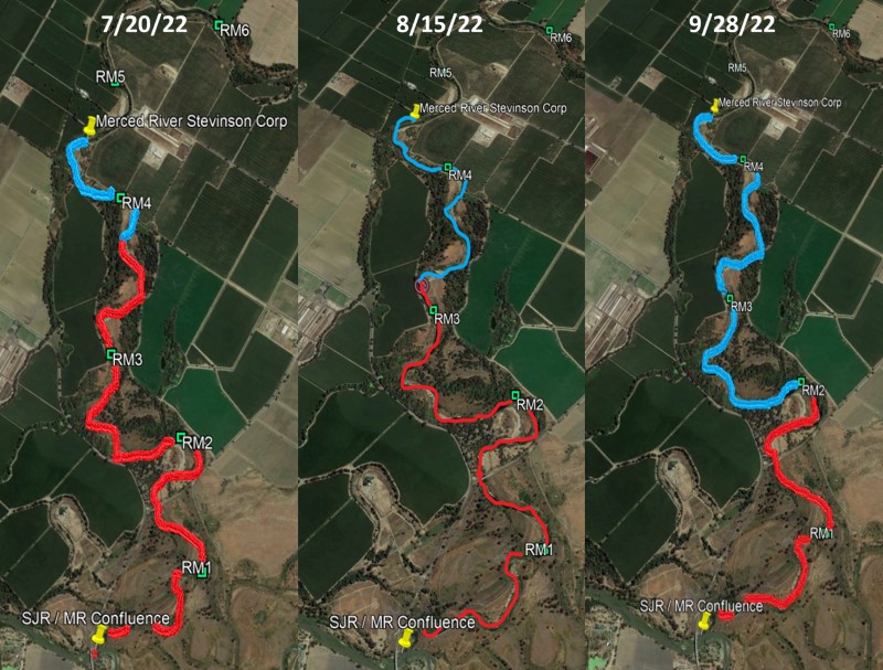 Figure 2. Portions of the Lower Merced River between RM 5 and the confluence were severely impacted by the drought. Blue traces indicate that the channel is still connected/wetted. Red traces indicate disconnected/dry portions, or intermittent isolated pools.
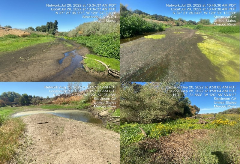 Figure 3. Photos revealing portions of the Merced River severely impacted by the drought in 2022. The river below RM 4 disconnected with isolated pools from July 20, 2022 to September 28, 2022. The bottom-right image shows the main channel completely blocked by hyacinth and vegetation due to the lack of streamflow.
Average daily stream flow and water temperatures on the Merced River for 2021-2022 were monitored using the uppermost and lowermost CDEC gauges for each parameter. Both upper river streamflow and water temperature was collected using CDEC Merced River Below Crocker Huffman Dam (MBH), and water temperatures were recorded near the Merced River Hatchery (MRH, RM 52). Streamflow for the lower reach was recorded near Stevinson (RM 5), and temperatures for the lower reach were recorded near Cressey bridge at (RM 29).
Results
On July 7, 2022 CDFW drought monitoring staff found the Merced River to be completely disconnected from the San Joaquin River at Hatfield State Park (RM 2.5). Further monitoring revealed that the channel was disconnected in several locations from RM 4.5 downstream to the confluence. Photos shown below (Figure 3) show multiple isolated pools discovered during these surveys. From RM 3.5 downstream, the channel remained intermittently wetted until July 28, 2022, when isolated pools had dried up and the riverbed was completely dry. The river remained disconnected until October 5, 2022.
During the summer months of 2021 and 2022 on the lower reaches of the Merced River, water temperatures reached 30°C and streamflow remained at or near 0 cfs (cubic feet per second) (Figure 4). The data had shown an extended summer period with zero cfs in 2022.
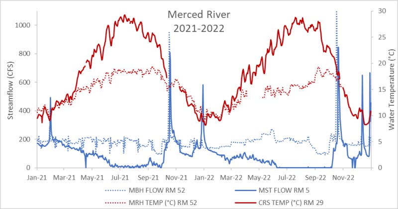 Figure 4. Merced River streamflow (cfs) versus water temperature (°C) at the uppermost and lowermost gauges for years 2021-2022. Streamflow: MBH at RM 52, and MST at RM 5. Temperature: MRH at RM 52, and CDEC Cressey Bridge (CRS) at RM 29.
Fall-run Chinook escapement surveys for the Merced, Tuolumne, and Stanislaus River begin typically around the first week of October, when adults begin to reach the tributaries after migrating through the bay. In 2022, the Tuolumne and Stanislaus River crews observed the presence of Chinook salmon in late September and early October, and the Merced River crew did not observe any live salmon until the fourth week of October. (Figure 5). Historical Merced River Hatchery data shows that fish have arrived as early as September. In 2022, the Lower Merced River remained disconnected until October 5th, which likely impacted the fall run adult Chinook salmon migrating into the Merced River in 2022. Figure 6 (a and b) provides a visual representation of the Merced River channel transformation at RM 2.5 between wetted and drying phases from May to November of 2022.
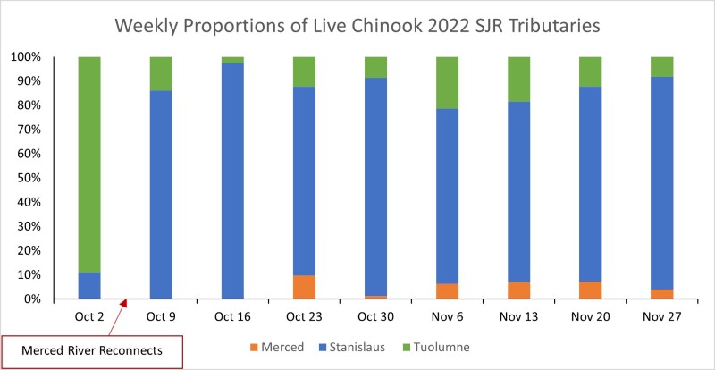 Figure 5. Weekly proportions (October-November) of live fish recorded during the 2022 escapement surveys for the Merced, Tuolumne, and Stanislaus River.
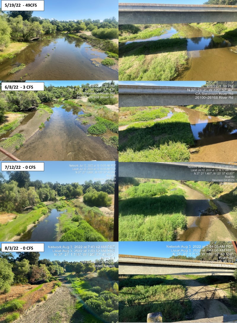 Figure 6a. Photos taken from Hatfield Park bridge facing upstream (left) and downstream (right) indicating periods of time when the river was disconnected and reconnected.
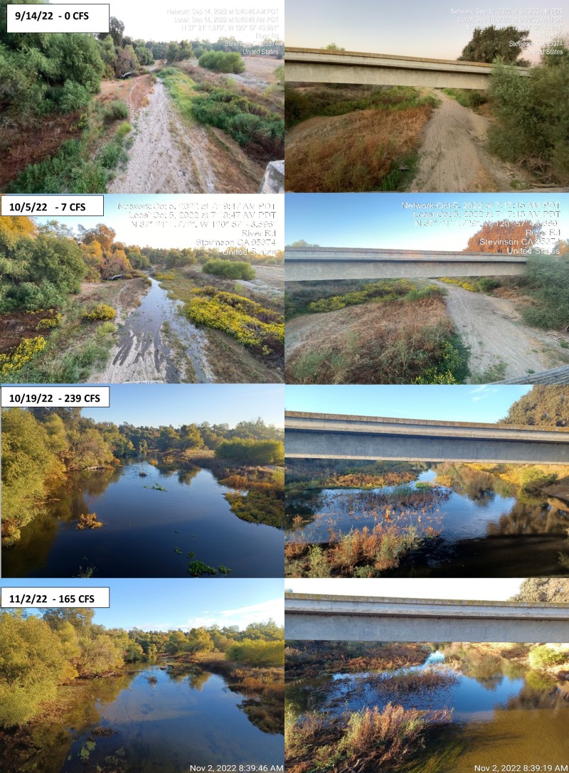 Figure 6b. Photos taken from Hatfield Park bridge facing upstream (left) and downstream (right) indicating periods of time when the river was disconnected and reconnected.
Drought influences the growth and survival of aquatic organisms as well as terrestrial organisms in habitats near river channels. It has the potential to cause a reduction or elimination of flowing water, leading to the loss of physical habitat and factors that maintain healthy water quality. The macro-invertebrates and fish communities inhabiting a river channel impacted by a drought (i.e., increasing water temperatures and decreased water quality), often shift toward populations that can better withstand these harsh conditions (Lake P.S 2003). Consistent stream monitoring is critical to determine the impact of drought on aquatic communities and their habitat. Further knowledge and understanding of these processes help us to make scientifically based decisions to protect and improve aquatic habitat, while maintaining the health and availability of California’s fisheries resources (Atkinson et al. 2018).
Works Cited
- Atkinson, K. (2018). Statewide Drought Response: Stressor Monitoring: Summary Report (2014-2017).(opens in new tab) California Department of Fish and Wildlife.
- California Data Exchange Center(opens in new tab). 2022. California Department of Water Resources.
- California Natural Diversity Database (CNDDB). July 2023. State and Federally Listed Endangered and Threatened Animals of California.(opens in new tab) California Department of Fish and Wildlife. Sacramento, CA
- California Regional Water Quality Control Board (CVRCB). 2019. Water Quality Control Plan for the California Regional Water Quality Control Board Central Valley Region.(opens in new tab) Revised February 2019.
- Henry, L. 2022. Bakersfield Sued Over “Dewatering” of Kern River.(opens in new tab) SJV Water. November 30,2022.
- Heyne, T., Atkinson, K., and Benson, H. (2016). Drought Stressor monitoring case study: Steelhead abundance during high temperatures in the Lower Merced River. California Department of Fish and Wildlife.
- Lake, P.S. (2003). Ecological effects of perturbation by drought in flowing waters.(opens in new tab) Freshwater Biology. 48: 1161-1172.
- Tsao, S., Mandrup, M., and Atkinson, K. (2016). Drought stressor monitoring case study update: Merced River Drought. California Department of Fish and Wildlife.
- Stanley, E. H., Fisher, S. G., and Grimm, N. B. (1997). Ecosystem Expansion and Contraction in Streams.(opens in new tab) Bio Science. 47(7), 427–435.
Prepared by:
Alisa Dahl, CDFW
Christopher Diviney, CDFW
Gretchen Murphey, CDFW