Lower Merced River/Merced County
Species / Location
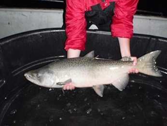 Figure 1A. Chinook salmon.
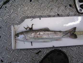 1B. Steelhead Trout.
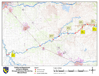 Figure 2. Lower Merced River Drought Stressor Monitoring Map. Yellow diamonds indicate where flow data is collected, red crosses indicate the location of the temperature data-loggers, and the pink line marks the snorkel survey area.
The Merced River is the southern-most extent in the Central Valley of self-sustaining populations of two fish species in the salmon family: fall-run Chinook salmon (Oncorhynchus tshawytscha) and winter-run steelhead (Oncorhynchus mykiss) (Figure 1A and 1B). Population surveys done over the last ten years estimate the number of Chinook salmon in the Merced River to be between 400 and 4,000 adults. The population of steelhead in the Merced River is largely unknown due to lack of population data. To provide better estimates of these two species, the California Department of Fish and Wildlife (CDFW) focused monitoring efforts on the lower Merced River from the confluence with the San Joaquin River upstream to the Crocker-Huffman Dam (Figure 2).
Need for Drought Stressor Monitoring
California declared a state of emergency due to the long-term drought and established water conservation and monitoring measures. The drought conditions raised concerns over the loss of steelhead during the summer in the upper reaches of the anadromous section of the Merced River. Through temperature monitoring and population surveys of anadromous salmonids, CDFW can gather valuable information necessary to determine population status and health as well as plan for emergency fisheries management actions (e.g. planning of fish rescues and recreational fishing closures).
Stressor Monitoring Efforts
CDFW downloaded data from 11 water temperature monitoring stations and three river flow gages in the lower Merced River from the confluence with the San Joaquin River upstream to the Crocker-Huffman Dam (Figure 2). Data was downloaded every two months, except at the four downstream locations where data was downloaded every two days during the spring and summer of 2014 and 2015. This increased frequency of temperature data retrieval and flow analysis from California Data Exchange Center allowed CDFW to make management decisions using real-time data during the worst part of the drought. Fish abundance surveys during this time period provided important information about effects of drought on Chinook salmon and steelhead (Figure 3a and 3b).
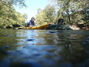 Figure 3A Crews performing snorkel fish counts in Merced River. CDFW photo
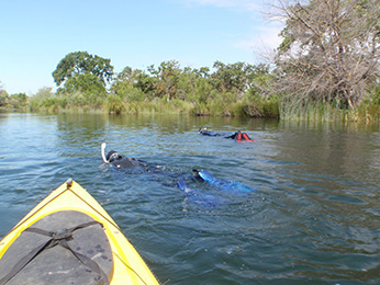 Figure 3B Crews performing snorkel fish counts in Merced River. CDFW photo
Findings
The six-mile river reach located just downstream of Crocker-Huffman Dam is generally considered to be the best steelhead habitat in lower Merced River. Temperature analysis shows that even this reach had become less tolerable for steelhead during the summers of 2014 and 2015, especially in 2015 when it was frequently above 20°C. Just below the dam, the warmest daily average temperature was determined to be 21.9°C (on September 22, 2015). Warm temperatures released from dams are problematic at the Merced River because the entire downstream reach is affected by these releases and data shows that river temperature increases with distance downstream. Of the entire length of river surveyed, the warmest daily average water temperature (29.8°C) was determined just upstream of the Santa Fe Avenue Bridge [River Mile (RM) 28]. Between the confluence with the San Joaquin River (RM 4) and the Santa Fe Avenue Bridge (RM 28), water temperature ranged in from 25°C to 30°C (Figure 4). Drought conditions added additional stress on top of a system that was already subjected to water diversions for agricultural use in the lower Central Valley. This caused further impacts on fall-run Chinook salmon and winter-run steelhead populations.
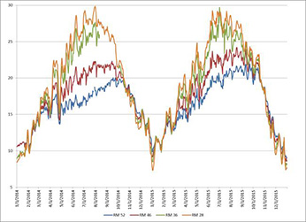 Figure 4. Temperature across 2014 and 1015 at four locations from the middle reach of the Merced River (RM28) upstream to the Crocker-Huffman Dam at River Mile (RM) 52. The four locations, ordered in upstream direction, include RM 28 (orange), RM 36 (green), RM 46 (red), and RM 52 (blue). (click/tap to enlarge)
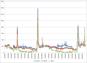 Figure 5. Flow measurement at three locations, ordered in upstream direction: RM 4 (green); RM 46 (red); RM 52 (blue). (click/tap to enlarge)
During the summer and fall of 2014 and 2015, the flow of Merced River became disconnected, measuring 0 cfs, possibly stranding fish and blocking immigration of fall-run Chinook salmon for spawning (Figure 5). Data obtained through fish surveys confirmed population reductions of Chinook salmon and steelhead in 2014 and, further reductions as the drought continued into 2015. In 2014, CDFW documented the following: 742 adult and juvenile steelhead; 14 adult Chinook salmon; and 9,046 juvenile Chinook salmon. In 2015, CDFW reported the following counts: 59 adult and juvenile steelhead; one adult Chinook salmon; and 34 juvenile Chinook salmon (Table 1).
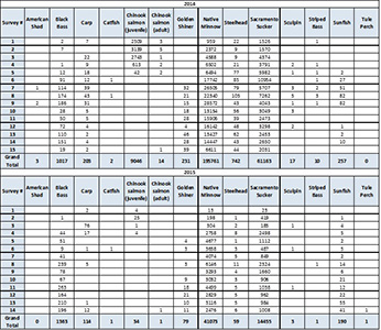 Table 1: Fish observation in fish abundance surveys from 2014 and 2015 (Giudice, 2015).(click/tap to enlarge)
Future Efforts
The combination of temperature monitoring and routine fish population surveys in the Merced River allowed CDFW to make science-based decisions in an emergency response to protect steelhead and Chinook salmon through fisheries management actions including fish rescues in 2014 and in-river fishery closure in 2015.
To protect and restore steelhead populations in the Merced River, CDFW plans to continue the snorkeling surveys. Tracking population status and distribution over time throughout the river allows for a better understanding of fish population health, how habitat is used (and thus how to improve habitat), as well as steelhead movement in response to changing environmental conditions. This information will allow CDFW to more effectively and efficiently restore the steelhead population. Ability to continue this work will be dependent on future funding.
References