Overview
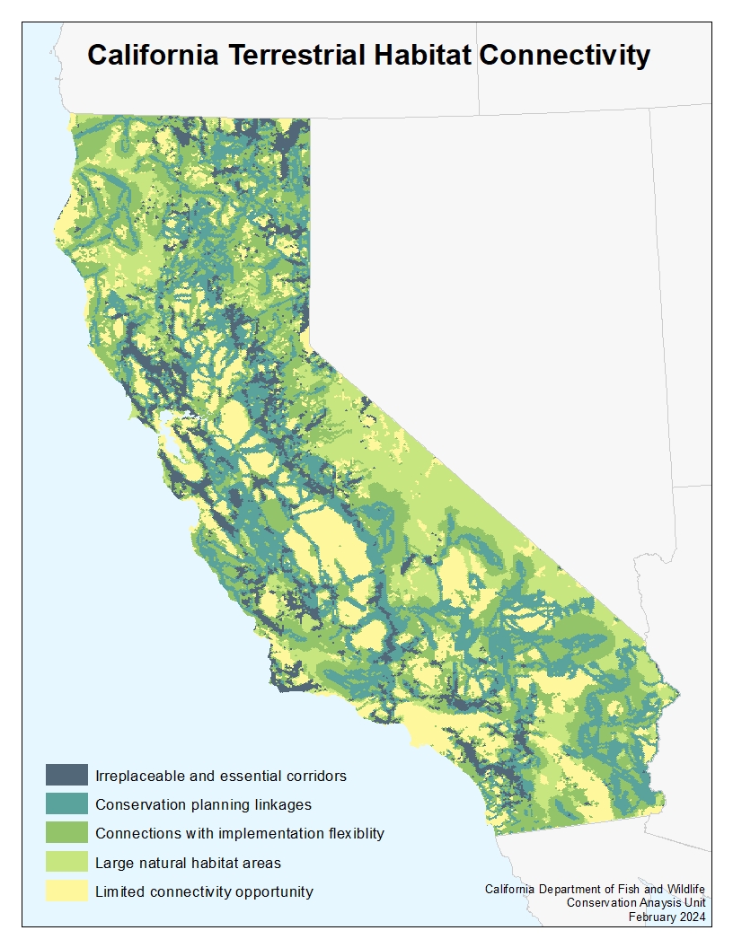
In 2018, the California Biodiversity Initiative Roadmap (PDF) directed CDFW to develop an updated statewide habitat connectivity map. To accomplish this, CDFW combined California Essential Habitat Connectivity (CEHC) linkages developed at a statewide scale (Spencer et al. 2010) with available regional linkage models. Other data sources informing this effort include Terrestrial Landscape Intactness (Degagne et al. 2016) which provides an index of multiple anthropogenic disturbances, and Omniscape, an ecological flow model (TNC and CSP 2018). The resulting Statewide Terrestrial Connectivity map (PDF), part of the CDFW Areas of Conservation Emphasis (ACE) project, presents a view of connectivity across the state using the ACE hexagon grid, a statewide tessellation of 2.5 sq. mile hexagons. Each hexagon contains attributes identified across multiple studies and is then assigned to one of five ACE connectivity classes and accompanying ranks, indicating the relative importance of each area to providing opportunities for the movement and dispersal of organisms critical to maintaining healthy populations and species survival.
As with all ACE model products, the Terrestrial Connectivity Map represents a snapshot in time. CDFW is currently working to fill remaining data gaps with additional fine-scale linkage studies across the state and modeling corridors of large, highly mobile species using GPS collar data. The map will be updated over time as new data become available.
ACE datasets, as well as statewide and regional connectivity datasets, are available for viewing and download through BIOS, the CDFW spatial data library and interactive viewer. CDFW Fish Passage Priority datasets are also available. These datasets have been preloaded into specially curated versions of the BIOS data viewer, accessible through the above links.
ACE Terrestrial Connectivity Factsheet: Terrestrial Connectivity [ds2734] (PDF)
References
- Spencer, W.D., P. Beier, K. Penrod, K. Winters, C. Paulman, H. Rustigian-Romsos, J. Strittholt, M. Parisi, and A. Pettler. 2010. California Essential Habitat Connectivity Project: A Strategy for Conserving a Connected California (PDF). Prepared for California Department of Transportation, California Department of Fish and Game, and Federal Highways Administration.
- Degagne, R., J. Brice, M. Gough, T. Sheehan, and J. Strittholt. 2016. Terrestrial Landscape Intactness 1 km, California. Conservation Biology Institute, December 2016.
- The Nature Conservancy (TNC), California Chapter and Conservation Science Partners (CSP). 2018. TNC Omniscape Connectivity Web Map.