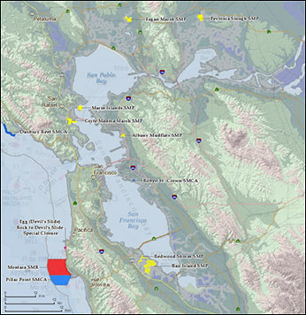
 San Francisco Bay MPAs
(click to enlarge).
Updated March 1, 2016
San Francisco Bay marine protected areas are located within San Francisco Bay, from the Golden Gate Bridge northeast to the Carquinez Bridge. The bay is the fifth and final study region for consideration under the Marine Life Protection Act (MLPA). To help ensure the success of any new or modified San Francisco Bay MPAs, the MLPA planning process may only occur here subsequent to the completion of historic ecosystem restoration and water supply reliability planning efforts in the Sacramento-San Joaquin River Delta. MPAs presented here were established prior to 2007, and were not a part of the MLPA planning effort. See the April 2012 message from Resources Secretary John Laird and California Department of Fish and Wildlife Director Chuck Bonham regarding MPA planning for San Francisco Bay.
MPA Regulations and Maps
MPA maps and current regulations are presented here by coastal county. The JPG maps are low-resolution files that can be quickly viewed on most computers. The PDF maps are higher-resolution files, providing greater detail and clarity. Regulations are taken from California Code of Regulations (CCR) Title 14, Section 632California Code of Regulations (CCR) Title 14, Section 632.
Note: Map Datum used is North American Datum 1983 (NAD83) and position format is in Degrees Minutes Decimal Minutes (DDD MM.MMM). MPA boundaries shown in these maps do not replace the official boundaries found in CCR Title 14, Section 632(b)CCR Title 14, Section 632(b).
Map of San Francisco Bay MPAs (all): JPG(opens in new tab) | PDF(opens in new tab)