Introduction
Fish and Game Code section 1927.3, subdivision (a)(1)
Please read the instructions in their entirety before conducting the census. CDFW recommends printing out this page for reference if working in an area with poor cell phone reception.
To obtain a permit for incidental take of western Joshua tree (WJT) through the Western Joshua Tree Conservation Act (WJTCA), the permittee must submit to CDFW for its approval a census of all WJTs on the project site, including any dead trees. To expedite review, the census should include a data table containing the information requested below, a photograph of each WJT, and a map showing where all WJTs are in relation to other trees and the project site.
PDF Census Instructions
PDF Census Instructions (Spanish)
Project Site and Census Area
Identify the project site. For the purposes of the census, the project site is defined as the area(s) where project activities are expected to occur (e.g., access, staging, construction, etc.). The census area is defined as the project site plus an additional 15- meter (~50 ft) census buffer around the project site. If the census buffer area extends onto neighboring properties, landowner(s) permission should be obtained, whenever possible, to document any WJTs on adjacent properties. If you cannot accurately gather data and photographs of trees within the buffer due to private property issues, please note that in the census.
Conducting the Census
If the census area is large or contains many shrubs, start in one corner and systematically search the entire area using parallel survey transects to ensure thorough coverage.
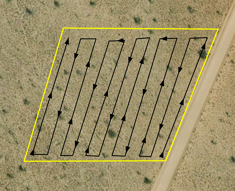 Figure 1. Example of using parallel survey transect methods to thoroughly search a census area (shown in yellow).
Be aware that small WJTs often sprout underneath shrubs (see Figure 2) or at the base of burned trees. All shrubs and burned trees should be thoroughly checked.
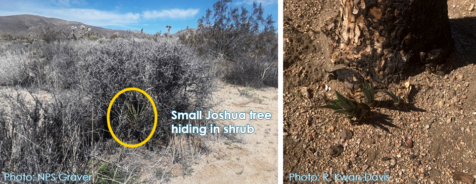 Figure 2. Inconspicuous WJTs sprouting underneath shrubs and at the base of burned WJTs.
Measuring Trees
The census must include size information that categorize WJTs according to the following size classes:
- Less than one meter in height
- One meter or greater but less than five meters in height
- Five meters or greater in height
Each WJT stem or trunk arising from the ground must be considered an individual tree requiring mitigation, regardless of its proximity to any other WJT stem or trunk (Fish & G. Code §1927.3, subd. (b)). Figure 3 shows an example of how a cluster of WJTs should be counted. Each stem or trunk should be recorded as a separate tree with its own unique identifier. Note: Dead trees must be included in the census. A tree is considered dead if it meets one of the following conditions:
- Has not burned and has no green leaves, no new growth on the main stem, and no sprouts at the base;
- Has partially or fully burned at least 18 months prior, has no green leaves, no new growth on the main stem, and no sprouts at the base;
- Has fallen and is completely detached from its roots or has fallen and its roots are no longer in contact with the soil.
If the dead tree is still standing and completely intact, it should be measured in the same manner it would have been had it still be alive. If the dead tree is not standing or not completely intact, the longest intact portion of dead vegetative material associated with the stem of the tree should be measured, regardless of whether it is standing, fallen, or detached. Due to uncertainty in knowing the prior arrangement of the detached limbs, detached limbs should not be added to each dead individual's length measure measurement. Detached vegetative material is considered part the individual it came from, and the removal of this vegetative material should therefore be authorized by the permit as long as the mitigation fee is paid for take of that individual.
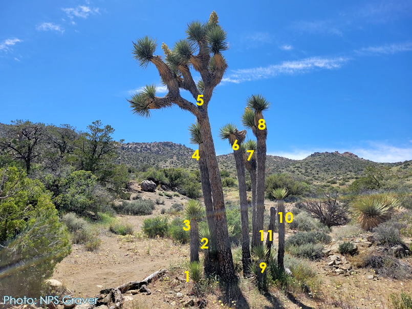 Figure 3. Cluster of WJTs with each individual labeled separately.
Using a sturdy tape measure, measuring pole, or some kind of marked pole, measure each tree from the middle of the base of the trunk to the top of the leaf that is furthest away from the base. Do not measure leaning trees perpendicular to the ground. Do not include current flower clusters or old flower stalks. See Figure 4 for an example.
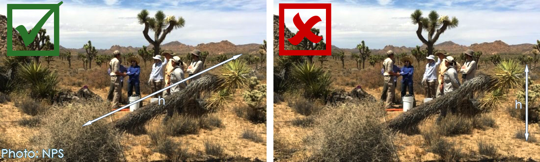 Figure 4. How to measure a leaning tree.
The main trunk may follow an unusual path. In these cases, two measurements should be made to capture the true growth of the tree. No more than two measurements should be taken (see Figure 5).
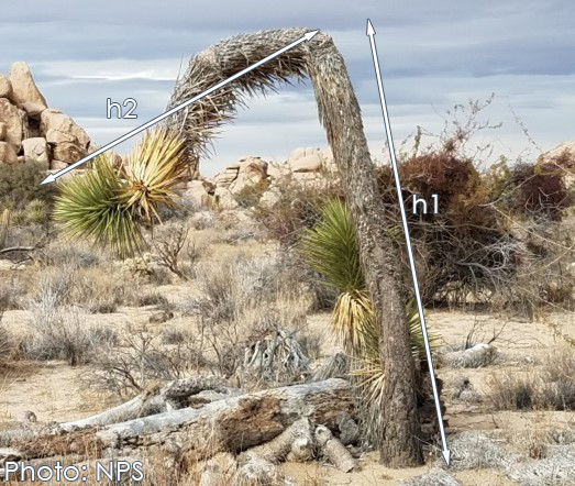 Figure 5. Example of a WJT with an unusual growth pattern. One measurement should be made along the main trunk and one more measurement should be made following the direction of the main branch.
Other Tree Information
Mature Trees
Mature trees are defined as trees which have produced flowers/fruits in the past. This is easy to identify because WJT only branch after flowering. Record “Yes” in the “Mature Tree?” column if the tree has at least one set of branches. Record “no” if the tree only has a single, unbranched stem/trunk.
Flowers/Fruits
Flowers and fruits may be apparent at the time of census data collection. Flowers emerge from the ends of the branches in clusters that are white or greenish white (Figure 6). Young flower buds may have a red or maroon set of leaves (bracts) surrounding the flower cluster. Record any clusters or buds as “flower” in the data sheet. WJT fruits, or seed pods, usually begin to emerge from the flowers between June to August. They are green and cylindrical at first and fade to tan or brown when they ripen (Figure 6). Fruits that contain viable seeds usually stay on the tree for no more than a few months; only record “fruit” in the census table if they are from this year’s growing season. Do not record old fruits that are dark brown or small/undeveloped. If fruits are starting to develop while flowers are still present, record the tree as having “fruit.”
Note: This information will help CDFW determine if seed collection is possible to help minimize impacts to the population.
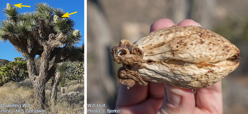 Figure 6. Example of WJT flowers and fruits.
Photographs
Provide at least one color photo of each WJT in the census. Stand far enough away from the tree so that the entire tree fits in the picture frame. Include a scale in the photo if possible (see Figure 7 and 8). If the WJT is a cluster of trees as in Figure 9, each tree in the cluster needs a separate photo. If there are multiple trees in the photo, indicate which tree is being photographed by placing an object (measure stick, broom, flagging, etc.) on or next to tree (Figures 7, 8, and 9).
Include the unique identifier (matching the census table) in each file name. For example: WJT1.jpg
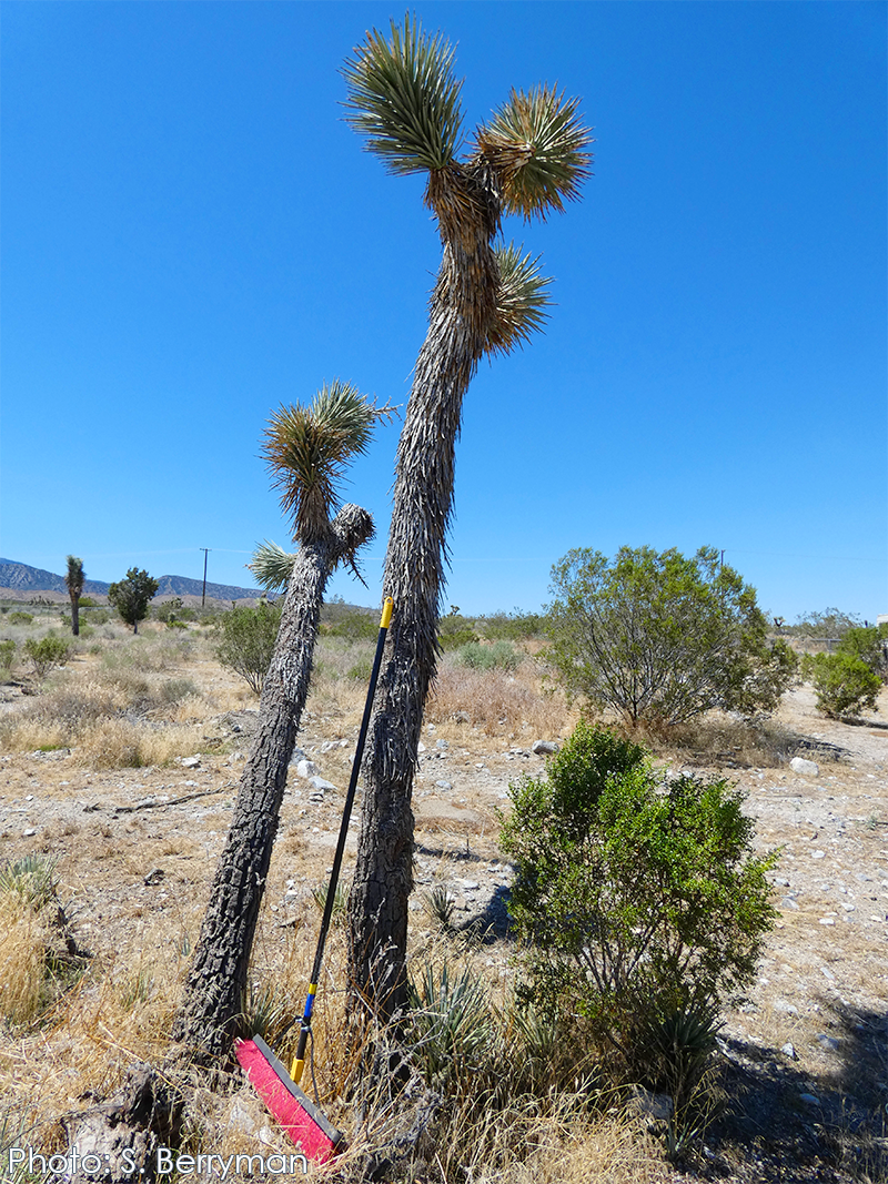 Figure 7. Example of using a broom handle to indicate which WJT in the census table the photo refers to.
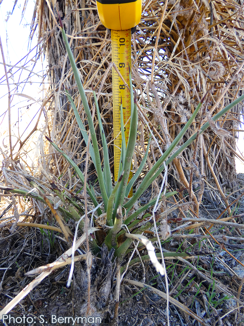 Figure 8. Example photo of a small WJT with tape measure for scale (optional)
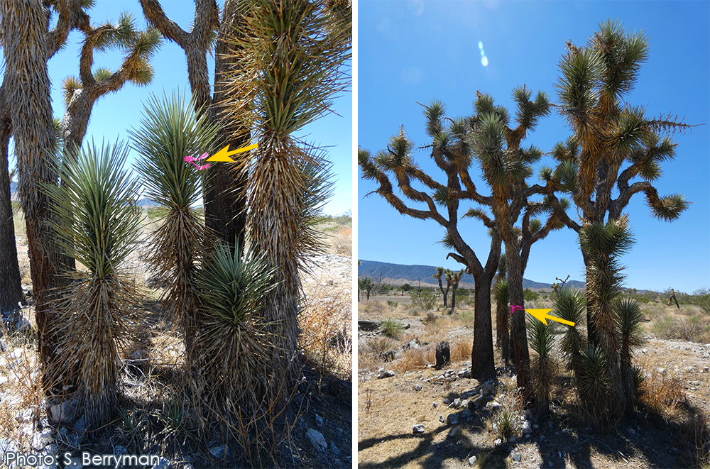 Figure 9. Examples that use flagging to indicate which WJT in the census table the photo refers to.
WJT Census Data Sheet
WJT Census Data Sheet spreadsheet template (Excel)
Including the following information in your census will help expedite CDFW’s review.
- Census Information
- Project Name and Permittee name
- Project Address/APN or Location Description
- Datum of the coordinates (usually WGS 84)
- Project Site boundary corners (Lat/Long)
- Name, business (if applicable), title (e.g., botanist, property owner, etc.), and contact information for the person who prepared the census
- Date(s) census was performed
- Any other site condition notes
- WJT Census Table
- Provide the unique identifier for each tree corresponding to the map
- Provide GPS location for each tree (latitude and longitude)
- Indicate the size class for each tree as follows:
- Size Class A is any WJT less than one meter in height
- Size Class B is any WJT one meter or greater but less than five meters in height
- Size Class C is any WJT five meters or greater in height
- For each tree, include the actual height of the tree to the nearest 10th of a meter (0.1 meters). Including this data is optional.
- For each tree, indicate whether is “live” or “dead”.
- For each tree, indicate “yes” or “no” whether it is a mature tree (a branched tree is considered mature).
- For each tree, indicate whether the tree is currently producing flowers, fruits, or none.
- For each tree, indicate how the tree will be impacted (removal, trim, relocation, other, or none).
- Indicate the distance from tree to project activities, measuring from the base of the tree.
- Include proposed relocation site (if applicable).
Census Map
Google Earth can be used to make a census map and is available in different versions (Google Earth on web, Google Earth on mobile, or Google Earth Pro on desktop). Note: CDFW uses decimal degrees and WGS 84 datum. See the following tips for creating a quality census map:
For small projects (less than 10 trees), hand drawn maps are also acceptable as long as they contain all of the elements listed above.
If you need assistance creating a map, contact your local Regional office.
Submission Instructions
Once the census is complete, submit it along with the WJTCA ITP Application form (Word) and all other required documents to the Regional Office. See process instructions for details.
Survey123 Form
For large data packages with many photos, you can download Survey123 from the App Store (iOS) or Google Play (Android) and scan the QR Code in app to download the CDFW Western Joshua Tree Census form. Refer to Survey123 Census Instructions (PDF) for guidance.