2026 Recreational Ocean Salmon Regulations
In-season Recreational Tracking
Sport Ocean Salmon Tracker.
Spring/Summer Season Regulations
Minimum size limit: 24 inches total length through May 15 and 20 inches total length thereafter.
Inseason action may be taken to close open days when total harvest is approaching the area specific harvest guideline.
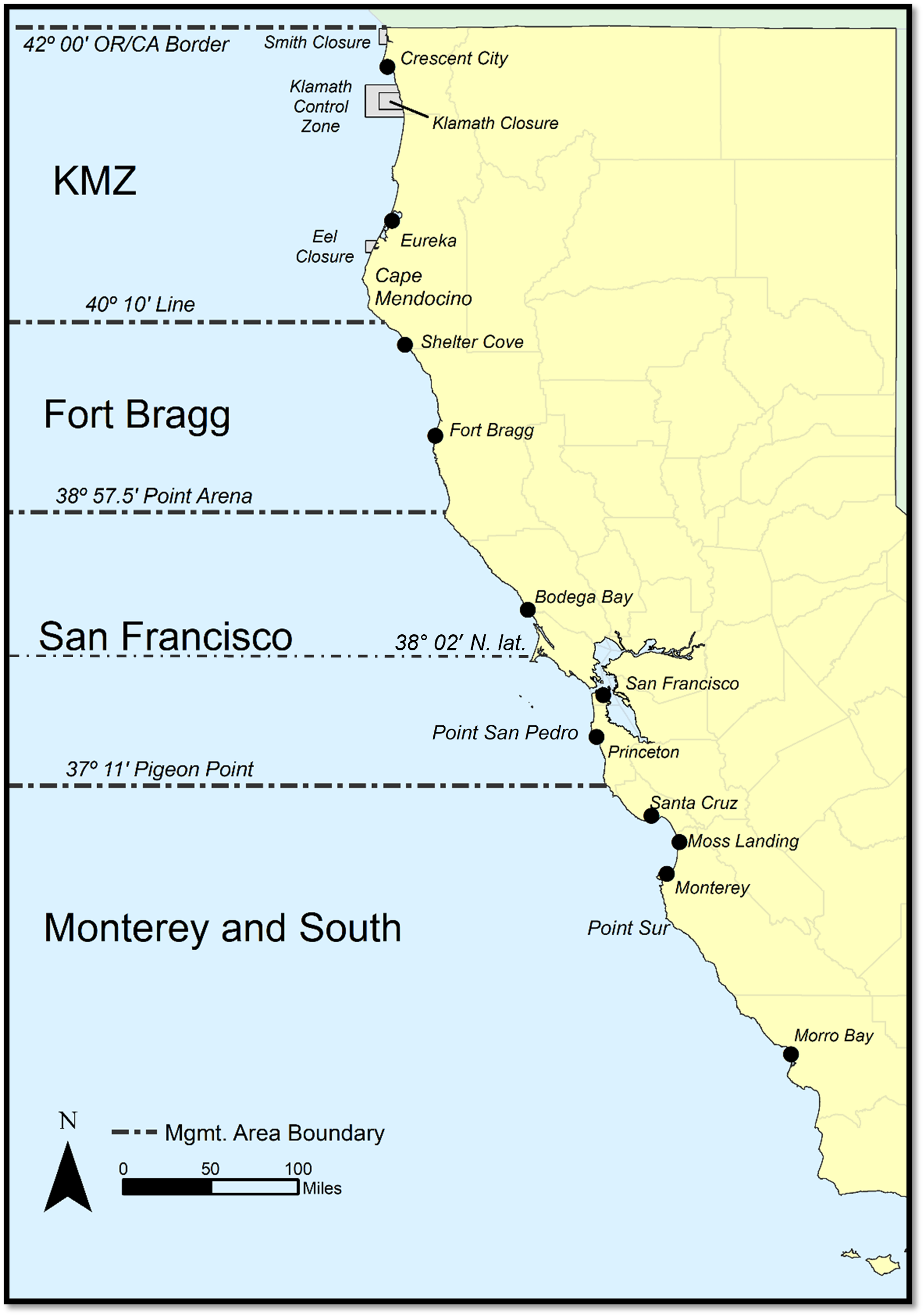
OR/CA Border to the 40º10' Line (KMZ)
- June 13-July 19, August 1-31 - Harvest Guideline: 3,900 Chinook
40º10' Line to Point Arena (Fort Bragg)
- June 13-July 19, August 1-31 - Harvest Guideline: 5,100 Chinook
Point Arena to Pigeon Point (San Francisco)
- June 27- July 22, August 1-31 - Harvest Guideline 34,900 Chinook
Pigeon Point to the U.S./Mexico Border (Monterey and South)
- April 11- August 31 - Harvest Guideline: 21,800 Chinook
Fall Season Regulations
Fall harvest guideline (applicable across open areas): 20,000 Chinook; Minimum size limit: 20 inches total length.
Inseason action may be taken to close open days when total harvest is approaching the fall harvest guideline.
38º02' N. lat. to Pigeon Point Subarea
Pigeon Point to the U.S./Mexico Border (Monterey and South)
General Sport Regulations
- Daily bag limit (CCR T-14, §27.80): 2 salmon of any species except coho (silver) salmon.
- Possession limit: No more than two daily bag limits may be possessed when on land. On a vessel in ocean waters, no person shall possess or bring ashore more than one daily bag limit (CCR T-14, §27.80(e)).
- Retention of coho (silver) salmon or steelhead trout is prohibited in any ocean fishery (CCR T-14, §27.70(b) and §27.80(b)).
- Salmon may not be filleted on any boat or prior to being brought ashore (CCR T-14, §27.65(c)).
- Salmon may only be taken by angling as defined in CCR T-14, §1.05. No sinkers or weights exceeding 4 lbs. may be used, except that a fishing line may be attached to a sinker or weight of any size if such sinker or weight is suspended by a separate line and the fishing line is released automatically by a mechanical device from the sinker or weight when any fish is hooked (CCR T-14, §27.80(a)).
- Transit provisions: No fishing gear may be deployed in an area where salmon fishing is closed and salmon are possessed. Coho may not be possessed on board in the KMZ, and Chinook may be possessed only when the season is open in this area.
- Special Salmon Closures (CCR T-14, §27.75):
 Smith Closure Map.
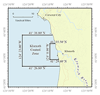 Klamath Closure Map.
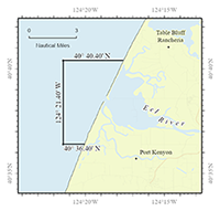 Eel Closure Map.
- Smith River mouth - closed year-round
- Klamath River mouth - closed year-round; in August, this closure expands("Klamath Control Zone")
- Eel River mouth - closed in August and September Only
- North of Point Conception: No more than two single-point, single-shank barbless hooks shall be used and no more than one rod per angler when fishing for salmon or fishing from a boat with salmon on board (CCR T-14, §27.80(a)).
- 40º10' line near Cape Mendocino to Point Conception (CCR T-14, §27.80(a)): When fishing with bait and angling by any means other than TROLLING1, no more than two single-point, single-shank barbless CIRCLE HOOKS 2 shall be used. The distance between the two hooks must not exceed 5 inches when measured from the top of the eye of the top hook to the inner base of the curve of the lower hook and both hooks must be permanently tied in place (hard tied).
NOTE: These special gear restrictions apply to each angler fishing for salmon or fishing from any boat or floating device with salmon on board.
- TROLLING is defined as angling from a boat or floating device that is making way by means of a source of power, other than drifting by means of the prevailing water current or weather conditions.
- A CIRCLE HOOK is defined as a hook with a generally circular shape and a point which turns inwards, pointing directly to the shank at a 90-degree angle.
Recovery of coded-wire tag from salmon head: Any person in possession of a recreationally taken salmon with a missing adipose fin (the small, fleshy fin on the back of the fish between the back fin and tail) shall immediately relinquish the head of the salmon, upon request by an authorized agent or employee of the Department, to facilitate the recovery of any coded-wire tag (CCR T-14, §1.73).
* Klamath Control Zone: The ocean area at the Klamath River mouth bounded on the north by 41°38'48" N. lat. (approximately 6 nautical miles north of the Klamath River mouth); on the west, by 124°23'00" W. long. (approximately 12 nautical miles off shore); and on the south, by 41°26'48" N. lat. (approximately 6 nautical miles south of the Klamath River mouth).
2026 Commercial Ocean Salmon Regulations
In-season Commercial Tracking
Commercial Ocean Salmon Tracker.
Summer Harvest Regulations
Harvest limit of 83,000 Chinook applicable to open areas south of Pt. Arena; Landing limit of 160 Chinook per vessel per open period applies across the combined management areas south of Pt. Arena. Possession limit of 160 Chinook; Minimum size limit: 27 inches total length; All salmon must be landed south of 40°10’ N. lat. and within 24 hours of any closure of the fishery.
Inseason action may be taken to reduce landing limits or close open days when harvest is approaching the summer harvest limit.
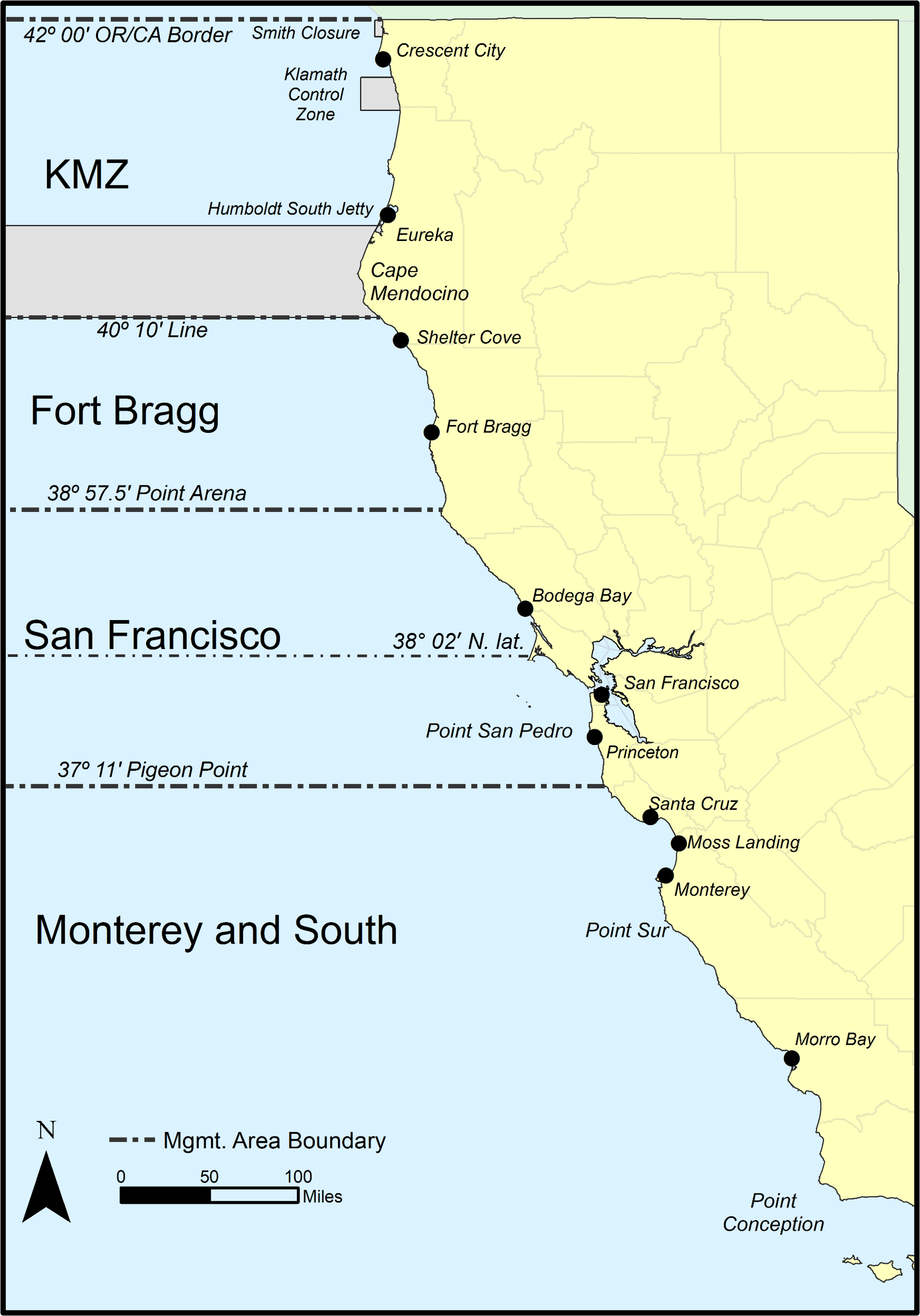
OR/CA Border to the 40º10' Line (KMZ)
40º10' Line to Point Arena (Fort Bragg)
Point Arena to Pigeon Point (San Francisco)
- May 1-6, 9-13, 16-20, 23-29, August 1-7, 13-16, 25-27
Pigeon Point to the U.S./Mexico Border (Monterey and South)
- May 1-6, 9-13, 16-20, 23-29, June 3-8, 12-16, 26-30, July 6-10, 20-24, August 1-7, 13-16, 25-27
Fall Harvest Regulations
Harvest limit of 20,000 Chinook; Landing limit of 100 Chinook per vessel per open period. Possession limit of 100 Chinook; Minimum size limit: 26 inches total length; All salmon must be landed between Pt. Arena and Pigeon Pt. and within 24 hours of any closure of the fishery.
Inseason action may be taken to reduce landing limits or close open days when harvest is approaching the fall harvest limit.
38°02 N. lat. to Pigeon Pt. Subarea:
- September 4-8, 11-15, 18-22, 25-30
General Commercial Regulations
- All salmon except coho; all commercial salmon must be landed in California (CCR T-14, § 182)
- Single point, single shank barbless hooks are required
- No more than 6 lines are allowed per vessel (CCR T-14, §182)
- Electronic Reporting Requirements: Any fish receiver or fisherman with a fisherman's retail license shall record landing information on an electronic fish ticket, including the number of individual fish (CCR T-14, §197). Electronic fish tickets must be submitted within 24 hours of landing. Any person who lands salmon shall keep a copy of all landing receipts documenting salmon landings on board the fishing vessel that caught the salmon until 15 days after the last salmon season closure for the calendar year (CCR T-14, §182).
- Compliance with salmon sampling programs: A person shall relinquish fish or fish parts for the purpose of a biological sample, including heads from adipose fin-clipped salmon for recovery of the Coded-Wire Tag (FGC §8226; §7711).
- Transit through closed area with salmon on board: It is unlawful for a vessel to have fishing gear in the water while transiting any area closed to salmon fishing while possessing salmon (CCR T-14, §182).
- Barbless circle hooks1 required when fishing with bait by any means other than trolling2
- A CIRCLE HOOK is defined as a hook with a generally circular shape and a point which turns inwards, pointing directly to the shank at a 90-degree angle (CCR T-14, §182).
- TROLLING is defined as angling from a boat or floating device that is making way by means of a source of power, other than drifting by means of the prevailing water current or weather conditions (CCR T-14, §182).
NOTE: When Pacific halibut are caught and landed incidentally in the commercial salmon troll fishery under a NOAA issued permit, both the number of Pacific halibut landed and the number of salmon landed must be recorded on the electronic fish ticket. See federal regulations for incidental Pacific halibut harvest requirements and restrictions.