Species and Location
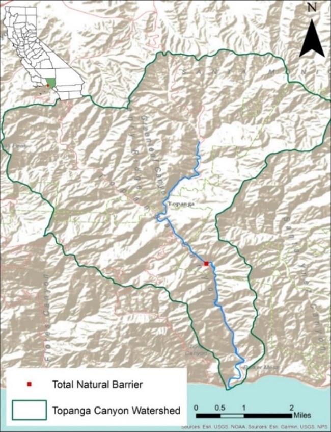 Figure 1. Watershed boundary of Topanga Creek within the Santa Monica Mountains.
Topanga Creek is a small coastal mountain stream located in Los Angeles County originating around 760ft of elevation and traveling 4.5 miles downstream to its confluence with the Pacific Ocean. At 18 square miles, Topanga Creek is the third largest watershed draining into the Santa Monica Bay. Many species of concern call this relatively undeveloped watershed home, including five native aquatic species: state candidate for endangered species (2022) and federally endangered Southern California steelhead (Oncorhynchus mykiss), arroyo chub (Gila orcuttii), federally endangered tidewater goby (Eucyclogobius newberryi), California newts (Taricha tarosa) and western pond turtles (Actinemys marmorata). These native species compete with introduced non-native aquatic species including red swamp crawfish (Procambarus clarkia), red-eared sliders (Trachemys scripta elegans), and an invasive plant species commonly known as Arundo (Arundo donax).
A total natural barrier to the upstream migration of steelhead trout (migrating from the ocean into freshwater known as anadromy) lies approximately three miles upstream of the estuary. Currently, Topanga Creek is the only stream in the Santa Monica Mountains that contains an anadromous population of O. mykiss. The most recent steelhead redd in Topanga was observed in 2014 and the last sighting of a steelhead within the Santa Monica Mountains occurred in 2017. Snorkel surveys conducted throughout the Santa Monica Mountains between 2018-2021 confirm an absence of O. mykiss outside of Topanga Creek.
Need for Drought Stressor Monitoring
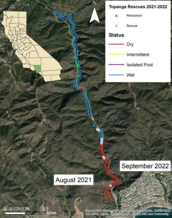 Figure 2. Wet and dry habitat of Topanga Creek moving upstream of the estuary to the natural anadromous barrier recorded in August 2021 and September 2022. The same areas dried each year, providing insight into which areas rescues should be focused versus which areas are consistently suitable for holding fish over summer. Fish rescues (white circle) occur in lower reaches where the creek dries. These fish are moved to the upper watershed (relocation – green triangle) where they will survive through summer.
Drought monitoring in Topanga Creek is essential to understanding the impacts of reduced rainfall on Topanga Creek and the species that inhabit it. Since 2012, less than average rainfall (excluding 2017) resulted in reduced habitat connectivity and rearing space for native fish, ultimately leading to population decline. In September 2022, Topanga Creek reached its driest point of the year with only 1.92 miles out of 3.04 miles of the anadromous portion of stream being wetted (63.1%; Figure 2). In 2021, conditions were even drier with only 1.84 miles (60.5%) wetted in August. As we approach spring and summer each year, reduced baseflows can lead to drying of large portions of the lower river. The amount of drying can be made worse by ongoing long-term drought conditions. Over summer, when portions of the stream become intermittent or dry entirely, deep perennial pools with groundwater seeps in the upper watershed provide essential habitat for O. mykiss to survive. Understanding where these areas of refugia are located while monitoring the water quality of these pools is essential for protecting O. mykiss during drought years and can help guide future rescue efforts.
Stressor Monitoring Efforts
CDFW staff operates a life cycle monitoring station in Topanga which includes use of a DIDSON camera, Passive Integrated Transponder (PIT) tag array, and yearly PIT tagging efforts. Additional monitoring is performed through redd surveys and drought monitoring surveys. Every 2-4 weeks, five different stations along the first 2.5 miles of stream are visited to monitor discharge, water quality, and pool metrics. From May to November, as parts of the stream dry, walking surveys are conducted to identify O. mykiss that may be stranded and need to be relocated upstream. GPS locations are collected at each point that the stream goes wet or dry to assess the extent of drought effects. In winter and spring, redd surveys are completed to document the location and number of O. mykiss spawning sites throughout the stream. A PIT tag array deployed near the estuary captures the upstream and downstream movement of any tagged O. mykiss, while a DIDSON underwater sonar camera records any fish moving upstream from the ocean. Finally, the status of the Topanga estuary is monitored year-round.
Findings
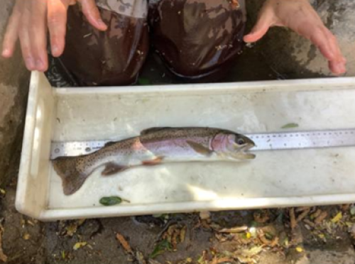 Figure 3. Rescued O. mykiss PIT tagged and relocated upstream in Topanga Creek, April 2022.
In April 2022, stream flow began to decrease causing the levels of dissolved oxygen (needed for fish to survive) to drop. The stream became disconnected, and some isolated pools became unsuitable for steelhead rainbow trout survival. In response, CDFW staff conducted three rescues between April and September to relocate stranded O. mykiss from isolated pools in the lower stream to perennial habitat upstream. On April 12, two O. mykiss were rescued and PIT tagged; they measured 216mm and 335mm. These fish were found in an isolated pool that was less than 0.5ft deep (Figure 3). On May 16, three O. mykiss ranging from 163mm to 229mm were relocated upstream. The two larger fish of the group were previously tagged recaptures that were measured to have growth rates of 6mm/month and 7 mm/month. Lastly, on September 22, thirteen more O. mykiss were rescued from various isolated pools and measured 52mm to 184mm. The first rescue pool visited was located 1.1 miles upstream from the estuary, a regularly monitored site. Staff rescued four of the thirteen O. mykiss and over twenty arroyo chub in the unit with no inflow or outflow present (Figures 4 & 5). By September 2022, the stream reached its driest point and the areas that remained wetted were likely perennial.
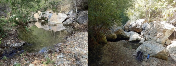 Figure 4. A photo comparison of a pool located 1.1 miles upstream from the Topanga estuary. Left photo was taken mid-February 2022. The photo on the right was taken in September 2022, days before a rescue effort was completed. Four trout were rescued from this pool, measuring 52, 68, 152, and 184mm. Reduction in pool size and volume show the impact of lower-than-average rainfall during the spring and summer months.
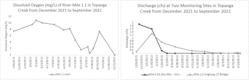 Figure 5. (Left) A graph depicting dissolved oxygen (mg/L) at a monitoring pool located approximately 1.1 miles upstream of Topanga’s estuary. The Mile 1.1 pool was the downstream most wetted location for most of the summer and fall months in 2022. (Right) A graph depicting stream discharge of two monitoring sites in Topanga Creek. Mile 0.25 has remained dry since March 2022.
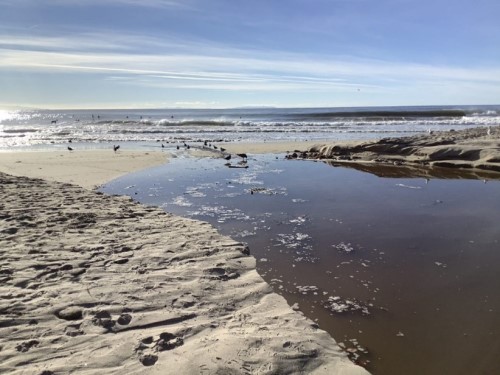 Figure 6. Topanga's estuary breaching, December 2021.
For the winter of 2021-2022, the Topanga Creek estuary connected to the ocean after late December 2021 rainfall and remained connected through January 2022 (Figure 6). In February 2022, breaching only occurred during high tides, and in late March breaching occurred for approximately two weeks after a rainstorm. The estuary provides an important link between the stream and the ocean for smolting O. mykiss. O. mykiss will sometimes use the estuary to over-summer and grow before leaving to the ocean and it’s important to monitor the water quality to ensure their survival as well as the federally endangered tidewater goby.
A DIDSON camera monitored Topanga Creek a quarter mile upstream from the estuary while it was breached from December 23, 2021 through January 20, 2022 and then again from March 28, 2022 to March 31, 2022, providing a look at upstream and downstream movement of O. mykiss in the area. Thirty days of DIDSON footage was recorded with a consistently high detection efficiency. Due to a technical failure, only 21 days were available for analysis. A total of 79 observations of O. mykiss were documented on DIDSON footage, but biologists determined that none of the upstream O. mykiss observations met the fish and game code of 40cm for steelhead (FGC § 5.88). Based on the DIDSON footage, CDFW biologists determined that the overall downstream movement of fish, in tandem with PIT tag array results, suggests that part of the population is producing smolts.
Future Efforts
CDFW staff will continue to monitor Topanga Creek drought conditions and complete fish rescues as needed. In addition to current monitoring techniques, temperature and dissolved oxygen loggers will be placed in Topanga to better understand how stream conditions vary seasonally. Consistent monitoring will ensure the best perennial habitat can be determined in future drought conditions. On a broader scale, CDFW staff will continue to monitor other Santa Monica Mountain streams under these drought conditions. Streams that meet criteria for maintaining healthy fish populations could serve as potential translocation streams in the event of fire or continued drought.
Prepared By:
Emely Romo, Scientific Aid, CDFW
Brian Bales, Scientific Aid, CDFW
Shelley Hunter-Shatsnider, Environmental Scientist, CDFW