San Felipe Creek, San Diego County
Species / Location
Unarmored Threespine Stickleback (stickleback), a subspecies of Threespine Stickleback, (Figure 1) is a state and federally listed endangered species and a State of California Fully Protected Species. Unarmored Threespine Stickleback are scaleless, freshwater fish that grow up to 5 centimeters (2 inches) long and primarily feed on bottom dwelling insects, crustaceans, and snails. Fewer than 300 stickleback reside in an approximately 1 km section of San Felipe Creek (Figure 2). This population was established in 1981 when the California Department of Fish and Wildlife (CDFW) moved approximately 180 stickleback from Soledad Canyon in Los Angeles County to San Felipe Creek (Swift et. al. 1993).
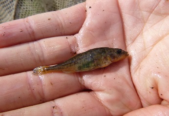 Figure 1. Unarmored Threespine Stickleback, San Felipe Creek, San Diego County. (CDFW photo R. Barabe)
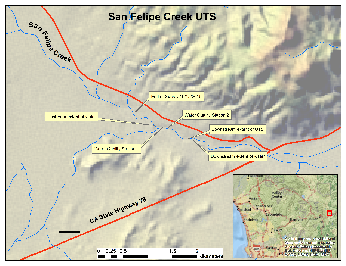 Figure 2. Locations of water quality monitoring stations, survey reaches, and extent of wetted habitat for Unarmored Threespine Stickleback at San Felipe Creek, San Diego County. (Click image to enlarge)
Need for Drought Stressor Monitoring
The largest threats to stickleback in this region are runoff and land destruction created by oil extraction and mining. Other human activities, such as grazing, water discharge, and the introduction of non-native species, have resulted in the extirpation of stickleback from many historically occupied streams (Richmond et al. 2014). Presently, stickleback are restricted to three areas: the upper Santa Clara River and its tributaries in Los Angeles County, San Antonio Creek in Santa Barbara County, and the Shay Creek vicinity in San Bernardino County (Richmond et al. 2014).
Drought conditions throughout southern California have resulted in low water levels, higher than average water temperatures, and dry sections of streams, all of which have directly impacted stickleback (California Department of Water Resources 2014). Two CDFW led rescues of the species occurred in the Santa Clara River Watershed during the summer of 2016: one moved stickleback into an adjacent, formerly occupied drainage and another moved them into a CDFW hatchery near Soledad Canyon. Deteriating conditions within the Santa Clara River Watershed could result in extirpation of Unarmored Threespine Stickleback. If that were to happen, a portion of the stickleback population in San Felipe Creek could be used to repopulate areas where the species has been lost. Monitoring San Felipe Creek is crucial for the long-term survival of the species.
Stressor Monitoring Efforts
Between June 25, 2015 and December 22, 2016, CDFW conducted twenty-one site visits to San Felipe Creek to monitor drought related impacts. Surveys included water quality monitoring, flow measurements, and visual observation of stickleback. A temperature logger was deployed in February 2016 and set to record temperature every hour. CDFW recorded the wetted stream lengths and geographic extent of stickleback on October 2 and October 15, 2015 (Figure 2). More surveys were conducted upstream where dense cottonwood trees indicated the groundwater was present, but no surface water was found. Fish surveys incorporated bankside observation (walking the stream and looking for fish), dip nets (randomly netting areas of dense vegetation), and use of GoPro cameras deployed on the streambed.
Findings
Water quality monitoring (Table 1; Figure 3) illustrates the stability of this spring fed system, as water temperature measurements never exceeded 20°C and dissolved oxygen concentrations rarely fell below 5 ppm during surveys. Continuous temperature monitoring (Figure 4) tells a similar story, although it reveals daily fluctuations of five degrees or more and shows water temperatures reaching 25°C on two occasions in June 2016. These temperature spikes are difficult to explain, as they occurred before peak air temperatures. Flows also showed seasonal variation: an observed low of 0.09 cubic feet per second on June 25, 2015 and a high of 0.83 cubic feet per second on December 22, 2016. Furthermore, dissolved oxygen decreased in December of both 2015 and 2016. This change is likely due to leaves from the cottonwood forest dropping into the stream and increasing the food available to bacteria, which consume oxygen as they decompose plant matter.
Table 1.Water quality data obtained through surveys of San Felipe Creek.
| Date |
Time |
Temperature (C°) |
DO (ppm) |
Conductivity (µS/cm) |
Salinity (ppt) |
pH |
Stream Width (ft) |
Discharge Ft³/Sec |
| 6/25/2015 |
14:02 |
18.4 |
5.99 |
416.7 |
0.23 |
7.27 |
3.9 |
0.098 |
| 7/10/2015 |
9:23 |
16.3 |
6.02 |
584 |
0.35 |
7.52 |
3.9 |
0.462 |
| 8/3/2015 |
9:40 |
18.2 |
6.19 |
653 |
0.37 |
7.48 |
3 |
0.305 |
| 8/19/2015 |
8:03 |
16.4 |
6.69 |
621 |
0.37 |
7.8 |
3 |
0.23 |
| 9/4/2015 |
8:40 |
15.3 |
7.14 |
599 |
0.36 |
7.76 |
3 |
0.25 |
| 10/2/2015 |
9:47 |
14.9 |
7.11 |
596 |
0.36 |
7.8 |
3.1 |
0.19 |
| 10/15/2015 |
9:53 |
17.7 |
6.61 |
634 |
0.36 |
7.87 |
3.2 |
0.29 |
| 10/30/2015 |
9:25 |
9.5 |
8.73 |
516 |
0.36 |
7.9 |
3.2 |
0.325 |
| 11/9/2015 |
9:10 |
9 |
9.06 |
511 |
0.36 |
8.22 |
3.5 |
0.4 |
| 11/19/2015 |
11:45 |
7.2 |
9.23 |
496.5 |
0.37 |
7.99 |
4 |
0.25 |
| 12/11/2015 |
9:30 |
11.4 |
5.03 |
567 |
0.38 |
8.23 |
4.8 |
0.468 |
| 1/15/2016 |
9:15 |
11 |
7.4 |
600 |
0.4 |
8.13 |
4.5 |
0.53 |
| 2/19/2016 |
9:40 |
13.1 |
13.74 |
656 |
0.3 |
7.61 |
12 |
0.58 |
| 3/18/2016 |
9:26 |
12.1 |
14.5 |
707 |
0.3 |
7.45 |
12.7 |
0.7 |
| 6/17/2016 |
9:20 |
14.7 |
No data |
775 |
0.4 |
7.64 |
12.4 |
0.31 |
| 7/8/2016 |
9:30 |
15.9 |
6.02 |
610 |
0.36 |
8.12 |
4 |
0.288 |
| 7/22/2016 |
8:26 |
16.7 |
5.85 |
634 |
0.37 |
8.33 |
3.8 |
0.224 |
| 8/19/2016 |
N/A |
15.01 |
8.01 |
754 |
0.4 |
7.93 |
3.4 |
0.15 |
| 10/19/2016 |
9:07 |
10.14 |
9.65 |
816 |
0.4 |
7.52 |
3.5 |
0.324 |
| 11/17/2016 |
9:55 |
9.69 |
8.3 |
803 |
0.4 |
8 |
3.7 |
0.236 |
| 12/22/2016 |
10:08 |
11.64 |
4.12 |
1070 |
0.5 |
7.4 |
11.5 |
0.83 |
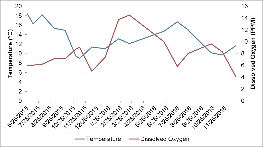 Figure 3. Water temperature and dissolved oxygen trends in San Felipe Creek, as observed during water quality surveys.
From February through August, stickleback are easily observed within San Felipe Creek by walking along the bank and looking for movement or stopping near an open portion of water (Figure 5). During the rest of the year, fish can be difficult to observe, as cold water reduces fish activity. CDFW placed three GoPro cameras on the channel invert facing upstream in summer 2016, in order to avoid altering vegetated habitat through dip net surveys. The cameras recorded for 25 minutes each while biologists hid out of sight. Video recorded by the cameras showed significantly more fish than the number observed from the bank. This method was used again in November 2016, and observed fish that were not seen through bank surveys on several occasions. This new method will be incorporated into future winter surveys to provide a less invasive monitoring technique.
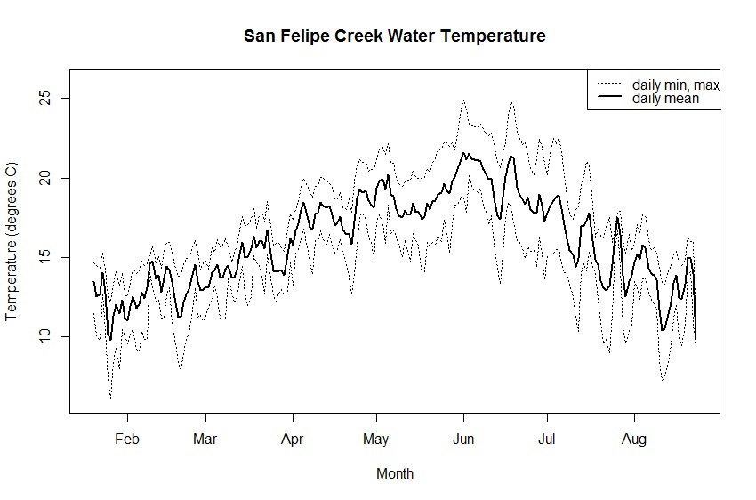 Figure 4. Average, minimum, and maximum daily temperature at San Felipe Creek from January to September 2016, as measured by continuous temperature monitoring.
Future Efforts
Although water levels, water quality, and the stickleback population appear to be stable at San Felipe Creek, monitoring efforts will continue on a monthly basis because of the importance of this population. The rescues conducted in summer 2016 within the Santa Clara River watershed highlight the need for continued monitoring of the population at San Felipe Creek. Continued drought, fire, and human impacts could result in extirpation of this genetically unique population within the Santa Clara River. If this were to happen, the San Felipe population could provide a source for repopulating the drainage with genetically similar stock.
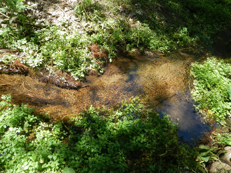 Figure 5. Stream habitat in San Felipe Creek. (CDFW photo by R. Barabe)
References
- California Department of Water Resources, 2014. Breaking Drought News. WRCC climate region dry years, ranked by inches of precipitation.
- Richmond, J. Q., D. K. Jacobs, A. R. Backlin, C. C. Swift, C. Dellith, and R. N. Fisher. 2014. Ephemeral stream reaches preserve the evolutionary and distributional history of threespine stickleback in the Santa Clara and Ventura River water sheds of southern California. Conservation Genetics.
- Swift, Camm et. al. 1993. The Status and Distribution of Freshwater Fish in Southern California. Bull. Southern California Academy of Science, 92(3), pp. 101-167.
CDFW