Mark West Creek, Sonoma County
2016 Update
Species / Location
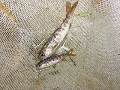 Figure 1. Juvenile Coho Salmon rescued from Willow Creek during summer 2015, a lower tributary of the Russian River. (CDFW photo M. Kittel)
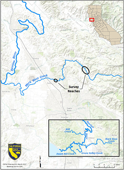
Figure 2. Map of location of survey reaches on Mark West Creek, Sonoma County. (click/tap to enlarge)
The Mark West Creek watershed is an important sub-basin which drains from approximately forty square miles of land into the Russian River. Mark West Creek supports state and federally protected aquatic species, including Coho Salmon (Oncorhynchus kisutch) and steelhead (Oncorhynchus mykiss) (Figure 1). The creek originates in the Mayacamas Mountains and flows through Sonoma County into the Laguna de Santa Rosa about five miles upstream of the Laguna’s confluence with the Russian River. The lower part of the watershed is highly urbanized and contains the Larkfield-Wikiup and Riebli-Wallace neighborhoods east of Highway 101. The creek continues west of Highway 101, where the landscape is characterized by vineyards, rangelands, and rural residential areas. Land use is similar in the upper watershed, which is mountainous and dotted with rural residential properties. Ninety-four percent of the land in the watershed is privately owned (Sonoma RCD 2015).
Need for Drought Stressor Monitoring
A dominant theme emerged from three years of drought stressor monitoring in the Russian River watershed: the survival and successful rearing of juvenile salmon and steelhead depends on maintaining summer flows. Thus, monitoring efforts focused on assessing summer flow criteria for juvenile salmon and steelhead in specific streams that support Coho Salmon. Mark West Creek is one of four Russian River tributaries that have historically maintained perennial flow during dry years. Monitoring of Coho Salmon populations has shown that these tributaries play an important role in providing critical habitat for rearing juveniles. Mark West Creek’s proximity to urban and agricultural development also makes it ecologically sensitive. The banks are highly eroded in some areas, and the impacts of heavy foot traffic and recreational activities on the lower reaches can be clearly observed.
Stressor Monitoring Efforts
In Summer 2016, two reaches (a reach is a “selected length of a stream or river”) were selected on Mark West Creek for monitoring (Figure 2). The lower reach is located in the Larkfield-Wikiup neighborhood and the upper reach is near Calistoga Rd and Alpine Rd (Figure 3). California Department of Fish and Wildlife (CDFW) surveyed these reaches once a week between late spring and fall, observing the progression of drying and rewetting throughout the season. Stream flow, water depth, water temperature, and dissolved oxygen were measured at selected riffles (a riffle is “a shallow section of a stream where the current is swift and the water surface is broken by gravel or stones”) throughout these reaches. In addition, CDFW deployed data loggers in select locations to monitor water levels and water quality around the clock. These measurements of habitat conditions were then coupled with biological data from the University of California San Diego Cooperative Extension, which conducts adult and juvenile salmon and steelhead sampling consistent with the California Coastal Salmonid Population Monitoring Plan (Adams et. al. 2011).
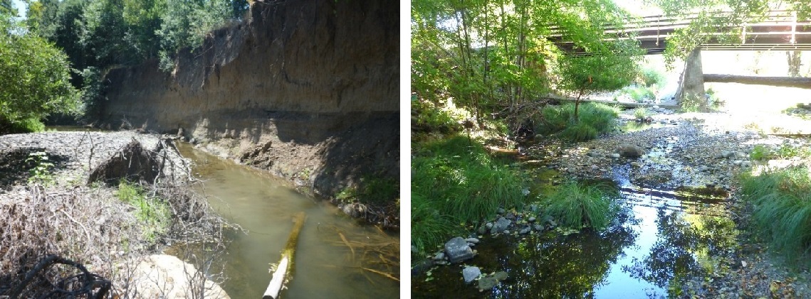 Figure 3. Pool on the lower reach of Mark West Creek during low flows with steep, eroded banks (left), and a riffle on the upper reach of Mark West Creek during low flows (right). (CDFW photo A. Persau).
Findings
Stream flow on Mark West Creek was extremely low between August and September, although surface flow was mostly maintained throughout summer 2016 (Figure 4). The lower reach had a minimum flow of 0.02 cubic feet per second (cfs), and minimum flow on the upper reach was 0.04 cfs. In both cases, the reach only became disconnected at one riffle for a short period of time before rewetting.
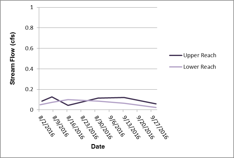 Figure 4. Spot measurements of flow in cubic feet per second (cfs) during summer 2016. Before the rains, flows were under 0.2 cfs, which can be expected in summer months. When rains came in late October, flows recovered to normal winter levels, at hundreds of cfs.
CDFW observed many differences in habitat conditions between the lower reach and upper reach. The lower reach is in a densely developed area and has highly eroded banks, while the upper reach is located in a rural residential area that sees slight bank erosion and less impacts overall. The lower reach had higher average water temperatures and lower average dissolved oxygen levels than the upper reach (Figures 5 and 6).
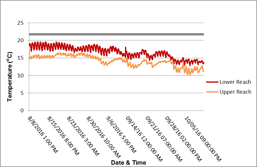 Figure 5. Observed water temperatures for Mark West Creek during summer 2016. Salmon and steelhead, especially rearing juveniles, require cold water temperatures. According to the State Water Resources Control Board, 22-24⁰C temperatures will eliminate salmon and steelhead from an area. Both reaches are safely under this limit, though the lower reach is warmer on average. This is likely due to the lack of vegetation and cliff-like banks in some areas, which expose the water to sunlight.
These conditions make the lower reach a less hospitable environment for salmon and steelhead, which become stressed if waters are too warm or oxygen levels are too low. Dissolved oxygen levels on the upper reach generally stayed above 7 mg/L—which the State Water Resources Control Board considers the minimum level for supporting healthy salmon and steelhead populations (CWT 2004)—while dissolved oxygen concentrations on the lower reach were generally below this level. Salmon and steelhead populations for 2016 reported by the University of California San Diego Cooperative Extension show moderate numbers of steelhead and relatively low numbers of Coho Salmon in Mark West Creek. In Mark West Creek and two of its tributaries, snorkelers observed 1,483 juvenile steelhead but only 8 juvenile Coho Salmon (CSG 2016). The low numbers of Coho Salmon may in part be tied to University of California San Diego Cooperative Extension staff observing an overall decline in returns of adult Coho Salmon over the past three years in the Russian River watershed as a result of the drought.
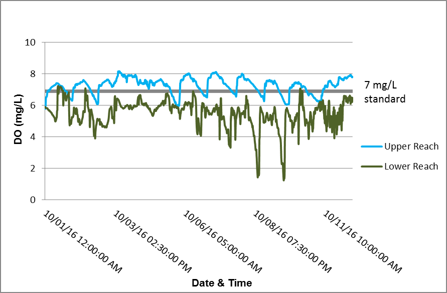 Figure 6. Observed dissolved oxygen levels for Mark West Creek during summer 2016. Dissolved oxygen on the upper reach was usually above 7 mg/L, the State Water Resources Control Board standard for supporting salmon and steelhead populations. Dissolved oxygen on the lower reach measured below this level, making the lower reach a less hospitable environment for salmon and steelhead.
Future Efforts
Goals for continuing these drought monitoring efforts include improving protocols and working cohesively with partner agencies to cover a larger area and gather as much data as possible. The University of California San Diego Cooperative Extension California Sea Grant program and the State Water Resources Control Board were invaluable partners in this year’s monitoring efforts and these collaborations will continue next summer. CDFW has also worked collaboratively with local landowners to develop voluntary drought agreements. In previous years, CDFW has participated in and organized multiple outreach meetings to make landowners aware of the effects their actions may have on water resources and wildlife. Outreach efforts should continue in the future and focus on educating landowners about their rights and responsibilities as they pertain to wells and stream diversions.
References
- Adams, et.al. 2011. California Department of Fish and Wildlife. Fish Bulletin 180, California Coastal Salmonid Population Monitoring: Strategy, Design and Methods.
- Clean Water Team (CWT) 2004. Dissolved Oxygen Fact Sheet, FS-3.1.1.0(DO). The Clean Water Team Guidance Compendium for Watershed Monitoring and Assessment, Version 2.0. Division of Water Quality, California State Water Resources Control Board (SWRCB), Sacramento, CA.
- Sonoma County Resource Conservation District (Sonoma RCD) 2015. Mark West.