(Russian River Tributaries, Sonoma County)
Species / Location
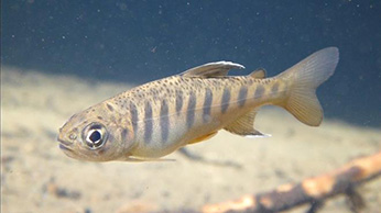 Figure 1. Juvenile Coho Salmon. CDFW photo Derek Acomb.
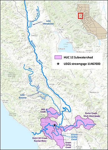 Figure 2. Map of the Russian River watershed and the four key watersheds that drought conservation measures were focused on during 2014-15. (click/tap to enlarge)
Historically, four key tributaries in the Russian River watershed have been important for coho salmon persistence and integral for the coho salmon recovery efforts: Green Valley; Dutch Bill; Mill; and Mark West creeks (Figures 1 & 2). Green Valley Creek is located in Western Sonoma County between the communities of Forestville and Occidental. Dutch Bill Creek flows from Occidental to Monte Rio. Mill Creek is a tributary to Dry Creek, located west of the City of Healdsburg. Mark West Creek is located north of Santa Rosa.
Need for Drought Stressor Monitoring
In 2014, the California Department of Fish and Wildlife (CDFW) coordinated with NMFS to evaluate minimum flow conditions for juvenile coho salmon and steelhead in these four priority reaches of the Russian River watershed considered to be at greatest risk of fisheries impairment. The goal was to determine subsistence flows, which is defined as the amount of flow needed to maintain minimal hydraulic connectivity to support habitat conditions (temperature, dissolved oxygen) needed to provide a reasonable probability of survival of steelhead and coho salmon juveniles during the summer low flow period. To determine these flows, CDFW used a site-specific, rapid flow/habitat assessment technique using a modified Critical Riffle Survey and stream discharge. CDFW and NMFS developed the rationale to inform current and future State Water Resources Control Board (SWRCB) emergency regulations for specific fisheries and for SWRCB’s general drought planning processes.
Stressor Monitoring Efforts
In June 2015, CDFW launched a wet/dry mapping effort on the four tributaries considered critical to the recovery of coho salmon in the Russian River. This work complemented similar work underway by University of California Extension and Sea Grant, and it consisted of measuring the extent of wetted habitat once a month from June until winter rains reestablished a wetted and connected stream. The recent drought provided a unique opportunity to not only measure the extent of wetted habitat at the point of lowest flow, but to also investigate how wetted habitat transitions from fully wetted and flowing to its driest condition, then back to wetted and flowing within one season (Figure 3). Figure 4 depicts the study reach and extent of wetted habitat measured along the vital salmonid spawning and rearing reaches of Green Valley Creek from June through December 2015. Subsequent monitoring indicates that flow releases provided enhanced flows in select areas sufficient to support coho salmon juveniles until fall rains appeared in October. Additionally, these frequent wet-dry mapping efforts helped inform fish rescue and relocation efforts in 2015 by confirming that salmonids were in peril from drying back riffles and pools. This provided for timely rescue and relocation efforts.
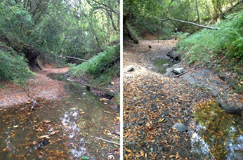 Figure 3. A before and after shot of a reach of Green Valley Creek, Russian River watershed Sonoma County that dried back during summer 2015. (click/tap to enlarge)
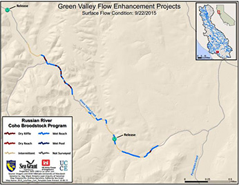 Figure 4. Lower Green Valley Creek where CDFW was allowed landowner access to wet/dry map the stream during summer 2015. (click/tap to enlarge)
In May 2015, CDFW recommended that SWRCB consider implementation of emergency regulations to protect summer flows needed to support juvenile salmonids for all areas within Green Valley, Mill, Dutch Bill, and Mark West Creek watersheds for two reasons: (1) to issue an informational order to determine the extent of current diversion operations in each watershed; and, (2) to immediately implement conservation measures to limit the amount of water extracted from these watersheds during the 2015 drought that track conservation measures the SWRCB has required elsewhere. The extent of wetted instream habitat at the driest point of the season is often not known. Of primary importance to endangered coho salmon is whether the instream habitat they depend upon is wet or dry. Annually since 2012, the University of California Extension and Sea Grant monitoring efforts have measured the wetted extent of selected coho salmon streams in the Russian River Basin at the driest point of the season in September. These previous efforts have been modeled after wet-dry mapping efforts along the San Pedro River in Mexico and Arizona, by The Nature Conservancy (Turner 2011).
Findings
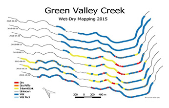 Figure 5. Map of wet-dry reaches on Green Valley Creek from June 02 through December 01, 2015.(click/tap to enlarge)
Wet-dry surveys were conducted on Green Valley Creek, Dutch Bill Creek, Mill Creek and Mark West Creek, all in Sonoma County. Figure 5 depicts the study reach and extent of wetted habitat measured along the vital salmonid spawning and rearing reaches of Green Valley Creek from June through December 2015. For the four study streams it was not possible to survey the entire stream, especially at Green Valley and Mark West creeks, due to lack of access permission provided by a number of landowners.
Future Efforts
These wet-dry mapping efforts will be studied with past and future mapping efforts to try to identify reaches that were last impacted by the drought. These late drying reaches could then be considered for focused outreach and water conservation initiatives to help maintain and perhaps enhance instream flows to benefit endangered coho salmon.
References
- Turner, D., Richter, H. (2011). Wet/Dry Mapping: Using Citizen Scientists to Monitor the Extent of Perennial Surface Flow in Dryland Regions. Environmental Management, 47, 497-505.
CDFW
California Sea Grant and University of California Extension