Species and Location
Oncorhynchus mykiss are a salmonid species inhabiting coastal streams from Alaska to Baja California. O. mykiss exhibit two life history forms: resident Rainbow Trout which live their entire lives in freshwater streams and anadromous steelhead which migrate to the ocean and return to freshwater to spawn. When populations are no longer able to access the ocean, studies have shown that anadromous genetics can persist in resident populations. Due to anthropogenically-driven declines in O. mykiss populations, Southern California steelhead are a federally listed endangered species and a candidate for California state listing.
Southern California steelhead have historically occupied most of the Ventura River watershed, including large annual winter steelhead runs (estimated between 3000-6000 individuals per year in the mid-1900s). A 1996 estimate of less than 200 steelhead in that year’s Ventura River steelhead run indicates a severe decrease in steelhead run size; estimates of more recent annual returns are in the single digits. Following drought, fire, and human impacts, the population within the watershed is a fraction of its historic numbers. As of summer 2021, only three individuals were observed in anadromous sections of the Ventura River, and two small populations survive within the Matilija Basin.
Historically, anadromous habitat in the Ventura watershed included Matilija Creek and its tributaries. Following construction of the Matilija Dam in 1947, only 0.5 miles of habitat remain accessible from the ocean while over 15 miles of habitat upstream are cut off. Isolated population of O. mykiss remain in the Matilija Creek basin. In addition to limiting available habitat, downstream effects of the dam may include poor water quality and lack of spawning sediment deposition in downstream habitat.
Several other native Species of Special Concern are also present in Matilija Basin streams including Arroyo Chub (Gila orcutti), Threespine Stickleback (Gasterosteus aculeatus), two-striped garter snake (Thamnophis hammondii), southern western pond turtle (Actinemys marmorata) and California red-legged frog (Rana draytonii).
Streams throughout the Ventura River watershed are routinely monitored by California Department of Fish and Wildlife (CDFW) staff. This case study focuses on the Matiljia Basin: Matilija, Upper North Fork Matilija, and Murietta Creeks (Figure 1).
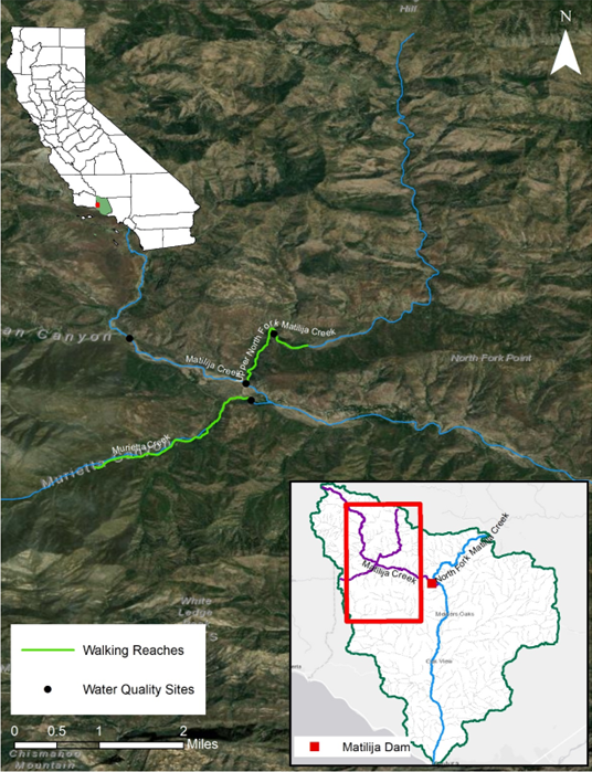 Figure 1. CDFW monitoring sites and walking reaches within the Matilija Basin. Bottom right inset shows the Ventura River watershed, with Matilija Basin streams in purple.
Need for Drought Stressor Monitoring
Based on data collected during the 2012-2019 prolonged and extreme drought, at least 3.5 of the 10.1 stream miles surveyed in the Matilija Basin dried during summer, fragmenting habitat and stranding fish. The Thomas Fire in late 2017 and early 2018 burned ninety-seven percent (approx. 32,300 acres) of the Matilija basin. Debris flows triggered by heavy rains immediately following the fire substantially modified existing stream channels and natural barriers in much of the Ventura watershed. In multiple cases (San Antonio Creek, Matilija Creek, North Fork Matilija Creek, Upper North Fork
Matilija Creek), entire creeks’
O. mykiss populations were totally or nearly extirpated. These streams are recovering but are undeniably changed in both species’ presence and habitat composition. Through regular monitoring, CDFW staff are building a better understanding of the area post-Thomas Fire: which areas dry seasonally, where fish may become stranded, and where summer refugia are located.
Stressor Monitoring Efforts
To identify drying areas and to quantify change in water quality and streamflow, CDFW drought crews conducted walking surveys of stream reaches and water quality surveys at set stations. During summer and fall, crews conducted walking surveys of select stream reaches. Habitat expected to dry or otherwise be severely drought-affected were prioritized based on data from past years. GPS units are used to record the beginning and end of wet and dry sections. Wetted extent data is processed using R and ArcGIS to create a dataset of wet and dry stream lengths from every survey conducted. This data is used to identify perennial and seasonal habitat and seasonal changes to habitat availability.
Findings
Monitoring efforts focus primarily on Upper North Fork and Murietta Creeks, both tributaries to Matilija Creek. Both creeks have historically hosted spawning O. mykiss populations. During the summer of 2021, Murietta experienced severe drying (Figure 2) with only 27% of the sample reach remaining wetted (Figure 3). By September 2021, only a few short segments remained to offer summer refugia for native fishes.
Upper North Fork Matilija Creek can sustain small O. mykiss populations. Drying on Upper North Fork Matilija was minimal where fish have been observed (0.1 mi dry of a 1.2 mi walking reach). However, water temperatures rose over 80 F, which are likely to stress fish. Long sections of Matilija Creek dried, but the areas where O. mykiss were observed remained wetted. Water quality, especially temperature, in the remaining wetted sections worsened throughout the summer before returning to better conditions with winter rains.
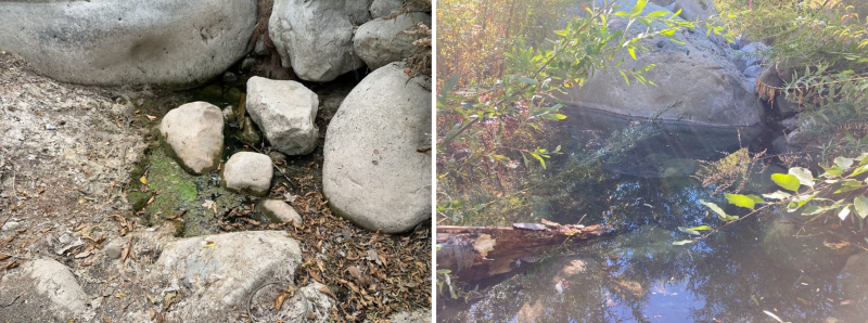 Figure 2. A unit in Murietta Creek during a fish relocation on 8/11/22 (left) and 10/26/22 (right) following a rain event. Several O. mykiss were relocated from this unit in summer 2021 and 2022.
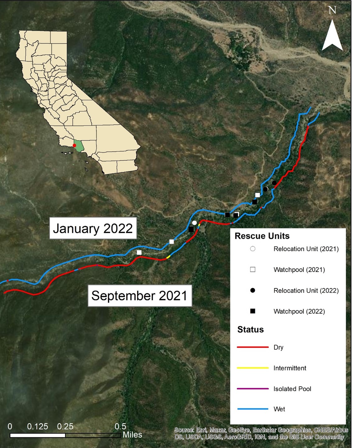 Figure 3. Wettedness map for Murietta Creek at its driest observed in 2021 (9/8/2021, lower line) and approximately two weeks after the basin received 12-13 inches of rain (1/13/2022, upper line). Rescue and relocation units from 2021 and 2022 rescues are also noted. The relocation unit located on North Fork Matilija Creek is located off the map.
Three fish rescues were conducted on Murietta Creek in the summers of 2021 (9 O. mykiss) and 2022 (25 O. mykiss) (Figure 3). By late summer 2022, overcrowding of O. mykiss in the remaining wetted habitat forced CDFW staff to look outside Murietta Creek for relocation habitat. In September 2022, 13 O. mykiss were successfully relocated from Murietta to North Fork Matilija Creek. North Fork Matilija was home to a population of O. mykiss which did not survive the debris flows of early 2018. Conditions within the creek has significantly recovered since the Thomas Fire, and once again provides excellent habitat for O. mykiss. When it became necessary to relocate O. mykiss outside of Murietta Creek, North Fork Matilija was the perfect candidate for relocation.
Future Efforts
All fish relocated to North Fork Matilija were PIT tagged upon release. CDFW maintains a PIT tag array on the Ventura River. Should any of the rescued O. mykiss attempt to migrate downstream to the ocean, they will likely be recorded passing the array. This would indicate not only a successful rescue, but the exciting possibility of O. mykiss recolonization of the Ventura River.
Walking surveys and continuous water sampling will continue in the Matilija Basin and the wider Ventura watershed, including North Fork Matilija Creek. These efforts will continue to build a dataset representing both drought and non-drought conditions and further explore the effects of drought on this area.