Cottonwood Creek, Mono County
Species / Location
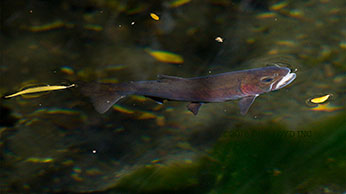
Figure 1: Paiute Cutthroat Trout in the North Fork of Cottonwood Creek. © Lloyd Chambers, all rights reserved. (click/tap to enlarge)
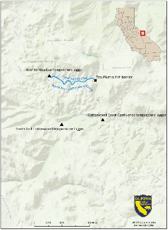 Figure 2. Map of survey reach and temperature loggers in Cottonwood Creek, Mono County. (click/tap to enlarge)
The North Fork of Cottonwood Creek is located 18 miles northeast of Bishop, California, at an elevation of approximately 9,500 feet on the eastern slope of the White Mountains. The creek supports a population of Paiute Cutthroat Trout (Oncorhynchus clarkii seleniris), a rare trout native to Silver King Creek and its tributaries in the Carson River Basin, Alpine County (Figure 1). The North Fork of Cottonwood Creek population was established in 1946 by a transplant from the Silver King Creek Basin. This population will be used to repopulate the Silver King Basin following completion of an ongoing recovery project. There are only five self-sustaining populations of Paiute Cutthroat Trout in existence (including the North Fork of Cottonwood Creek), and the species is listed as threatened under the federal Endangered Species Act due to their inability to tolerate competition from other nonnative trout species, their small population size, and their limited range.
Need for Drought Stressor Monitoring
During the last prolonged drought (1988-1991), flow declined by 85-90% relative to normal years (Kondolf 1991). Since the North Fork of Cottonwood Creek is home to a threatened trout species and is known to be susceptible to drought, the California Department of Fish and Wildlife (CDFW) increased existing monitoring of the stream in June 2015 as a part of the statewide drought monitoring program. CDFW scientists were concerned about habitat fragmentation, disease, changes in pH, and additional water quality impacts.
Stressor Monitoring Efforts
CDFW staff surveyed 1.3 miles of North Fork of Cottonwood Creek, from Granite Meadow to the lower limit of Paiute Cutthroat Trout distribution at the Tres Plumas fish barrier (Figure 2), during months when low-flows were likely to occur (June to October) in 2015 and 2016. During each survey, CDFW estimated discharge and maximum pool depth and measured dissolved oxygen concentration, water temperature, and conductivity. In addition, CDFW staff walked upstream documenting dewatered areas, counting Paiute Cutthroat Trout, and estimating sizes of observed fish. Temperature loggers were also installed at the North Fork of Cottonwood Creek in Granite Meadow and immediately above the confluence with South Fork Cottonwood to document temperature fluctuations.
Because of the underlying Precambrian and Cambrian carbonate bedrock in the surrounding watershed, the North Fork of Cottonwood Creek has an elevated pH (8.0-8.5) that may result in additional physiological stress on resident trout. Due to these concerns, pH was monitored periodically during drought surveys.
Findings
Although estimated flows were extremely low during the summers of 2015 and 2016, complete drying of portions of the stream only occurred in July 2016. Shallow water riffle habitats (<0.05 inches deep) likely prevented Paiute Cutthroat Trout from moving between refuge pools during late summer, which could have left them more vulnerable to threats such as increased predation and reduced water quality (Figure 3). The 2016 flow estimates were considerably less than previous years (Figure 4). During normal years (e.g. 1974), summer flows averaged 1.0 cfs. In historical droughts (e.g. 1991), summer flows averaged over 0.1 cfs, while in 2016, summer flows averaged 0.06 cfs. Water temperatures for 2015 and 2016 were 2°C higher on average than during the 1988-1991 drought, and showed increased daily variability (Figure 5; Table 1). However, both water temperatures and dissolved oxygen levels remained suitable for Paiute Cutthroat Trout during the monitoring period (Moyle 2002). In addition, pH remained at an elevated level of 8.0 to 8.5. Although this range is not above known tolerances of Paiute Cutthroat Trout, it is high enough to stress other trout species. Additional research could determine if elevated pH acts an additional drought stressor in this stream.
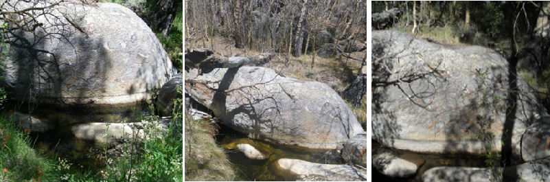 Figure 3. Reference pool in North Fork of Cottonwood Creek near Granite Meadow in July 2008 (left), May 2014 (middle), and June 2016 (right). Decreased flows often caused pool habitats to become isolated, preventing fish migration. CDFW photos.
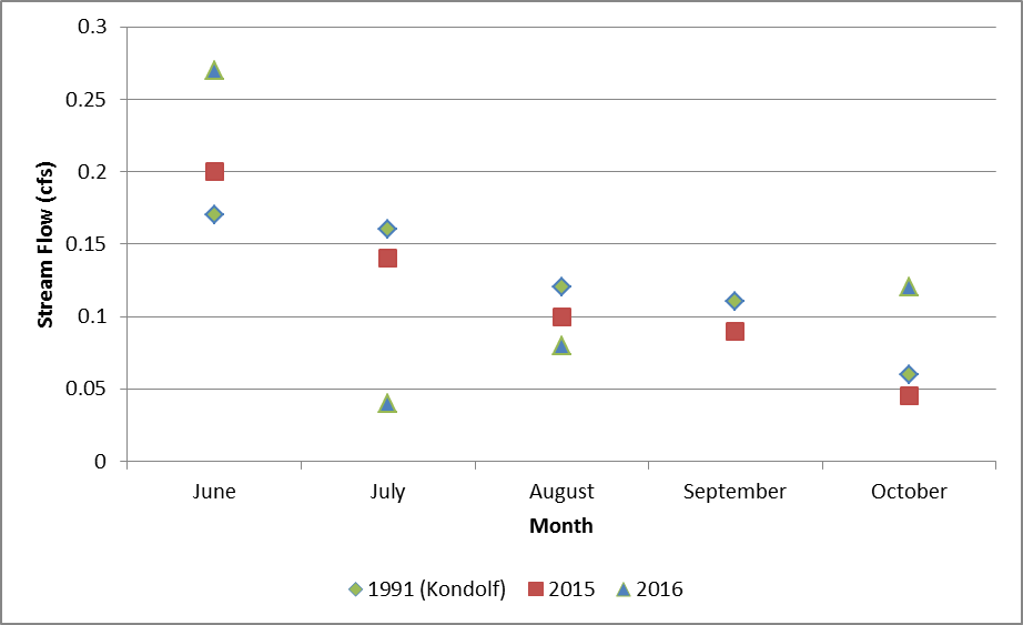 Figure 4. Comparison of 1991, 2015, and 2016 drought stream flows at Granite Meadow, in North Fork Cottonwood Creek. 1991 data are from Kondolf (1991).
CDFW surveys in 2016 found an average of 238 Paiute Cutthroat Trout, down from the historical average of 330. The number of trout observed declined during the summer survey period, likely due to mortality (Figure 6). Visual survey counts were remarkably consistent between the 2015 and 2016 surveys, and counts remained at about 70% of the historical observations. This suggests that populations may have declined due to drought.
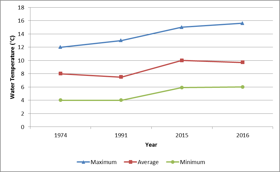 Figure 5. Comparison of historical temperature with data collected during this survey. 1974 data are from continuous-recording thermographs installed by Diana and Lane (1975), 1991 data are from Kondolf (1991).
Table 1. Data collected during 2015-2016 surveys of Cotton Wood Creek.
| Date
|
Location
|
Temperature (°C)
|
Conductivity (µS/cm)
|
Dissolved Oxygen (mg/L)
|
| 6/26/2015
|
Granite Meadow
|
14.1
|
161.2
|
7.9
|
| 6/26/2015
|
Tres Plumas Barrier
|
14.3
|
146.3
|
7.3
|
| 6/26/2015
|
Confluence
|
14.7
|
151
|
7.2
|
| 7/17/2015
|
Granite Meadow
|
14
|
174.1
|
7.4
|
| 7/17/2015
|
Tres Plumas Barrier
|
15.4
|
171
|
7.2
|
| 7/17/2015
|
Confluence
|
16.8
|
168.3
|
7.1
|
| 8/24/2015
|
Granite Meadow
|
13.5
|
177.6
|
7.6
|
| 8/24/2015
|
Tres Plumas Barrier
|
14.3
|
138.4
|
7.3
|
| 8/24/2015
|
Confluence
|
14.4
|
140.3
|
7.2
|
| 10/8/2015
|
Granite Meadow
|
8
|
189.1
|
8
|
| 10/8/2015
|
Tres Plumas Barrier
|
7.9
|
141
|
7.7
|
| 10/8/2015
|
Confluence
|
8
|
160
|
7.6
|
| 6/14/2016
|
Granite Meadow
|
11.1
|
0.26
|
7
|
| 6/14/2016
|
Tres Plumas Barrier
|
11.3
|
No data
|
7.4
|
| 6/14/2016
|
Confluence
|
11.7
|
No data
|
7.9
|
| 7/28/2016
|
Granite Meadow
|
14
|
0.02
|
No data
|
| 7/28/2016
|
Confluence
|
11
|
0.05
|
No data
|
| 8/16/2016
|
Granite Meadow
|
11
|
0.04
|
No data
|
| 8/29/2016
|
Granite Meadow
|
11.4
|
0.04
|
8.76
|
| 8/29/2016
|
Tres Plumas Barrier
|
10.5
|
0.06
|
8
|
| 10/12/2016
|
Granite Meadow
|
6.1
|
0.17
|
9.8
|
Paiute Cutthroat Trout may acquire abrasions from moving within reaches of low flows and/or elevated pH, increasing susceptibility to fungal infection by Saprolegnia, a persistent outbreak risk in the North Fork of Cottonwood Creek (Wong 1975). In 2016, four surrogate Brook Trout from immediately downstream of the refuge and one Paiute Cutthroat Trout were collected for pathological examination. Initial results indicate that biological pathogens are absent. Eight visibly diseased Paiute Cutthroat Trout were observed during the spawning period (June 2016), and two diseased Paiute Cutthroat Trout were observed in post spawn surveys.
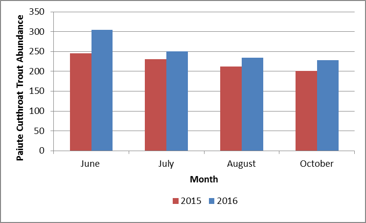 Figure 6. Monthly visual survey counts of Paiute Cutthroat Trout from the index reach of North Fork Cottonwood Creek.
Future Efforts
CDFW, in partnership with staff from the US Fish and Wildlife Service, Humboldt Toiyabe National Forest, and Inyo National Forest, is taking steps to relocate a portion of the Paiute Cutthroat Trout from the North Fork of Cottonwood Creek to the Silver King Basin, where flows are higher. In 2017, CDFW will reinstall temperature loggers. Future monitoring should include monthly visual surveys and electrofishing surveys to assess recruitment and population status, as well as spawning gravel surveys to determine the location and condition of potential spawning habitat. Gravel augmentation, or a similar management action, may be considered if it appears that suitable gravels are not present or are covered in fine sediments.
References
-
Diana, J. and Lane, E. 1975. The Movement and Distribution of Paiute Cutthroat Trout, Salmo clarkii seleniris, in Cottonwood Creek, California. Masters of Science Thesis. Department of Biology, California State University, Long Beach, California.
- Kondolf, M. 1991. Drought-year observations of Base flow in Cottonwood Basin, White Mountains, California.
- Moyle, P.B. 2002. Inland fishes of California. University of California Press.
- Wong, D. 1975. Aspects of the life history of the Paiute Cutthroat Trout, Salmo clarki seleniris (Snyder), in North Fork Cottonwood Creek, Mono County, California, with notes in a stream aquarium. Masters Thesis. Department of Biology, California State University, Long Beach, California.