Overview
The terrestrial wildlife barrier dataset represents CDFW's ongoing effort to identify wildlife movement barriers across the state.
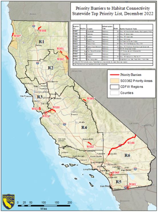
Wildlife habitat connectivity is understood to be an important mechanism of maintaining biodiversity in the face of human population growth and climate change. Listing priority wildlife barrier locations helps focus limited resources where the highest needs have been identified to improve wildlife movement. The terrestrial wildlife barrier priorities are complementary to CDFW's fish passage barrier priorities that have been identified for anadromous fish. These barrier priorities are periodically updated to reflect new information and barrier removal successes. Additional information and tools for exploring the fish Passage Assessment Database (PAD) are available through the CDFW data portal.
History of the Barrier Dataset
In 2020, Conservation Analysis Unit (CAU) staff coordinated with regional staff to develop the first version of the barrier dataset. Staff in each of the six terrestrial CDFW administrative regions identified linear segments of infrastructure that presented barriers to wildlife populations in their jurisdictions. Regional staff used all available data, including connectivity and road crossing studies, collared-animal movement data, roadkill observations, and professional expertise.
In 2022, CAU and Regional staff updated the dataset, collecting additional information on each segment, adding numerous segments, adopting a tiered prioritization structure, and reassessing the overall prioritization of barriers throughout the state.
In 2024, CAU and Regional staff were joined by staff from CDFW’s newly established Wildlife Branch Connectivity Program to conduct the second major update of the barrier dataset. Most of the barriers identified are highway segments, but other infrastructure types such as railways, high-speed rail alignments, canals, local roads, and fencing are also represented.
The Current Barrier Dataset
Following the 2024-2025 update, the Wildlife Branch assumed primary responsibility for maintaining the dataset. Visit Terrestrial Wildlife Connectivity Barriers page for the most current information on the dataset, including an interactive web map, Regional and barrier-specific summary documents, and story maps.
Reports