Science Spotlight

Subscribe

Receive Science Institute news by email.

    All Science Spotlight Articles

    rss
    Scientist, Michael Mammola holding a fish on a lake with blue sky

    Michael Mamola, CDFW’s Statewide Trout Management and Stocking Coordinator, shows off a Lahontan cutthroat trout before its release into Echo Lake earlier this spring.

    hand holding a fish for release in a lake
    The Lahontan cutthroat trout is the largest inland trout species in the world and the only trout native to the Lake Tahoe Basin.

    Visitor fishing off the side of a pier in a lake
    Few visitors to Echo Lake pause to fish and probe the waters for the Lahontan cutthroat trout that live within.

    fish in a lake
    Lahontan cutthroat trout grow large in Echo Lake, El Dorado County, thanks to the large population of forage fish, principally the Lahontan redside minnow.

    California anglers looking to target the native but elusive Lahontan cutthroat trout may want to put Echo Lake in El Dorado County on their summer itinerary.

    For the past several years, the California Department of Fish and Wildlife (CDFW) has managed the deep blue waters of Echo Lake exclusively as a Lahontan cutthroat trout sport fishery.

    That’s the same fish that has turned Nevada’s Pyramid Lake and its monster-sized cutthroats into a global fishing destination and created a cult following at Heenan Lake in Alpine County among fly anglers looking to tangle with a trophy cutthroat.

    Located just minutes off U.S. Highway 50 near South Lake Tahoe at an elevation of 7,500 feet, Echo Lake may offer California anglers their best chance to encounter the Tahoe Basin’s native trout species given the combination of an easy drive, a plentiful fish population supported through a generous stocking regimen, and wide-open fishing access without the restrictions on seasons, take or tackle methods found at some other Lahontan cutthroat trout fisheries.

    Adding to the overall experience, Echo Lake receives relatively little fishing pressure. The 300-acre lake is best known as a jumping-off point for the southern portion of Desolation Wilderness. Few of those backcountry travelers, however, pause to wet a line at Echo Lake.

    “It’s sort of a hidden gem,” says Mitch Lockhart, CDFW’s District Fisheries Biologist for El Dorado, Placer and Nevada counties. “You’ll not be combatting for space to fish here.”

    Echo Lake received a recent stocking of 100 brood stock Lahontan cutthroat trout from nearby Heenan Lake. Resplendent in their crimson spring spawning colors, the fish ranged in size from two to nine pounds with an average weight of two to three pounds. CDFW followed up that trophy stocking with a plant of some 20,000 “sub-catchable” Lahontan cutthroat trout in the seven- to nine-inch range.

    Echo Lake’s recent history as a Lahontan cutthroat trout fishery resulted from a collaboration between lakeside property owners and CDFW. Cabin owners were seeking improved fishing opportunities given recent cutbacks and elimination of hatchery stockings of rainbow trout, brown trout and brook trout. At the same time, CDFW fisheries biologists were looking for suitable locations to stock Lahontan cutthroat trout into their historic range in the Tahoe Basin and expose more anglers to the unique, native fish.

    Echo Lake fit the criteria. Its steep-sided granite cliffs, clean, cold deep waters are reminiscent of Independence Lake in Nevada County and Fallen Leaf Lake in El Dorado County, two historic and active Lahontan cutthroat trout fisheries.

    Echo Lake also is relatively isolated from other waters and protected from infiltration by non-native trout species. The lake holds some small, remnant populations of brook and brown trout with little opportunity for wild rainbow trout to access the lake and colonize it from surrounding waters. Displacement, hybridization and competition from non-native trout is largely what earned the Lahontan cutthroat trout listing under the federal Endangered Species Act 51 years ago and what mostly prevents large-scale recovery efforts today.

    And unlike some other high Sierra lakes where trout eke out a meager existence in near-sterile conditions, Echo Lake is rich with food in the form of the Lahontan redside, a native minnow that has proven an important forage fish responsible for Lahontan cutthroat trout growth rates of two to three inches a year in Echo Lake.

    Anglers reported catching Lahontan cutthroats to 26-inches last year with the average size being closer to 12 to 14 inches with an occasional 16-, 18- and 24-inch fish in the mix. CDFW biologists say they are seeing anecdotal evidence of natural spawning, but plan to manage Echo Lake primarily for recreational fishing and not species recovery.

    CDFW has stocked two strains of Lahontan cutthroat trout into Echo Lake, the Pilot Peak strain of Pyramid Lake fame that can reach sizes in excess of 20 pounds, and the smaller Independence/Summit Lake strain of fish from eggs collected at Heenan Lake and raised at the American River Trout Hatchery outside of Sacramento.

    A Lahontan cutthroat trout caught and documented from Echo Lake qualifies for CDFW’s Heritage Trout Challenge, which incentivizes and rewards anglers for catching six different forms of California native trout from their historic drainages.

    In addition to easy drive-to access, Echo Lake features a popular marina, boat launch and convenience store where kayaks and canoes can be rented. Private boats and other waterfcraft can be launched only after mandatory inspection and certification that they are free of aquatic invasive species.

    CDFW Creates Lahontan Cutthroat Trout Sport Fishery at Echo Lake (Video)

    CDFW Photos:

    Categories:   Science Spotlight
    bobcat on a dirt path

    Young bobcat photographed for project, San Diego County

    four scientists observing bobcat scat on a dirt path - click to enlarge in new window
    Bobcat project staff (left to right) Liam Jasperse-Sjolander, John Nettles, Rudolplh Mena, Jessica Copeland using stick in process of determining if scat came from bobcat

    bobcat trail camera on a dirt path with brush - click to enlarge in new window
    Bobcat project camera station, Inyo County

    bobcat in the snow with brush - click to enlarge in new window
    Bobcat in snow, San Diego County

    bobcat in sandy path with brush - click to enlarge in new window
    Bobcat in sandy terrain, San Diego County

    In the field of wildlife management, one of the most common and sometimes most difficult tasks is to obtain information about a particular species of animal in order to properly manage that species. The California Department of Fish and Wildlife (CDFW) was recently tasked by the State Legislature to conduct a demographic study of a particular species of animal that is known to be elusive and generally secretive, bobcats (Lynx rufus).

    Officially known as the California Statewide Bobcat Population Monitoring Project, the study is happening because of a bobcat hunting ban that took effect in 2020. Part of the legislation requires the issue be revisited in 2025, but only after CDFW conducts a statewide population assessment, which will then lead to a science-based bobcat management plan.

    Performing this study is complicated by a short timeline due to funding and personnel issues. Because the funding and the positions for those hired to conduct the study both end on June 30, 2022, the challenges of accomplishing this study become even greater. The effort began with forming the Bobcat Management Oversight Group (BOMOG), comprised of key individuals from around the state. That team includes the Deputy Director of Wildlife and Fisheries, the Chief of the Wildlife Branch, and key Regional and Program Managers. The BOMOG quickly realized that for the study to be successful, they would need to bring together a team of individuals from around the state. This resulted in the formation of the Technical Advisory Group (TAG), comprised of some of the top scientists and researchers within CDFW.

    “The two groups will ensure project staff are employing consistent field protocols and methods, so the project is a success,” said Wildlife and Fisheries Division Deputy Director Stafford Lehr. “Instead of one unit being responsible, the entire department is responsible for this project.”

    The TAG was asked to quickly (within two months) develop a study plan to guide the implementation of the study. The group not only met that deadline but also provided a draft capture plan as well as planned and initiated a pilot project to test the plan prior to its full implementation.

    “The TAG’s accomplishments in this very short timeline are a testament to their talent and dedication,” said South Coast Regional Wildlife Program Manager and TAG project lead Rick Mayfield. “This project would not have been possible without their hard work.”

    With the planning process completed, CDFW hired a team of 20 people specifically for the project. One was Senior Environmental Scientist Rachel Roberts who, as the lead over this group, faces the challenge of implementation and completion of the study by June 30, 2022. At that point, the data collection will end, and the analysis and creation of a statewide bobcat management plan will begin. This plan, due to be completed by January 2025, will cover all aspects of bobcat management, from demographic information to the effects of habitat loss, wildfires and urbanization on the species.

    “It’s kind of funny because we know a lot about bobcats and nothing at the same time,” said Roberts.  “We see them in a lot of places and we think that they tend to do well on the edges of urban areas. There have been projects across that state that have collared bobcats, so we have some idea of a home range, but we don’t know specifically all of the different habitats they’re residing in. We have anecdotes of them in orchards, or at high elevations, but that’s one study in one area. This project is trying to get truly to where bobcats are and where they aren’t.”

    A few things we do know about bobcats in California: they’re about one fourth the size of a mountain lion, weighing between 12 and 25 pounds depending on environmental conditions. They prey on rabbits, rodents, birds, insects, reptiles and occasionally chickens. Their current population is estimated between 70,000-100,000 statewide. Pelage (fur) markings on their body, legs and face make it possible to distinguish one from another.

    To get the most accurate information on California’s bobcat population, Roberts and her team will collect scat samples for fecal DNA analysis. This analysis allows for the individual identification necessary for determining population size via a capture/recapture model. Complementing the scat analysis in assessing the bobcat population, the teams will gather data and photographs in 48 different study areas. Each study area will be 40 square kilometers (just over 15 square miles) and have 80 cameras mounted to record still images of anything that moves in that area, day and night. The motion-activated cameras will shoot images in each study area for six weeks, before being relocated to the next study area.

    “We're taking a three-shot, rapid-fire burst with two cameras facing each other at each camera station,” said Roberts. “We're hoping to be able to get photos of the pelage patterns on each bobcat, especially on the insides of their legs – that’s how you can really identify individuals. We're hoping to see these cats more than once so that we may be able to run the capture/recapture model to estimate bobcat density with the camera data as a complement to the scat data.”

    “To get their densities and to be able to keep track of individual bobcats, so we know we’re not double-counting them, the DNA in scat is definitely the gold standard,” said Brett Furnas, a biostatistician with the CDFW Wildlife Investigations Lab. “If it’s not a bobcat sample we’re collecting it might be a coyote instead. We confirm that with genetic analysis to make sure what we’re counting is indeed from a bobcat, so we can determine individuals to count them.” Furnas is no stranger to this kind of work. “I’ve worked a lot on deer, so this method of going around and picking up bobcat scat is what we first applied to deer,’ he said. “I’ve also been working with Justin Dellinger (lead of CDFW’s mountain lion monitoring project), so this is the third project in which we’re using genetic information.”

    There’s one key difference between the gathering of scat DNA and taking of photographs. Project team members will control how much scat they gather and submit for DNA analysis. Team members won’t have control of the amount of photos that are taken by the nearly 500 hundred motion-activated cameras scattered around the state. The number of photographs to sort through and categorize would be overwhelming, if not for a new company, Wildlife Insights, which stores the images and identifies the animals photographed in the study area.

    “All of those photos are uploaded to the cloud and when you open the interface, it has already tagged the animals,” said Roberts. “If it sees turkeys, it has already tagged it. We’re just going in and making sure it’s correct. And, you can just pull out the species that you are interested in. Before, this was all super clunky. We did a pilot study and there were hundreds of thousands of photos, just from two cameras set up for eight weeks.”

    Roberts said she’ll visit most of the study areas over the course of the study, but she’d be perfectly happy making it to all 48. The challenge of measuring California’s bobcat population is exactly what she wants to be doing.

    Deputy Director Stafford Lehr sees the importance of this work for years to come. “We are striving for a more cohesive approach to applied management throughout the department and we hope this is an improved method of program delivery,” he said. “The importance of having a robust management plan that withstands scientific review and public scrutiny will pay dividends in future programs for the department.”

    CDFW Photos

    Categories:   Science Spotlight
    Bear in a tree

    A female black bear takes in her surroundings from the safety of a pine tree after being trapped, tagged and hazed by state parks and wildlife personnel last fall.

    As the Lake Tahoe Basin’s black bears emerge from their winter slow-down and slumber, campground managers, biologists, park rangers and wildlife officers hope to have a new tool at their disposal to help manage the human-bear conflicts certain to arise this spring and summer: a growing catalogue of Tahoe’s bear population.

    Since the fall of 2019, the California Department of Fish and Wildlife (CDFW) and California State Parks have teamed up to trap, tag and haze as many Tahoe bears as possible to identify individual bears, build a genetic database of the population, study its overall health, and whether related bears are passing down problem behaviors from one generation to the next. Eighteen bears have been trapped to date – four of those being recaptures. Genetic material is collected and each bear is outfitted with an identifying ear tag before release.

    This May, CDFW will broaden the effort and team up with the U.S. Forest Service to trap, tag and haze additional bears within the Tahoe National Forest. The trapping takes place in short windows during the early spring and late fall off-seasons at Tahoe-area campgrounds. The bears are hazed – but not harmed – upon release to provide a negative human interaction and to see whether the experience will keep them away from campgrounds and people in the future.

    In this video, Shelly Blair, CDFW’s wildlife biologist for El Dorado and Alpine counties, and Sarinah Simons, California State Parks Sierra District human-bear management specialist, explain the innovative collaboration and scientific work during trapping efforts last fall.

    ###

    CDFW Photo

    Categories:   Science Spotlight
    tractor plowing a field preparing the field to plant

    A three-acre field is planted with a combination of sunflower and safflower seeds to provide food for mourning doves – and a place for dove hunters to hunt come Sept. 1.

    Scientist Brian Young sitting in the back of a truck with seeds
    Oroville Wildlife Area Manager AJ Dill sits on the back of a flatbed truck stacked with sacks of safflower and sunflower seed and fertilizer for the spring planting season.

    Scientist Brian Young holding soil in a field
    Fish and Wildlife Technician Brian Young holds handfuls of safflower and sunflower seeds prior to planting.

    Field of safflower and sunflower seeds
    Upland habitat planted in the fall is lush and colorful in the spring providing important nesting habitat for wild mallards and Canada geese near the shores of the Thermalito Afterbay.

    It only took Brian Young about two laps around the freshly plowed, three-acre field before the red-winged blackbirds started showing up.

    A fish and wildlife technician at the Oroville Wildlife Area in Butte County, Young was piloting a John Deere 5075M utility tractor along the shores of the Thermalito Afterbay in mid-April, scattering a mix of sunflower and safflower seeds behind him. The red-winged blackbirds were taking full advantage of the easy meal.

    Once seeded, Young would retrace his route, distribute fertilizer and hope for the best. A quarter-mile away along a gently sloping hillside another John Deere tractor was at work covering up with soil another plowed, seeded and fertilized field.

    Spring is planting season at the 12,000-acre Oroville Wildlife Area and at dozens of other California Department of Fish and Wildlife (CDFW) properties up and down the state as crop fields are prepared for mourning doves – and the dove hunting season that begins in September. And while planted to attract doves and provide public land dove hunting opportunities, the crop fields also will provide food and habitat for all manner of wildlife, including those red-winged blackbirds.

    “Native songbirds, tricolored blackbirds, wild turkeys – you name it. Just about anything that flies – with the exception of our raptors – will be out here feeding in these fields throughout the fall,” explained AJ Dill, the Oroville Wildlife Area manager since 2013.

    Safflower and sunflower are mourning dove favorites. A couple weeks before the Sept. 1 dove season opener, the Oroville Wildlife Area’s tractors will be back to knock down the safflower and sunflower stalks and scatter the seeds to the ground where doves can access them more easily.

    Mourning doves are especially attracted to harvested agricultural fields and the food plots at Oroville and other CDFW properties can provide fast action for public land dove hunters on opening day and places to hunt throughout the season. At Oroville, however, hunters have to do their homework. Unlike some other wildlife areas, Oroville does not provide hunting maps or directions to its dove fields. Hunters have to scout and find them on their own. A Type C wildlife area, Oroville is open daily to dove hunting during California’s two dove seasons. No special permits, reservations or fees are required provided hunters are otherwise properly licensed.

    This spring, the Oroville Wildlife Area will plant about 60 acres of safflower and sunflower among 16 different fields varying in size throughout the wildlife area. The dove fields are spaced out to spread out the hunters, prevent overcrowding and foster safer hunting conditions.

    How productive the fields ultimately become will depend on many factors – but none more so than weather.

    “Everything we do out here is dryland farming. We don’t irrigate. So we really need a shot of water – just a little bit of rain – to get things going,” Dill said.

    A significant portion of the Oroville Wildlife Area’s upland habitat work also takes place in the fall when 80 acres of nesting cover are planted annually – typically some combination of vetch, barley, peas, wheat, oats, clover and grasses – along the shores of the Thermalito Afterbay to benefit nesting ducks and geese in the spring. The wildlife area maintains about 240 managed acres of upland nesting habitat in total, the dense cover providing nesting hens, their eggs and newborns safety and protection from predators.

    As with the planted dove fields, the lush, colorful, nesting habitat provides secondary benefits to other grasslands-dependent species, particularly pollinators such as bumblebees, honeybees and butterflies. The loss of grassland and upland habitat throughout California has contributed to the decline of wild mallards, wild pheasants, pollinators and other species and adds a sense of urgency and heightened importance to the upland habitat work at the Oroville Wildlife Area and other CDFW properties throughout the year.

    ###

    CDFW Photos

    Categories:   Science Spotlight
    Buena Vista Lagoon surrounded by dry grass with blue sky

    Buena Vista Lagoon Ecological Reserve, San Diego County

    Mouth of the Buena Vista Lagoon bordered by rocks and cloudy sky
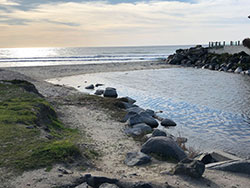
    Mouth of Buena Vista Lagoon

    Buena Vista Lagoon weir bordered by a wooden wall and trees
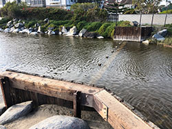
    Weir near the mouth of Buena Vista Lagoon

    cat tails weeds in Buena Vista Lagoon
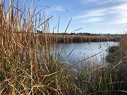
    Cattails growing on edge of lagoon

    Buena Vista Lagoon sign #Free The Lagoon Saltwater Heals Naturally
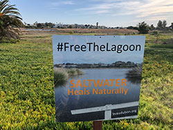
    Sign encouraging the reopening of lagoon

    The Buena Vista Lagoon Ecological Reserve in San Diego County sits between the cities of Oceanside to the north and Carlsbad to the south. It’s historic because it was the state’s first-ever reserve, created in 1968. Recently it has become considered noteworthy, if not historic, for another reason. Homeowners in that area, the San Diego Association of Governments (SANDAG), CDFW and several other groups came to an agreement after years of dispute on how the lagoon should be altered so it thrives well into the future.

    “It’s a really exciting situation, and it leads me to believe that people will do the right thing when push comes to shove and not just look out for their own personal interests,” said CDFW Reserve Manager Gabriel Penaflor.

    “To me, it's a good-news story in terms of bringing polarized stakeholders that had disparate views, together to say, we are now moving forward together,” said Planner Keith Greer of SANDAG.

    “It’s been a contentious issue for decades,” said Buena Vista Audubon Executive Director Natalie Shapiro. “It’s just wonderful that we’re all on the same page.”

    Like lagoons up and down that part of San Diego County, Buena Vista took in runoff from hills to the east and fed water to the west into the Pacific Ocean. But in the ‘40’s a weir was added at the mouth by nearby landowners, so the lagoon essentially became freshwater only. In the ‘70’s that weir was replaced with an even stronger blockage that made the lagoon even more like a lake, and not a body of water with an ocean connection.

    But what may have been a beautiful sight for residents, became an environmental, health and flooding concern for others. As the lagoon grew increasingly shallow because of increasing sediment and silt, cattails exploded in growth, taking away about 60 acres of open water over the last 30 years. Over the next 30 years the entire lagoon would more likely resemble a marsh as the open water areas as sediment continued to rise and vegetation continued to spread. Fresh water and thick cattails also bring another problem.

    “There's a large mosquito breeding ground in the lagoon and a lot of that has to do with all the cattails there, so a big concern is public health,” said CDFW’s Penaflor. “The cattails are just choking out the lagoon. They’re so big and thick they stop the larvicide that the county drops from reaching the water and affecting the mosquito larva. It’s a very arduous process to remove the cattails – they come back very fast. If it’s a saltwater lagoon the cattail wouldn’t be able to thrive in a saltwater environment. So hopefully this restoration can address public health concerns with the mosquitoes as well as improve the overall environment,” he said.

    It was 2001 when CDFW started feasibility studies about restoring the lagoon to allow saltwater back into the system, but that process would prove to be anything but a simple fix. Because the weir is on private property, those property owners would have to be part of any solution to remove the device and introduce saltwater, and early suggested improvements weren’t well received. When CDFW discussions with landowners stalled, the cities of Oceanside and Carlsbad reached out to SANDAG for assistance in getting the weir-removal project re-energized. But being involved and making progress can be two very different things.

    “It was going to be a big showdown between these two sides. One wanted saltwater, one wanted fresh water,” said Greer of SANDAG. “It was property owners versus stakeholders, and agencies versus everybody. Our board did something very smart, looking back. They stopped any kind of action on the project and said, ‘we’re going to give you guys one year, and you come back to us with a solution, or we’re going to make a decision at the SANDAG level.’ That did two things. First, it showed all the stakeholders that our board was serious and that if everyone couldn’t get on the same page, they were going to make a decision. The second, it gave the stakeholders time to reconvene and have access to our technical information to have meaningful conversations about the best thing to do. We sat with the homeowners and crafted a process moving forward. We met with wildlife agencies, and environmental groups and moved forward to allow the lagoon to get open to the ocean, while still meeting property owners needs out there.”

    Though CDFW involvement in the negotiations met with resistance early on, Regional Manager Ed Pert played a major role in the discussions roughly 15 years later.

    “He and I sat down with the owners and kind of crafted a process going forward,” said Greer. “We listened to their needs and to how we could help meet them. At the beginning, the homeowners felt like they weren't being listened to, they felt like the government was steamrolling them. I think Ed’s demeanor makes him really open to listening to people.”

    Pert is quick to deflect the credit.

    “It has been a long road in getting to the point where we can take concrete steps to restore the lagoon, and I very much appreciate the perseverance and efforts from those who made this happen,” said Pert. “Keith Greer and landowners who own the weir at the mouth of the lagoon in particular. Keith brought everyone to the table and kept us talking. Those folks deserve all the credit for finding a path forward,” he said.

    The agreement reached on what’s called the Modified Saltwater Alternative would accomplish two things. First, it would reintroduce saltwater to the lagoon through a larger channel and the removal of the weir. Second, the lagoon will maintain a freshwater feel through a dredging operation that removes more than 900,000 cubic yards of sediment. Those deeper sections of the lagoon will remain filled with seawater at low tide. The agreement also calls for significant amounts of vegetation to be removed, which will help solve the mosquito issue.

    “We're elated that the saltwater alternative has been approved, because it'll allow the lagoon to be reconnected with the ocean,” said Shapiro. “Returning the lagoon to a saltwater environment will greatly enhance the biological diversity, which will be very beneficial to bird populations. At the Audubon Society we're interested in bird habitat and currently, it's just not providing enough habitat diversity for birds. For example, there's an endangered species called the Ridgway’s rail which adapted to freshwater habitat, but it does really well with saltwater habitat. The big thing that's lacking right now are mudflats which will be created once there are tidal flows and that's important for shorebirds, like the Snowy Plover.”

    Because this was never going to be a simple fix, huge hurdles remain before Buena Vista Lagoon is once again salty. While preliminary engineering is complete, state and federal permits must be obtained, and 5 million dollars is needed to make the project bid ready for construction. The final step is the highest of those hurdles; locating the 80 million dollars it will take for actual construction. Because SANDAG has recently restored another San Diego-area lagoon and is preparing to start work on another, Greer is confident the money will be found through state and federal sources.

    “One year to be shovel-ready as we call it,” said Greer. “Within two years, I think we'll have a solid commitment for that 80 million dollars. Five years from now, we’ll probably be under construction.”

    All those years of discussions and negotiations that eventually led to agreements and handshakes, on a project that would scare away many, is what makes Greer happy.

    “Bringing all those groups together, that’s the fun part,” he said.

    ###

    Media Contact:
    Tim Daly, CDFW Communications, (916) 201-2958

    CDFW Photos

    Categories:   Science Spotlight