Regulations
Updated June 23, 2026.
These regulations are subject to in-season change. It is the reader's responsibility to know and abide by all regulations in effect at the time of fishing activity. Check for current regulations on this page and on the Ocean Sport Fishing interactive map prior to fishing. (Shore-based anglers and spear divers are exempt from seasons and depths2.)
See Boundary Line Descriptions for information on groundfish boundary lines.
Certain areas within the management area may further prohibit or restrict fishing 1, 3 such as:
Descending Devices Required4: No one may take or possess any federal groundfish from any boat or other floating device in ocean waters without a descending device in possession.
These Rockfishes May Not Be Taken or Possessed in California - No Retention at Any Time: Bronzespotted Rockfish (JPG), Cowcod, Quillback Rockfish, and Yelloweye Rockfish (CCR T14, §28.55). Fishing is closed year-round, at all depths, no retention at any time (zero fish per person).
Statewide Daily Bag Limits and Minimum Size Limits
Groundfish Regulations For All Anglers and Spearfishing Divers
| Species |
Daily Bag Limit3 |
Min. Size Limit5 |
Filleting Aboard a Vessel6 |
RCG Complex
includes all species of Rockfishes, Cabezon and Greenlings
(§1.91 (a)(1), 1.91(a)(3), 1.91(a)(4), 28.55, 28.28, and 28.29). |
10 fish in combination per person, except:
Copper rockfish (PDF): 1 fish per person
Vermilion/sunset rockfish (PDF):
Canary rockfish (PDF): 2 fish per person |
All Rockfish: No minimum size limit
Cabezon and Greenlings: No minimum size limit |
All Rockfish: No minimum length. Fillets must have entire skin attached
Cabezon and Greenlings: No minimum length. Fillets must have the entire skin attached |
Lingcod
(§28.27) |
2 fish per person |
22" total length |
Minimum 14" in length with the entire skin attached |
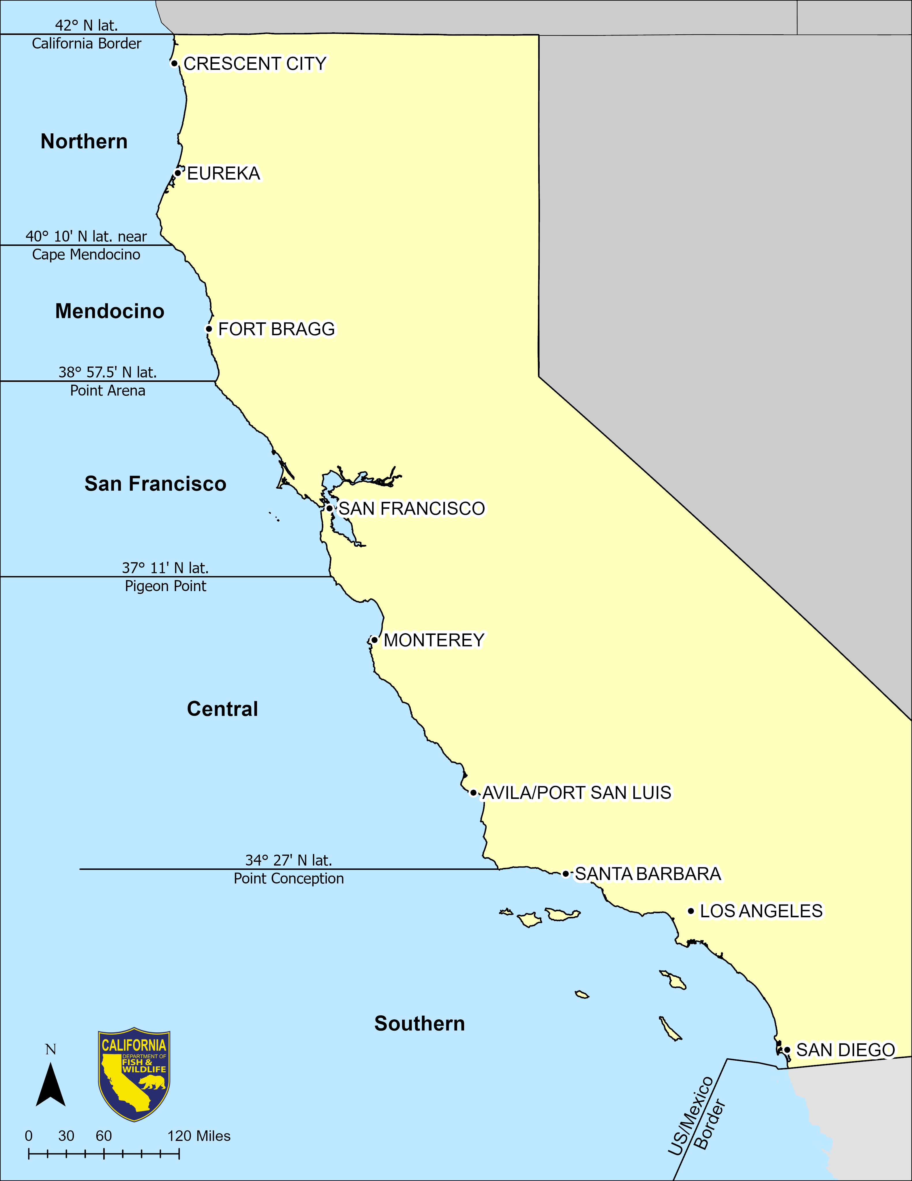
Seasons, Depth Restrictions, and Groundfish Management Areas
 (click/tap to enlarge)
Jump to
Northern Management Area Recreational Groundfish Regulations Summary 1, 2, 3
42°00’ N. latitude (CA-OR Border) to 40°10' N. latitude (near Cape Mendocino) (CCR T14, §27.25(a))
Printable PDF of this table
| Nearshore (PDF) Rockfish, Cabezon, and Greenlings |
Shelf (PDF) and Slope (PDF) Rockfish
and Lingcod |
Nearshore Rockfish (CCR T14, §1.91(a)(1): black, black and yellow, blue, brown, calico, China, copper, gopher, grass, kelp, and olive rockfishes; treefish
Cabezon and Greenlings (CCR T14, §28.28 and §28.29) |
Shelf Rockfish (CCR T14, §1.91(a)(3)): bocaccio; canary, chilipepper, dusky, flag, greenblotched, greenspotted, greenstriped, harlequin, honeycomb, Mexican, pink, redstripe, rosethorn, rosy, shortbelly, silvergray, speckled, squarespot, starry, stripetail, tiger, vermilion/sunset, widow, and yellowtail rockfishes
Slope Rockfish (CCR T14, §1.91(a)(4)): aurora, bank, blackgill, darkblotched, redbanded, rougheye, sharpchin, shortraker, splitnose, and yellowmouth rockfishes; Pacific ocean perch
Lingcod (CCR T14, §28.27) |
| Jan 1 - Mar 31: Closed - unlawful to possess in all waters |
Jan 1 - Mar 31: Closed - unlawful to possess in all waters |
| April 1 - December 31: Open all depths |
April 1 - December 31: Open all depths |
Mendocino Management Area Recreational Groundfish Regulations Summary 1, 2, 3
40°10' N. latitude (near Cape Mendocino) to 38°57.5' N. latitude (Point Arena)(CCR T14, §27.30(a))
Printable PDF of this table
| Nearshore (PDF) Rockfish, Cabezon, and Greenlings |
Shelf (PDF) and Slope (PDF) Rockfish
and Lingcod |
Nearshore Rockfish (CCR T14, §1.91(a)(1): black, black and yellow, blue, brown, calico, China, copper, gopher, grass, kelp, and olive rockfishes; treefish
Cabezon and Greenlings (CCR T14, §28.28 and §28.29) |
Shelf Rockfish (CCR T14, §1.91(a)(3)): bocaccio; canary, chilipepper, dusky, flag, greenblotched, greenspotted, greenstriped, harlequin, honeycomb, Mexican, pink, redstripe, rosethorn, rosy, shortbelly, silvergray, speckled, squarespot, starry, stripetail, tiger, vermilion/sunset, widow, and yellowtail rockfishes
Slope Rockfish (CCR T14, §1.91(a)(4)): aurora, bank, blackgill, darkblotched, redbanded, rougheye, sharpchin, shortraker, splitnose, and yellowmouth rockfishes; Pacific ocean perch
Lingcod (CCR T14, §28.27) |
| Jan 1 - Mar 31: Closed - unlawful to possess in all waters |
Jan 1 - Mar 31: Closed - unlawful to possess in all waters |
| April 1 - December 31: Open all depths |
April 1 - December 31: Open all depths |
San Francisco Management Area Recreational Groundfish Regulations Summary 1, 2, 3
38°57.5' N. latitude (Point Arena) to 37°11' N. latitude (Pigeon Point)(CCR T14, §27.35(a))
Cordell Bank: all groundfish fishing is prohibited to protect sensitive habitat. See the NMFS compliance guide (PDF) for detailed information
Printable PDF of this table
| Nearshore (PDF) Rockfish, Cabezon, and Greenlings |
Shelf (PDF) and Slope (PDF) Rockfish
and Lingcod |
Nearshore Rockfish (CCR T14, §1.91(a)(1): black, black and yellow, blue, brown, calico, China, copper, gopher, grass, kelp, and olive rockfishes; treefish
Cabezon and Greenlings (CCR T14, §28.28 and §28.29) |
Shelf Rockfish (CCR T14, §1.91(a)(3)): bocaccio; canary, chilipepper, dusky, flag, greenblotched, greenspotted, greenstriped, harlequin, honeycomb, Mexican, pink, redstripe, rosethorn, rosy, shortbelly, silvergray, speckled, squarespot, starry, stripetail, tiger, vermilion/sunset, widow, and yellowtail rockfishes
Slope Rockfish (CCR T14, §1.91(a)(4)): aurora, bank, blackgill, darkblotched, redbanded, rougheye, sharpchin, shortraker, splitnose, and yellowmouth rockfishes; Pacific ocean perch
Lingcod (CCR T14, §28.27) |
| Jan 1 - Mar 31: Closed - unlawful to possess in all waters |
Jan 1 - Mar 31: Closed - unlawful to possess in all waters |
| April 1 - December 31: Open all depths |
April 1 - December 31: Open all depths |
Central Management Area Recreational Groundfish Regulations Summary 1, 2, 3
37°11' N. latitude (Pigeon Point) to 34°27' N. latitude (Point Conception)(CCR T14, §27.40(a))
Printable PDF of this table
| Nearshore (PDF) Rockfish, Cabezon, and Greenlings |
Shelf (PDF) and Slope (PDF) Rockfish
and Lingcod |
Nearshore Rockfish (CCR T14, §1.91(a)(1): black, black and yellow, blue, brown, calico, China, copper, gopher, grass, kelp, and olive rockfishes; treefish
Cabezon and Greenlings (CCR T14, §28.28 and §28.29) |
Shelf Rockfish (CCR T14, §1.91(a)(3)): bocaccio; canary, chilipepper, dusky, flag, greenblotched, greenspotted, greenstriped, harlequin, honeycomb, Mexican, pink, redstripe, rosethorn, rosy, shortbelly, silvergray, speckled, squarespot, starry, stripetail, tiger, vermilion/sunset, widow, and yellowtail rockfishes
Slope Rockfish (CCR T14, §1.91(a)(4)): aurora, bank, blackgill, darkblotched, redbanded, rougheye, sharpchin, shortraker, splitnose, and yellowmouth rockfishes; Pacific ocean perch
Lingcod (CCR T14, §28.27) |
| Jan 1 - Mar 31: Closed - unlawful to possess in all waters |
Jan 1 - Mar 31: Closed - unlawful to possess in all waters |
| April 1 - December 31: Open all depths |
April 1 - December 31: Open all depths |
Southern Management Area Recreational Groundfish Regulations Summary 1, 2, 3
34°27' N. latitude (Point Conception) to the U.S.-Mexico Border (CCR T14, §27.45(a))
Groundfish Exclusion Areas: Eight Groundfish Exclusion Areas here restrict certain fishing activities (§27.50)
Printable PDF of this table
| Nearshore (PDF) Rockfish, Cabezon, and Greenlings |
Shelf (PDF) and Slope (PDF) Rockfish
and Lingcod |
Nearshore Rockfish (CCR T14, §1.91(a)(1): black, black and yellow, blue, brown, calico, China, copper, gopher, grass, kelp, and olive rockfishes; treefish
Cabezon and Greenlings (CCR T14, §28.28 and §28.29) |
Shelf Rockfish (CCR T14, §1.91(a)(3)): bocaccio; canary, chilipepper, dusky, flag, greenblotched, greenspotted, greenstriped, harlequin, honeycomb, Mexican, pink, redstripe, rosethorn, rosy, shortbelly, silvergray, speckled, squarespot, starry, stripetail, tiger, vermilion/sunset, widow, and yellowtail rockfishes
Slope Rockfish (CCR T14, §1.91(a)(4)): aurora, bank, blackgill, darkblotched, redbanded, rougheye, sharpchin, shortraker, splitnose, and yellowmouth rockfishes; Pacific ocean perch
Lingcod (CCR T14, §28.27) |
| Jan 1 - Mar 31: Closed - unlawful to possess in all waters |
Jan 1 - Mar 31: Closed - unlawful to possess in all waters |
| April 1 - June 30: Open All Depths |
April 1 - June 30: Open All Depths |
July 1 - Sep 30: 50 Fathom - Inshore Only
Take is prohibited seaward of the 50 fathom (300 feet) Rockfish Conservation Area boundary line, which is a series of connected waypoints defined in Federal regulations (50 CFR Part 660, Subpart C) |
July 1 - Sep 30: 50 Fathom - Inshore Only
Take is prohibited seaward of the 50 fathom (300 feet) Rockfish Conservation Area boundary line, which is a series of connected waypoints defined in Federal regulations (50 CFR Part 660, Subpart C) |
| Oct 1 - Dec 31: Closed - unlawful to possess in all waters |
Oct 1 - Dec 31: 50 Fathom - Offshore Only
Take is prohibited shoreward of the 50 fathom (300 feet) Rockfish Conservation Area boundary line, which is a series of connected waypoints defined in Federal regulations (50 CFR Part 660, Subpart C) |
Footnotes
- When angling from shore (includes beaches, banks, piers, jetties, breakwaters, docks, and other man-made structures connected to the shore), all species, except those listed in CCR T14, §28.55(b)(1), may be taken and/or possessed year-round. No vessel or watercraft (motorized or non-motorized) may be used to assist in the take, transport and/or possession of these species under this provision.
- When diving or spearfishing, as authorized in CCR T14, §28.90, all species, except those listed in CCR T14, §28.55(b)(1), may be taken and/or possessed year-round. When boat-based groundfish fishing is closed, all types of fishing gear, except spearfishing gear, are prohibited to be aboard the vessel or watercraft (motorized or non-motorized) when taking and/or possessing these species under this provision.
- It is unlawful to possess a groundfish species or species group within a Groundfish Management Area where the take and possession of those species are prohibited in all waters of that Groundfish Management Area or in excess of the bag limit of that Groundfish Management Area, regardless of if the groundfish species or species group were taken in a different Groundfish Management Area where the take or possession is authorized (§27.20(b)(1)(A)(1)).
Boundary Line Descriptions
Access the map viewer to see the 50-fathom Rockfish Conservation Area line along the mainland coast and around the Channel Islands for reference.
Coordinates delineating the Federal Rockfish Conservation Area lines and other groundfish closures can be downloaded at NOAA Fisheries' West Coast Groundfish Closed Areas page.