Vizcaino Rock Special Closure

turbulent, frothy seawater at the base of a rocky cliff

Overview

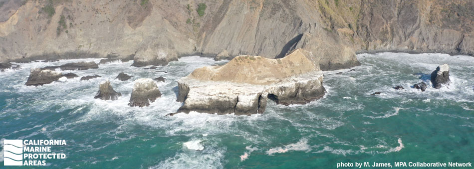
Vizcaino Rock Special Closure is located south of Double Cone Rock State Marine Conservation Area along the remote Mendocino coastline, just over 20 miles north of Fort Bragg. Surrounded by small rocky outcroppings, Vizcaino Rock is a large, rocky sea stack that sits less than a hundred feet offshore from Cape Vizcaino, at the south end of Rockport Bay. A 300-foot zone of protected waters surrounds this critical habitat, protecting seabirds and other marine life, and buffering the impacts of human disturbance.

This seasonal special closure prohibits boat traffic and human activity from March through August. Vizcaino Rock is used by nearly 8,800 breeding seabirds annually, including the Brandt’s cormorant, pigeon guillemot, and rhinoceros auklet, which nest and roost on the rocky terrain. Since access along this stretch of coast is limited, one of the only ways to catch a glimpse of Vizcaino Rock is while boating or kayaking offshore.

Regulations

March 1 to August 31 only:

Boating and access are restricted. Except as permitted by federal law or emergency caused by hazardous weather, no vessel shall be operated or anchored from the mean high tide line to a distance of 300 ft. seaward of the mean lower low tide line of any shoreline of Vizcaino Rock.

No person except employees of the California Department of Fish and Wildlife, United States Fish and Wildlife Service, National Oceanic and Atmospheric Administration, or United States Coast Guard during performance of their official duties, or unless permission is granted by the California Department of Fish and Wildlife, shall enter the area.

California Code of Regulations Title 14, Section 632(b)(18)(opens in new tab)

Quick Facts

Special Closure size: 0.02 square miles

Habitat composition*:

  • Rock: 0.06 square miles
  • Sand/mud: Less than 0.01 square miles

*Habitat calculations are based on 3-dimensional area and may exceed the total MPA area listed above.

Photo Gallery

Video Gallery

California's MPA Network

About Vizcaino Rock Special Closure

Natural History

a dark seabird takes flight from the water
Double crested cormorant takes off from the water along the Mendocino Coast. photo © rmyoshihara, CC BY-NC 2.0

Vizcaino Rock is a large sea stack that sits among smaller outcroppings scattered along the rugged northern California coastline. Many of the sea stacks along the northern California coast are derived from Franciscan mélange, a conglomeration of sandstone, shale, serpentine, and other volcanic rocks that were originally part of the oceanic plate. The rocks were uplifted as the oceanic plate collided with the North American Plate.

The rocky cliffs and jagged overhangs of Vizcaino Rock provide ideal roosting habitat for nearly 8,800 seabirds, including Brandt’s cormorant, pelagic cormorant, common murre, pigeon guillemot, and rhinoceros auklet.

Rockport Rocks is a conglomeration of offshore rocky islands located less than a mile north of Vizcaino Rock, at the northernmost point of Rockport Bay. Rockport Rocks works as a complex with Vizcaino Rock Special Closure, together supporting over 11,000 seabirds.

The adjacent shoreline is composed of black sand beaches and rocky tidepools that sit beneath steep coastal bluffs lined with redwood forests. The waters around Vizcaino Rock Special Closure support Dungeness crab, salmon, lingcod, surf smelt, and California halibut. Pacific harbor seals, California sea lions, and Steller sea lions are often found feeding offshore or basking on rocky outcroppings along the shoreline. Gray whales, humpback whales, and even the occasional pod of orcas can also be seen offshore.

Cultural History

a mass of mussels and barnacles
Mussels and gooseneck barnacles on the Mendocino Coast. CDFW photo by L. Kashiwada

For centuries, Native American Tribes in California have relied on marine and coastal resources. Many Native American Tribes in California continue to regularly harvest marine resources within their ancestral territories and maintain relationships with the coast for ongoing customary uses. The Pomo people and Coast Yuki tribe are two of the Native American groups indigenous to this northern California region.

The Coast Yuki relied on coastal resources, referring to themselves as ‘Ukoht-ontilka’, which means ‘ocean people’. Harvesting food from the ocean was very important to Native American Tribes, especially fishing for salmon during seasonal runs. Smelt, eel, and shellfish including mussels and abalone were also dietary staples. In the 1800s, when European and American settlers began arriving, native people were displaced or died from disease. Today, there are over 15 federally recognized tribes with ties to this area, including the Redwood Valley Rancheria of Pomo Indians and the Big Valley Band of Pomo Indians of the Big Valley Rancheria.

Following the arrival of Europeans, logging became the main industry along this stretch of the Mendocino coast. Beginning around 1850, mass quantities of the big redwoods that defined this coastal environment were cut down, milled, and shipped out of nearby ports. Though the last big mill was shut down in 1998, remnants of the logging industry can still be seen today in remote coastal communities.


Recreation

downward view of water crashing against steep rocks
Vizcaino Rock. photo by M. James, MPA Collaborative Network

Located far away from the hustle and bustle of cities and congested roads, Vizcaino Rock Special Closure lies adjacent to a stretch of undeveloped coastline that receives few visitors. The breathtaking landscape here consists of dramatic sea cliffs that are lined with dense redwood forests, chaparral, and grasslands.

Vizcaino Rock lies between two unincorporated Mendocino County communities: Rockport to the north and Hardy to the south. Rockport Bay Beach, adjacent to Vizcaino Rock, is a beautiful, private sandy beach that restricts general public access. This beach used to be a port for loading lumber on ships back in the late 1800s, and today is designated solely for use by the Mendocino Redwood Company. Three campgrounds are located just a couple of miles south of the special closure, at Westport-Union Landing State Beach. Fishermen can set up along the sandy beach to catch surf smelt, night smelt, and the many species of rockfish that inhabit local waters. Many photographers are drawn to the beautiful and dramatic coastal landscapes in this area that offer amazing opportunities to see wildlife, including gray whales which annually migrate from Alaska to Baja California.

Coordinates

A special closure is designated from the mean high tide line to a distance of 300 feet seaward of the mean lower low tide of any shoreline of Vizcaino Rock westward of 123o 49.887 ′ W. longitude, during the period of March 1 to August 31.

California Code of Regulations Title 14, Section 632(b)(18)

Downloads for Vizcaino Rock Special Closure

Map

Map of Vizcaino Rock Special Closure - click to enlarge in new tab

Facts, Map & Regulations

MPA fact sheet - click to enlarge in new tab