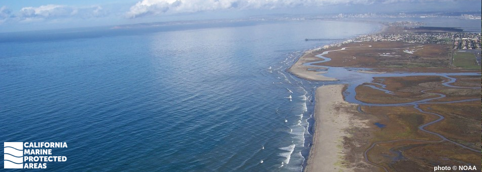
Natural History
Least tern flying through the Tijuana River Mouth SMCA with prey.
photo © hikingsandiego, CC BY-NC 2.0
Tijuana River Mouth SMCA sits at the southern edge of California, bordering Mexico, and includes a variety of unique marine and estuary ecosystems. The large sandy beaches along shore support native plants and provide nesting habitat for birds, including the endangered western snowy plover. The estuary and wetlands, where the river and ocean meet, host fish including leopard sharks, flounder, skates, and rays while also serving as nursery grounds to rockfish, halibut, and various invertebrates. Rocky reefs support California spiny lobsters, schooling sardines and anchovies, and an important spawning area for barred sand bass, a popular Southern California sport fish.
The SMCA lies adjacent to the Tijuana River National Estuary, a National Estuarine Research Reserve site and Southern California’s only coastal lagoon not divided by roads and rail lines. With more than 90 percent of Southern California wetlands destroyed by development and other land use changes, Tijuana River Estuary is one of the few intact salt marshes remaining. This area is considered an essential breeding, feeding, resting, and nesting ground for more than 370 species of migratory and resident birds. In addition to more common species like western gulls, brown pelicans, black-bellied plovers, and willets, the area hosts sensitive species such as California least terns and light-footed clapper rails, which have experienced population declines due to loss of appropriate habitat.
Cultural History
The Kumeyaay used Pismo clam shells as scoops and spoons.
photo © hikingsandiego, CC BY-NC 2.0
For centuries, Native American Tribes in California have relied on marine and coastal resources. Many Native American Tribes in California continue to regularly harvest marine resources within their ancestral territories and maintain relationships with the coast for ongoing customary uses. This culturally rich area is home to the Kumeyaay people, and members of the Kumeyaay’s southern branch, known as the Tipai, lived near the estuary seasonally and thrived on local resources.
The first European colonizers were soldiers, explorers, and missionaries. Soon after settlement, the San Diego Presidio and San Diego Mission were established in 1769. In 1848, when the Treaty of Guadalupe Hidalgo was signed, the homelands of the Kumeyaay were split, leaving part of their people on either side of the U.S.-Mexico border. In October 1849, members of a joint U.S.-Mexico International Boundary Commission met overlooking the Tijuana River Estuary to begin demarcating the United States/Mexico International Border.
By 1929, the United States Navy had acquired land around the estuary, calling its first leasehold “Border Field”, which was used as a gun range and training ground through World War II. In 1961, the Navy decommissioned Border Field, and ten years later, 372 acres were established as Border Field State Park. In 1974, the International Boundary Monument was placed on the National Register of Historic Places and the southern portion of the estuary was afforded protection. In the years following, community members came together to defeat plans for channeling the Tijuana River for use as a marina, and in 1980, the unfragmented estuary was designated the Tijuana Slough National Wildlife Refuge, which now borders the MPA established in 2012.
Recreation
Children holding kelp wrack on the beach. photo © B. Auer, CC BY-NC 2.0
Visitors can access this protected area from Seacoast Drive in Imperial Beach, just north of the SMCA, or from the Tijuana River National Estuarine Research Reserve/Border Field State Park. While the beachfront is not popular among swimmers or surfers due to hazardous conditions such as rip currents and a lack of lifeguards, there are excellent opportunities for hiking, photography, birdwatching, and horseback riding adjacent to the SMCA.
Certain recreational and commercial fishing is permitted, including take of coastal pelagic species (except market squid). Visitors can also explore Tijuana River National Estuarine Research Reserve and the Tijuana Slough National Wildlife Refuge to learn about the area’s wetland and coastal life. The southern portion of the SMCA is next to Border Field State Park, which offers amenities including picnic areas, restrooms, barbeques, horse corrals, and scenic views.
Coordinates
This area is bounded by the mean high tide line and straight lines connecting the following points in the order listed except where noted:
32° 34.000' N. lat. 117° 07.980' W. long.;
32° 34.000' N. lat. 117° 09.000' W. long.;
32° 31.970' N. lat. 117° 09.000' W. long.; thence eastward along the U.S./Mexico Border to
32° 32.064' N. lat. 117° 07.428' W. long.;
California Code of Regulations Title 14, Section 632(b)(147)