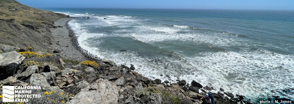
Natural History
A number of interesting species can be found in the intertidal zone of Sea Lion Gulch SMR.
photo © nmill23, CC BY-NC 2.0
The San Andreas Fault runs northwest for hundreds of miles through California before it finally heads west at Cape Mendocino in Humboldt County, less than four miles northwest of Sea Lion Gulch SMR. The San Andreas Fault defines the boundary between the western edge of the North American Plate and the Pacific Plate in California.
The movement of these tectonic plates resulted in uplift of the King Range, which runs parallel to the coast from southern Humboldt County into northern Mendocino County and is part of the much longer Northern Coast Ranges. The sharp rise of the King Range creates one of the steepest coasts in the state, a defining feature of California’s Lost Coast. The narrow wave-cut beach of Sea Lion Gulch SMR is set against the towering coastal mountains and presents a challenge to hikers who must time their trek to avoid getting trapped by high tides.
The narrow beach of the SMR is a favored haul-out site for harbor seals, Steller sea lions, and elephant seals. Seabirds roost and nest on the offshore rocks, while the onshore areas of rocky intertidal habitat are abundant with mussels, barnacles, anemones, and algae. About two-thirds of the underwater habitat is sandy, with expanses of rocky reef comprising much of the remaining area. The reef habitat provides substrate for sedentary and mobile animals, including feather stars, white-plumed anemones, octopus, and a wide variety of fish such as rockfish, lingcod, and cabezon.
Cultural History
Spend an evening at Sea Lion Gulch SMR to be among the last people in California to see the sun set.
photo © C. Allison, MPA Collaborative Network
For centuries, Native American Tribes in California have relied on marine and coastal resources. Many Native American Tribes in California continue to regularly harvest marine resources within their ancestral territories and maintain relationships with the coast for ongoing customary uses. Sea Lion Gulch SMR is located within the territory of the To-cho-be-keah Sinkyone people.
Sea Lion Gulch, located several miles south of Punta Gorda, is one of the westernmost points in the continental United States. A lighthouse was established in January 1912, accomplished with great effort due to the remote, rugged location, and lack of roads. After the Coast Guard assumed command of the lighthouse, a rough road was constructed in 1935 on the beach, but was often impassable, especially during winter months.
In 1951, the Coast Guard placed a lighted whistle buoy offshore and decommissioned the Punta Gorda Light Station. Control of the Punta Gorda Lighthouse was transferred to the Bureau of Land Management (BLM). Groups of squatters took up residence in the buildings in the 1960s, and unable to keep people from residing there, the BLM burned the wooden structures. Today, all that remains are the concrete lighthouse, oil house, and a few concrete pads where other structures once stood.
Recreation
A hike near remote Sea Lion Gulch SMR is challenging but rewarding. photo © C. Allison, MPA Collaborative Network
Travel to Sea Lion Gulch SMR is not for the faint of heart. No matter which way you approach, miles of travel along narrow winding roads followed by a lengthy beach walk are required. Those approaching the MPA by boat must launch at Shelter Cove about 20 miles to the south, or from Humboldt Bay around 40 miles to the north.
Hikers can gain access to Sea Lion Gulch SMR using the Lost Coast Trail. Mattole Beach is the northern terminus of the Lost Coast Trail, where hikers walk more than three miles along the beach to the Punta Gorda Lighthouse; the northern boundary of Sea Lion Gulch SMR is about one mile south of the lighthouse. The hike is strenuous, full of rocky outcroppings and narrow strips of beach where waves crash against the cliffs. High tides frequently trap hikers, so time your hike based on the low and receding tides. The hike offers the chance to see elephant seals, harbor seals, and Steller sea lions hauled out on shore or hunting beneath the waves. Gray whales may be spotted making their annual migration, while seabirds like the black oystercatcher, common murre, and pigeon guillemot forage in nearshore waters.
Hikers can camp at Cooskie Creek at the southern end of the SMR, however overnight use requires a permit within the King Range Wilderness Area. Remember that no take is allowed in the Sea Lion Gulch SMR.
Coordinates
This area is bounded by the mean high tide line and straight lines connecting the following points in the order listed except where noted:
40° 14.400' N. lat. 124° 19.983' W. long.;
40° 14.400' N. lat. 124° 25.943' W. long.; thence southward along the three nautical mile offshore boundary to
40° 12.800' N. lat. 124° 24.809' W. long.; and
40° 12.800' N. lat. 124° 18.155' W. long.
California Code of Regulations Title 14, Section 632(b)(14)