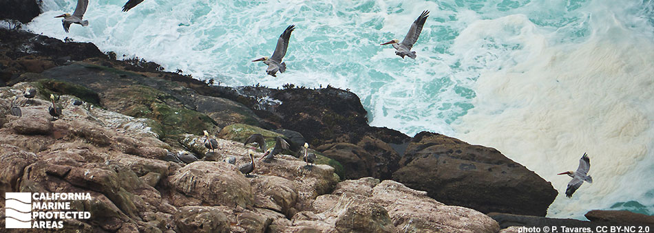
Point Resistance Rock Special Closure

pelicans glide beside a cliff, above turbulent water

Overview

Point Resistance Rock Special Closure is north of Kelham Beach along Point Reyes National Seashore in Marin County and protects a large offshore rock important to breeding seabirds. Named for the nearby rocky coastal point, the special closure prohibits public access within 300 feet to protect breeding and nesting seabirds from disturbance. Located along a remote sandy stretch of beach, this special closure safeguards Brandt's and pelagic cormorants, black oystercatchers, western gulls, common murres, pigeon guillemots, and brown pelicans from flushing and/or abandoning nests when disturbed.

The special closure is encompassed within Point Reyes National Seashore. The large outcropping is immediately surrounded by tidepools and a shallow intertidal zone, rich with sea stars, mussels, barnacles, owl limpets and small fish. Visitors of all ages can enjoy the numerous trails along these coastal bluffs with endless ocean views and abundant wildlife sightings. Point Resistance Rock is easily seen from Kelham Beach, and migrating birds and marine mammals frequent these waters.

Regulations

Boating and access are restricted. No person except employees of the California Department of Fish and Wildlife, United States Fish and Wildlife Service, National Park Service, or United States Coast Guard during performance of their official duties, or unless permission is granted by the California Department of Fish and Wildlife, shall enter the area.

California Code of Regulations Title 14, Section 632(b)(48)

Quick Facts

Special Closure size: 0.01 square miles

Depth range: 0 to 10 ft

Habitat composition:

  • Rock: 0.02 square miles

Photo Gallery

Video Gallery

California's MPA Network

About Point Resistance Rock Special Closure

Natural History

a dark green sea engulfs a steep rock with sea foam lapping at its edges, sea birds carpet the flat portions of the rock
Seabirds in Point Resistance Rock Special Closure. U.S. Fish and Wildlife Service photo

The geology of the Point Reyes area is associated with the San Andreas Fault Zone and continues to be an intriguing area for geological study. Ongoing sea-level rise is causing flooding and rocky sand to fill ancient valleys beneath Tomales Bay, Drakes Estero, and Bolinas Lagoon. Point Resistance Rock now sits offshore from the mainland by only a few hundred feet. Point Resistance Rock Special Closure was established to protect breeding common murres and roosting brown pelicans. Common murres are extremely vulnerable while breeding due to the heavy investment by both parents, who dedicate 90-135 days to one young per breeding season.

The special closure creates ideal nesting habitat, and a nearby abundance of food ensures the best chances of survival for both parents and young. Brown pelicans benefit from the minimal human disturbance, which increases survivorship of fledglings and improves nesting success. Point Reyes National Seashore, which covers 71,000 acres on the Point Reyes peninsula, also contains the highest diversity of bird species in the United States. An astounding 490 species, or 54% of all North American bird species, have been recorded in Point Reyes. These include fish-eating common murres, brown pelicans, and cormorants.

Cultural History

pelicans gliding next to a cliff, above turbulent water
Brown pelicans at Point Resistance Rock Special Closure. photo © P. Tavares, CC BY-NC 2.0

For centuries, Native American Tribes in California have relied on marine and coastal resources. Many Native American Tribes in California continue to regularly harvest marine resources within their ancestral territories and maintain relationships with the coast for ongoing customary uses. Point Reyes has a long history of human occupation, including the Coast Miwok whose presence on the peninsula stretches back thousands of years. The traditional Coast Miwok diet consists of several species of fish including halibut and rockfish, and invertebrates such as crabs, clams, mussels, abalone and oysters. Kule Loklo, a replica Miwok village run jointly by members of the Coast Miwok and California State Parks, is located near Point Reyes National Seashore's Bear Valley Visitor Center.

The first European landing in northern California occurred on June 17, 1579 on the southern side of Point Reyes, now known as Drakes Estero, by the Sir Francis Drake Expedition. Originally used as a safe harbor for trading vessels, the fertile land soon became home to Spanish settlement during the Missionary period until Mexico gained its independence from Spain in 1821. Kelham Beach is named after the Kelham family that owned Bear Valley property. They operated a cattle ranch and grazed animals until the National Park Service purchased the ranch for conservation. An automated lighthouse was installed by the U.S. Coast Guard below historic Point Reyes Lighthouse in 1975. A visitor center is open to the public and maintained by the National Park Service.

Recreation

top-down view of hundreds of seabirds on a large rock above sealevel
Common murres and brown pelicans in Point Resistance Rock Special Closure. U.S. Fish and Wildlife Service photo

Public access to Point Resistance Rock Special Closure is prohibited, however you can visit the beach just onshore to view the outcropping. Choose one of three different hiking trail options to access Kelham Beach, all of which are well mapped. The shortest option, about nine miles round trip, is Bear Valley trail. This is the single most popular trail in the Point Reyes National Seashore, a direct walk from Bear Valley Visitor Center to the ocean.

Visitors can watch for gray whales migrating south along the coast from mid-December through February, with a peak season around mid-January. Most of the year, common murres and brown pelicans can be easily admired with binoculars from the cliffside above Kelham Beach. Just north of Point Resistance Rock, the rocks of aptly named Sculptured Beach are exposed at low tide and offer exceptional tidepooling.

Coordinates

A special closure is designated from the mean high tide line to a distance of 300 feet seaward of the mean lower low tide line of any shoreline of Point Resistance Rock, located in the vicinity of 37° 59.916’ N. lat. 122° 49.759’ W. long.

California Code of Regulations Title 14, Section 632(b)(48)

Downloads for Point Resistance Rock Special Closure

Map

Map of Point Resistance Rock Special Closure - click to enlarge in new tab

Facts, Map & Regulations

MPA fact sheet - click to enlarge in new tab