Mattole Canyon State Marine Reserve

beach at sunset

Overview

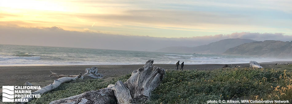
Mattole Canyon State Marine Reserve (SMR) consists of nearly 10 square miles of protected offshore waters within Humboldt County in northern California. This SMR protects submarine canyon, deep sandy seafloor, and offshore reef habitats. The deep submarine canyon, known as Mattole Canyon, extends into the sea from Mattole Valley, which is located on the adjacent, undeveloped stretch of coastline known as the Lost Coast. About three-quarters of a square mile of this marine protected area (MPA) is submarine canyon, with deep trenches where sablefish and thornyhead rockfish live.

This SMR ranges from 80 feet to nearly 1,650 feet deep in parts of the submarine canyon. The cold, rough waters are subject to seasonal upwelling that sends nutrients from the deep ocean into the water column, creating highly productive conditions. In the depths near the sandy seafloor, red octopus, petrale sole, kelp greenling, mushroom soft coral, and feather stars feed on plankton, shrimp or other crustaceans. Fields of white-plumed anemones dot the seafloor.

Regulations

It is unlawful to injure, damage, take, or possess any living, geological, or cultural marine resource.

California Code of Regulations Title 14, Section 632(b)(13)

Quick Facts

MPA size: 9.79 square miles

Depth range: 82 to 1,646 feet

Habitat composition:

  • Rock: 0.78 square miles
  • Sand: 9.02 square miles

About Mattole Canyon State Marine Reserve

Natural History

a group of rockfish in deep ocean water
Canary rockfish near Mattole Canyon SMR. CDFW/MARE photo

Mattole Canyon SMR encompasses part of a deep submarine canyon that formed along the continental margin, connecting the deep sea to the continental shelf. Mattole Canyon was carved out over a long period of time from constant erosion and sediment transport by swift ocean currents. Extending for nearly 17 miles, Mattole Canyon increases in depth until it merges with the Mendocino Canyon to the north.

Submarine canyons are geologically and biologically diverse, with a wide range of habitats that support diverse marine life, from soft corals to crustaceans, to deep-sea octopuses. Sandy seafloor habitats in Mattole Canyon lack the typical mounds and holes created by marine creatures because rapid currents sweep through the canyon and smooth out the seafloor sediments. The soft sandy seafloor is interspersed with patches of rocky reef, where canary rockfish, lingcod, and quillback rockfish find shelter from the rapidly flowing currents. Heavy seas, unpredictable currents, and strong winds have resulted in many shipwrecks along the Lost Coast.

Cultural History

a river meets the ocean below a steep hillside with old fencing and a shed
View of Mattole Canyon SMR and Mattole River from Prosper Ridge Rd. CDFW photo by M. Robbins

For centuries, Native American tribes in California have relied on marine and coastal resources. Many of the indigenous people in California continue to regularly harvest marine resources within their ancestral territories and maintain relationships with the coast for ongoing customary uses. Mattole Canyon is named for the Mattole Tribe, the indigenous people native to this stretch of Mendocino coast. The Mattole Tribe relied on harvesting food from the sea, including salmon and mollusks.

Most tribes were displaced when European settlers arrived. The 19th century gold rush brought more settlers, disrupting thousands of years of marine stewardship. Today, the Bear River Band of the Rohnerville Rancheria exists as a federally recognized tribe, with roots in the Cape Mendocino area. Mattole Canyon SMR is located about three miles north of Punta Gorda, one of the westernmost points in the continental United States. A lighthouse was established in 1912, accomplished with great effort due to the remote, rugged location and lack of roads.

After the Coast Guard assumed command of the lighthouse, a rough road was constructed in 1935 on the beach, but was often impassable, especially during winter months. In 1951, the Coast Guard placed a lighted whistle buoy offshore and decommissioned the Punta Gorda Light Station. Control of the Punta Gorda Lighthouse was transferred to the Bureau of Land Management (BLM). Groups of squatters took up residence in the buildings in the 1960s, and unable to keep people from residing there, BLM burned the wooden structures. Today, all that remains are the concrete lighthouse, oil house, and a few concrete pads where other structures once stood.

Recreation

gray and golden skies meet jagged coastline with sparse vegetation along sandy beaches
View from Mattole trailhead looking north near Mattole Canyon SMR. photo © C. Allison, MPA Collaborative Network

Adjacent to Mattole Canyon SMR is the Lost Coast, a remote and isolated expanse of wilderness. Mattole Trailhead lies at the mouth of Mattole River and is the northern entrance to the epic Lost Coast Trail that spans for roughly 25 miles through dramatic coastal landscapes. Mattole Canyon SMR is a no-take marine reserve; therefore, fishing is prohibited. Catch-and-release fishing for salmon and steelhead trout is popular in the nearby Mattole River, but regulations prohibit fishing within 200 yards of the river mouth.

In the waters outside of the Mattole Canyon SMR, recreational fishermen brave the turbulent seas in hopes of catching starry flounder, Dungeness crab, albacore, lingcod, and cabezon. To access the closest campground, turn off of Mattole Road onto Lighthouse Road and take the road about five miles to a BLM campground right on Mattole Beach.


Coordinates

This area is bounded by straight lines connecting the following points in the order listed except where noted:

40° 20.000′ N. lat. 124° 22.500′ W. long.;
40° 20.000′ N. lat. 124° 25.902′ W. long.; thence southward along the three nautical mile offshore boundary to
40° 17.000′ N. lat. 124° 25.869′ W. long.;
40° 17.000′ N. lat. 124° 22.500′ W. long.; and
40° 20.000′ N. lat. 124° 22.500′ W. long.

California Code of Regulations Title 14, Section 632(b)(13)

Mattole Canyon State Marine Reserve

Map

Map of Mattole Canyon State Marine Reserve - click to enlarge in new tab

Facts, Map & Regulations

MPA fact sheet - click to enlarge in new tab