Kashtayit State Marine Conservation Area

steep cliffsides extend out to the horizon paralleled by deep blue water, a wooden pier with a yellow boat crane extends into the ocean

Overview

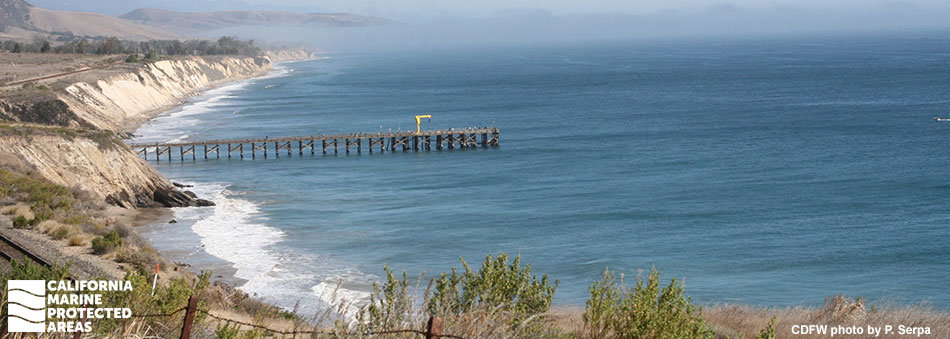
Kashtayit State Marine Conservation Area (SMCA) is a two-square-mile marine protected area (MPA) located just off Gaviota State Park, 30 miles west of Santa Barbara and 13 miles east of Point Conception. Set aside because of its cultural significance to Chumash peoples, this undeveloped area is a favorite for beachgoers, anglers, surfers, scuba and free divers, kayakers, and wildlife enthusiasts.

This MPA sits along Southern California’s largest stretch of undeveloped coastline, a 76-mile swath between Gaviota State Park in the south and Oceano to the north. Kashtayit SMCA is home to an array of marine life including rocky reef fishes, flatfish, sharks, birds, marine mammals, and invertebrates. It encompasses beaches, rocky shores, an expanse of surfgrass, sandy seafloor habitat, and a few offshore reefs. Located just off Highway 1, this MPA is easily accessible to anyone interested in exploring coastal California.

Regulations

It is unlawful to injure, damage, take, or possess any living, geological, or cultural marine resource, EXCEPT:
Recreational take of finfish, giant kelp by hand, and invertebrates except rock scallops and mussels is allowed. Includes take exemptions for the following tribe:

  • Santa Ynez Band of Chumash Indians

California Code of Regulations Title 14, Section 632(b)(97)(opens in new tab)

Quick Facts

MPA size: 2.02 square miles

Shoreline span: 1.9 miles

Depth range: 0 to 160 feet

Habitat composition*:

  • Rock: 0.44 miles
  • Sand/mud: 1.39 square miles

*Habitat calculations are based on 3-dimensional area and may exceed the total MPA area listed above.

Photo Gallery

Video Gallery

Southern California Marine Protected Area Highlights

California's MPA Network

About Kashtayit State Marine Conservation Area

Natural History

a wooden pier extends along the horizon, round moss covered and angular sandstone rocks extend from the sand meeting the ocean and pier
Gaviota Pier at Kashtayit SMCA. CDFW photo by T. Heitzenrater

Looking landward from the shore of Kashtayit SMCA, the peaks of the Santa Ynez mountains dominate the view. This mountain range is made of sandstone and schist, which have been uplifted over the last five million years by the Santa Ynez Fault and carved by water erosion into the canyons and bluffs present today.

The shoreline and underwater topography of Kashtayit SMCA reflect this inland geology. After millions of years of sandstone and shale erosion, the geology of the Southern California Bight (the curved coastline between Point Conception and San Diego and the area of the Pacific Ocean defined by that curve) is a complex mix of islands, banks, ridges, basins, troughs, and submarine canyons.

The nearshore rocky reefs and tidal areas of Kashtayit SMCA teem with rockfish, lingcod, and invertebrates such as California spiny lobsters and the critically endangered black abalone. White seabass, California halibut, cabezon and thresher sharks also frequent the MPA, inhabiting its sandy seafloor and surfgrass habitats. Southern sea otters occasionally pass through the area, although the absence of large kelp beds means that few spend long periods of time here.

Cultural History

people paddling a long boat on the ocean at sunset
Chumash tribal members paddle a tomol from Santa Cruz Island near Kashtayit SMCA. photo © R. Schwemmer/NOAA

For centuries, Native American Tribes in California have relied on marine and coastal resources. Many Native American Tribes in California continue to regularly harvest marine resources within their ancestral territories and maintain relationships with the coast for ongoing customary uses.

Kashtayit SMCA neighbors Gaviota State Park and a traditional Chumash village site. Kashtayit, or “place of the willow”, is the name of the small Chumash settlement that was located at the mouth of Gaviota Creek where an ancient grove of willow trees still flourishes. Archeological records of Chumash inhabitants reveal evidence of a complex society spanning from Malibu in the south to Morro Bay in the north, including the Channel Islands.

Chumash ancestors fostered societies of great complexity and adaptability, including well-established trade routes. The tomol, the traditional Chumash redwood plank canoe, was an essential part of prosperous trading and fishing. Today, contemporary Chumash peoples continue to nurture and revitalize the lifeways of those ancestors. Through a factual record of historical take within the Kashtayit SMCA, the Santa Ynez Band of Chumash Indians is exempt from MPA regulations.

A Spanish Crown fleet led by Juan Cabrillo journeyed through Santa Barbara Channel in 1542 and probably stopped at what is now Gaviota Beach. European settlement under the Spanish Crown did not begin here until 1786 when Mission Santa Barbara was built. Cattle ranching in the Gaviota/Hollister Ranch areas inland of Kashtayit SMCA started in 1790. The land was ranched through the time of Mexican independence (1821) and the Mexican-American War (1848), when the United States gained control over California.

Today, ranching has mostly ceased and the area between Gaviota and Point Conception remains largely undeveloped. A small pier built at Gaviota in 1875 was used to ship timber and other goods. In 1901, the Coast Route of the Southern Pacific Railroad was finished, linking San Francisco to the south coast for the first time. The large trestle railroad bridge at Gaviota is part of that railway and is still in use today.

Recreation

sitting in a shallow pool of water a group of sunburst anemones, dozens of vibrant green and purple tentacles spread in the water
Sunburst anemones in a tidepool at Kashtayit SMCA. photo © L. Boss, CC BY 2.0

More often than not, the beach that directly borders Kashtayit SMCA is a sunny, warm, and inviting spot for swimming, picnicking, and surf fishing. Parking, restrooms, a visitor center, and camping can all be found at Gaviota State Park, the main access point to Kashtayit SMCA, located right next to the MPA. 

The public pier on the west end of the beach at Gaviota, which has a boat hoist, may close periodically due to storm damage. For those looking to enjoy the MPA from the water, inflatable and very small craft may be launched from the beach adjacent to Gaviota Pier. Kayaking conditions are often excellent, although kayakers should be aware of the strong “sundowner” winds funneled through Gaviota Canyon in the evening, blowing offshore and sometimes making it difficult to return to the beach.

Recreational fishing for finfish is permitted within the MPA and the shallow, clear water makes for great conditions to go spearfishing for California halibut, which hide in the extensive surfgrass beds and sandy seafloor areas. The clear water is also great for snorkelers looking to explore life beneath the surface. Divers are welcome to harvest many of the invertebrates they find here, like California spiny lobster; however, rock scallops and mussels may not be harvested within Kashtayit SMCA.

Coordinates

This area is bounded by the mean high tide line and straight lines connecting the following points in the order listed:

34° 28.130' N. lat. 120° 14.460' W. long.; 
34° 27.300' N. lat. 120° 14.460' W. long.;
34° 27.300' N. lat. 120° 12.470' W. long.; and
34° 28.230' N. lat. 120° 12.470' W. long.

California Code of Regulations Title 14, Section 632(b)(97)

Downloads for Kashtayit State Marine Conservation Area

Map

Map of Kashtayit State Marine Conservation Area - click to enlarge in new tab

Facts, Map & Regulations

MPA fact sheet - click to enlarge in new tab