Estero de Limantour State Marine Reserve, and Drakes Estero State Marine Conservation Area

rounded brown cliffs roll into a windy snake-like estuary, the blue sky is contrasted with the golden glow of sunset along the horizon, this reflection makes the estuary glow blue contrasting the brown land around it

Overview

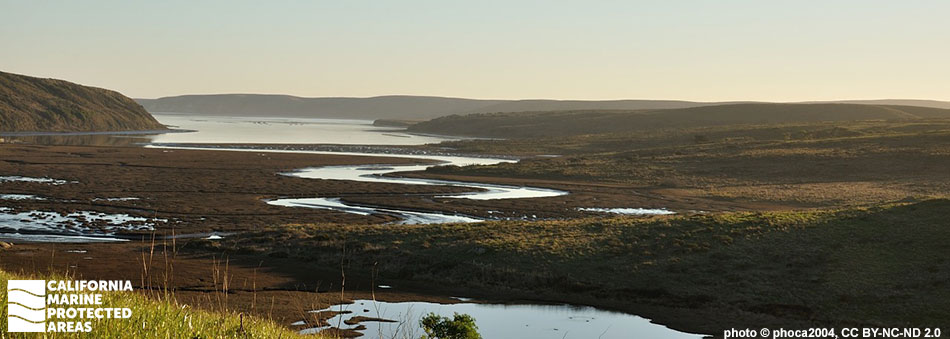
Estero de Limantour State Marine Reserve (SMR) and Drakes Estero State Marine Conservation Area (SMCA) are two neighboring estuarine marine protected areas (MPAs) located near Point Reyes. About 90 minutes from San Francisco in Marin County, Estero de Limantour SMR protects nearly 1½ square miles of sandy beaches, rocky shores, and estuarine habitat including tidal flats, coastal marsh, sandy seafloor, and eelgrass beds. Its neighbor, Point Reyes SMR, protects another approximately 9½ square miles of ocean waters, providing continuity between nearshore and estuarine habitats. Drakes Estero SMCA, to the north of Estero de Limantour SMR, covers 2½ miles of tidal mudflats, coastal marsh, sand/mud estuary bottom, and eelgrass beds.

The estuaries are also part of the Point Reyes National Seashore and Phillip Burton Wilderness. A popular destination for hikers, wildlife enthusiasts, bird watchers, and kayakers, Estero de Limantour SMR and Drakes Estero SMCA offer visitors an escape and the chance to see hundreds of species of birds, mammals, and fish. These MPAs serve as nurseries for Dungeness crab and various fish species, as well as harbor seal pupping areas and haul-out sites for marine mammals, and major foraging areas for leopard sharks, bat rays, and many bird species including black brant geese and brown pelicans.

Regulations

Estero de Limantour SMR

It is unlawful to injure, damage, take, or possess any living, geological, or cultural marine resource.

California Code of Regulations Title 14, Section 632(b)(46)(opens in new tab)

Drakes Estero SMCA

It is unlawful to injure, damage, take, or possess any living, geological, or cultural marine resource, EXCEPT:
Recreational take of clams is allowed.

California Code of Regulations Title 14, Section 632(b)(47)(opens in new tab)

Quick Facts

Estero de Limantour SMR

MPA size: 1.45 square miles

Shoreline span: 1.2 miles

Depth range: 0 to 10 feet

Habitat composition*:

  • Estuary: 1.27 square miles
  • Eelgrass: 0.22 square miles
  • Coastal marsh: 1.61 square miles

Drakes Estero SMCA

MPA size: 2.50 square miles

Shoreline span: 0.6 miles

Depth range: 0 to 10 feet

Habitat composition*:

  • Estuary: 2.40 square miles
  • Eelgrass: 1.16 square miles
  • Coastal marsh: 2.76 square miles

*Habitat calculations are based on 3-dimensional area and may exceed the total MPA area listed above.

Photo Gallery

Video Gallery

California's MPA Network

About Estero de Limantour State Marine Reserve, and Drakes Estero State Marine Conservation Area

Natural History

a Spanish shawl, a type of nudibranch also known as a sea slug rest  in a tidepool, this creature has a deep purple body with vibrant fiery orange pointed growths on its back
Spanish shawl nudibranch in a tidepool in Estero de Limantour SMR. photo © J. Goddard, CC BY-NC 2.0

The Estero de Limantour SMR and Drakes Estero SMCA protect important estuarine habitat including tidal creeks, beaches, rocky shore, tidal flats, coastal marsh, sandy seafloor, and eelgrass beds. The eelgrass beds are beneficial to both humans and wildlife. Eelgrass oxygenates coastal waters and sediments, helps protect shorelines from erosion through vast networks of shallow roots, stabilizes sediments, and is highly effective in carbon sequestration. Eelgrass also provides important habitat for seabirds, waterfowl, fish, and many species of invertebrates. Dungeness crab, rockfish, and flatfish depend on eelgrass beds for vital nursery habitat.

Black brant are commonly seen in the area feeding on the eelgrass. An astounding 490 species, or 54 percent of all North American bird species, have been recorded in the Point Reyes area. Great blue herons and kingfishers can be found patrolling the shallow waters for small fish and crustaceans, brown pelicans cruise just above the water, and common murres dive beneath the surface while foraging. Along the banks of the MPAs, a large harbor seal breeding colony can be spotted while they rest on shore, and tule elk may occasionally be seen near the water’s edge.

Cultural History

a white pelican rests on flat dark blue waters, a few western gulls are off along the horizon
American white pelican and western gulls in Drakes Estero SMCA. photo © L.J.M. McClelland, CC BY-NC 2.0

For centuries, Native American Tribes in California have relied on marine and coastal resources. Many Native American Tribes in California continue to regularly harvest marine resources within their ancestral territories and maintain relationships with the coast for ongoing customary uses. Point Reyes has a long history of human occupation, including the Coast Miwok whose presence on the peninsula stretches back thousands of years. The traditional Coast Miwok diet consists of several species of fish including halibut and rockfish, and invertebrates such as crabs, clams, mussels, abalone and oysters. Kule Loklo, a replica Miwok village run jointly by members of the Coast Miwok and California State Parks, is located near Point Reyes National Seashore's Bear Valley Visitor Center.

The first European landing in northern California occurred on June 17, 1579 on the southern side of Point Reyes, now known as Drakes Estero, by the Sir Francis Drake Expedition. Originally used as a safe harbor for trading vessels, the fertile land soon became home to Spanish settlement during the Missionary period until Mexico gained its independence from Spain in 1821. Point Reyes was then used as ranchland and dairy pasture, undergoing several ownership changes until 1962, when it was purchased by the National Park Service for conservation purposes. Drakes Bay Oyster Company, a commercial oyster farm, operated in Drakes Bay for more than 100 years and recently closed.

Following this closure, Drakes Estero has undergone extensive restoration efforts to remove oyster racks and other debris from the area. This restoration opens the area for eelgrass beds to establish in the space once occupied by the oyster farm. An automated lighthouse was installed by the U.S. Coast Guard below the historic Point Reyes Lighthouse in 1975. There is now a visitor center open to the public and maintained by the National Park Service.

Recreation

rocks speckle rough sand off into the horizon, attached on the rocks near the waterline, long swaths of wavy green algae, called sea lettuce
Sea lettuce, a type of green algae, in Estero de Limantour SMR. photo © L. Zentall, CC BY-NC 2.0

Estero de Limantour SMR and Drakes Estero SMCA are ideal locations for observing wildlife and appreciating the natural beauty of the surrounding land and seascape. Hikers have access to miles of trails to observe the MPAs and watch birds hunt along the mudflats, rest on the calm waters, and glide above the water's surface. Harbor seals may be seen resting on the sandy banks next to the estuary or swimming through the water. Kayakers will have the same opportunity to see wildlife as land-based explorers but with the added benefit of looking into the protected waters.

On calm weather days, leopard sharks and bat rays may be seen hunting for clams across the soft sediment, while crabs become visible scurrying over rocks when the tide recedes. No take is permitted in Estero de Limantour SMR, while Drakes Estero SMCA allows for recreational clamming, but no other take is permitted. Parking and bathrooms are available at the Drakes Estero Trailhead and Limantour Beach. Nearly all of Point Reyes, including Drakes Estero, is designated as a National Seashore.

Coordinates

Estero de Limantour SMR

This area consists of waters below the mean high tide line within Estero de Limantour and within Drakes Estero, southward of a line connecting the following two points:

38° 02.660' N. lat. 122° 56.900' W. long.; and
38° 02.660' N. lat. 122° 56.150' W. long.
and northward of a line connecting the following two points:
38° 01.783' N. lat. 122° 55.286' W. long.; and
38° 01.941' N. lat. 122° 56.364' W. long.

California Code of Regulations Title 14, Section 632(b)(46)

Drakes Estero SMCA

This area includes the waters below the mean high tide line within Drakes Estero northward of a line connecting the following two points:

38° 02.660' N. lat. 122° 56.900' W. long.; and
38° 02.660' N. lat. 122° 56.150' W. long.

California Code of Regulations Title 14, Section 632(b)(47)

Downloads for Estero de Limantour State Marine Reserve

Map

Map of Estero de Limantour State Marine Reserve - click to enlarge in new tab

Facts, Map & Regulations

MPA fact sheet - click to enlarge in new tab

Downloads for Drakes Estero State Marine Conservation Area

Map

Map of Drakes Estero State Marine Conservation Area - click to enlarge in new tab

Facts, Map & Regulations

MPA fact sheet - click to enlarge in new tab