Lovers Point-Julia Platt State Marine Reserve, and Edward F. Ricketts State Marine Conservation Area

bike trail winds around rocky shoreline

Overview

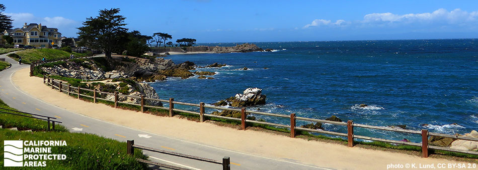
Lovers Point-Julia Platt State Marine Reserve (SMR) and Edward F. Ricketts State Marine Conservation Area (SMCA) are two of four marine protected areas (MPAs) located on the Monterey Peninsula between Monterey and Pacific Grove. Edward F. Ricketts SMCA is named after the famous 20th century marine biologist who owned a biological supply house on Cannery Row. This nearly quarter square mile MPA stretches along shore for one mile, from the Monterey Coast Guard Jetty to the western edge of the Monterey Bay Aquarium.

The first part of Lovers Point-Julia Platt SMR’s name stems from the headland, Lovers Point, while the second part honors Julia Platt, a marine biologist who became the mayor of Pacific Grove in the 1930s and petitioned the state of California to allow the city to protect its own coastline. Lovers Point-Julia Platt SMR covers just under a half square mile of marine ecosystems off Pacific Grove, which includes a mix of sandy beaches and rocky shoreline, rocky reefs, surfgrass, and kelp forest, with a maximum depth of around 90 feet. The small SMR protects an area that is home to renowned scuba diving, kayaking, surfing, and wildlife viewing. The waters of Edward F. Ricketts SMCA reach about 70 feet deep, and are characterized by sandy beach, rocky shore, surfgrass, and kelp habitats in an area long subjected to human activity.

Surfgrass dominates the shallow subtidal area of both MPAs, offering refuge to a variety of invertebrates such as crabs and shrimp, marine worms and snails, and small fish. Located at the edge of the highly productive waters of Monterey Bay, sea otters forage in both MPAs' thick kelp canopies, while sea lions and harbor seals bask on rocky shores. Other marine mammals like humpback whales, Risso’s dolphins, and elephant seals frequently feed on the abundant krill, crabs, and shrimp. Cabezon and rockfish, along with invertebrates such as limpets, mussels, and abalone, are very common in the kelp canopy and rocky intertidal area. No take is allowed in the SMR, and the only take allowed from the SMCA is recreational take of finfish by hook-and-line and a limited amount of commercial take of giant kelp and bull kelp harvested by hand.

Regulations

Lovers Point-Julia Platt SMR

It is unlawful to injure, damage, take, or possess any living, geological, or cultural marine resource.

California Code of Regulations Title 14, Section 632(b)(76)(opens in new tab)

Edward F. Ricketts SMCA

It is unlawful to injure, damage, take, or possess any living, geological, or cultural marine resource, EXCEPT:
Recreational take of finfish by hook-and-line only is allowed. Commercial take of giant kelp and bull kelp by hand is allowed.

California Code of Regulations Title 14, Section 632(b)(75)(opens in new tab)

Quick Facts

Lovers Point-Julia Platt SMR

MPA size: 0.30 square miles

Shoreline span: 0.9 miles

Depth range: 0 to 88 feet

Habitat composition:

  • Sand/mud: 0.38 square miles
  • Rock: 0.14 square miles

Edward F. Ricketts SMCA

MPA size: 0.23 square miles

Shoreline span: 0.7 miles

Depth range: 0 to 74 feet

Habitat composition:

  • Sand/mud: 0.16 square miles
  • Rock: 0.17 square miles

Photo Gallery

Video Gallery

California's MPA Network

About Lovers Point-Julia Platt State Marine Reserve, and Edward F. Ricketts State Marine Conservation Area

Natural History

closeup of kelp branches
Giant kelp in Lovers Point-Julia Platt SMR. photo © S. Lonhart, CC BY-NC 2.0

Tucked away on the east-facing side of the Monterey Peninsula, Lovers Point-Julia Platt SMR and Edward F. Ricketts SMCA are protected from much of the swell that frequently batters the surrounding coastline. Further offshore in the Monterey Bay lies the Monterey Canyon, a submarine canyon that reaches nearly 12,000 feet at its deepest point, almost twice as deep as the Grand Canyon. The MPAs are primarily dominated by rocky intertidal, nearshore kelp forest, and interspersed patches of sandy seafloor. Upwelling causes cold, nutrient-rich waters to rise from the depths of the canyon, creating a remarkably productive ecosystem.

These nutrient-rich waters teem with krill at certain times of the year, with phytoplankton and zooplankton serving as the base of the food chain. Schools of northern anchovies occur seasonally, as do important baitfish that are prey items for larger fish, seabirds, and marine mammals. In the giant kelp forests, sea urchins and bat stars can be found feeding on kelp fronds. California sheephead pry their hard-shelled prey off rocks, while swell sharks, and California halibut forage along the sandy seafloor. From small invertebrates to blue whales, Monterey Bay is home to an impressive array of marine life.

Cultural History

school of slender silver fish
Northern anchovies in Edward F. Ricketts SMCA. photo © A. Jaramillo, CC BY-NC 2.0

For centuries, Native American Tribes in California have relied on marine and coastal resources. Many Native American Tribes in California continue to regularly harvest marine resources within their ancestral territories and maintain relationships with the coast for ongoing customary uses. The Monterey Peninsula has a long history of human residence, with the Ohlone peoples occupying the area for thousands of years. The Ohlone traditionally subsisted on the abundant marine and terrestrial resources in Monterey, collecting abalone, urchins, limpets, and seaweeds in rocky intertidal areas.

The first European visitor to the area was the Spanish explorer Sebastian Vizcaino, who named the area Bahia de Monterey when he anchored his fleet in the calm waters near Lovers Point while in search of a northwest passage across the continent. In the period following Vizcaino’s brief visit, Monterey remained free from significant European influence until the Portola Expedition of 1769, and beginning of the Mission Era of California. The construction of Mission Carmel on the southern side of the Monterey Peninsula occurred one year later in 1770. In the early 1850s, Chinese immigrants brought sophisticated fishing techniques and Monterey emerged as a thriving fishing port. Commercial fisheries for abalone, rockfish, flatfish, sardines, and squid expanded. The canneries brought further commercialization, with Monterey adopting the name "The Sardine Capital of the World".

Between 1915 and 1950, roughly 235,000 tons of sardine were fished from the bay annually, until the fishery collapsed. Similar collapses of other fish stocks resulted in more stringent regulations. As fishing waned, conservation efforts gained momentum leading to the creation of Monterey Bay National Marine Sanctuary. Protection efforts continued, and Lovers Point-Julia Platt SMR and Edward F. Ricketts SMCA were established in 2007 as two of 29 MPAs adopted during the first phase of the Marine Life Protection Act Initiative along California’s Central Coast.

Recreation

cabezon
Cabezon in Edward F. Ricketts SMCA. photo © Stefanie, CC BY-NC 2.0

These MPAs lie within Monterey Bay National Marine Sanctuary, which covers more than 6,000 square miles. The area is popular for kayak fishing and diving. Access is available at San Carlos Beach. One of the best ways to explore the area is by renting a kayak. Recreational fishing for finfish using hook-and-line is allowed in Edward F. Ricketts SMCA, so anglers can come to this stretch of coast near Pacific Grove to cast their lines in hopes of catching lingcod, cabezon, kelp greenling, and more.

The Monterey Bay Aquarium borders the SMCA and exhibits environments found in the Monterey Bay, offering a unique opportunity to view and learn about the world beneath the waves. With their location in the heart of Monterey, restaurants, lodging, and other amenities are within easy reach. For those wanting to get out on the water, kayaks and boats can be both launched and rented at nearby Monterey Harbor.

Coordinates

Lovers Point-Julia Platt SMR

This area is bounded by the mean high tide line and straight lines connecting the following points in the order listed:

36° 37.100′ N. lat. 121° 54.093′ W. long.;
36° 37.250′ N. lat. 121° 53.780′ W. long.;
36° 37.380′ N. lat. 121° 53.850′ W. long.;
36° 37.600′ N. lat. 121° 54.750′ W. long.; and
36° 37.600′ N. lat. 121° 54.919′ W. long.

California Code of Regulations Title 14, Section 632(b)(76)

Edward F. Ricketts SMCA

This area is bounded by the mean high tide line and straight lines connecting the following points in the order listed:

36° 36.508′ N. lat. 121° 53.379′ W. long.;
36° 37.250′ N. lat. 121° 53.780′ W. long.; and
36° 37.100′ N. lat. 121° 54.093′ W. long.

California Code of Regulations Title 14, Section 632(b)(75)

Downloads for Lovers Point-Julia Platt State Marine Reserve

Map

Map of Lovers Point Julia Platt State Marine Reserve - click to enlarge in new tab

Facts, Map & Regulations

MPA fact sheet - click to enlarge in new tab

Downloads for Edward F. Ricketts State Marine Conservation Area

Map

Map of Edward F. Ricketts State Marine Conservation Area - click to enlarge in new tab

Facts, Map & Regulations

MPA fact sheet - click to enlarge in new tab