Double Point/Stormy Stack Rock Special Closure

rocky coastline

Overview

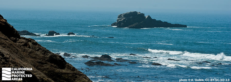
Double Point/Stormy Stack Rock Special Closure is located a few miles north of Duxbury Reef State Marine Conservation Area in Marin County. Stormy Stack Rock is a pinnacle that sits roughly 800 feet from shore at the north end of the Double Point Area of Special Biological Significance. Adjacent to Stormy Stack Rock, the characteristic rugged sea cliffs of Double Point extend into the ocean in two places, encompassing a crescent-shaped sandy beach where harbor seals haul out to breed. The special closure was established in 2010, creating a 300-foot buffer around Stormy Stack Rock to protect this special bird rookery and marine mammal haul-out site from human disturbances year-round.

One of California’s 14 special closures, Double Point/Stormy Stack Rock Special Closure boasts the second largest bird rookery along this stretch of coast. Brandt’s cormorants, brown pelicans, pigeon guillemots, and ashy storm-petrels fly overhead and nest on this offshore rocky landscape. California sea lions haul out on the exposed shores of Stormy Stack Rock as they take a break from feeding in the surrounding waters that are rich with salmon, lingcod, and halibut.

Regulations

Boating and access are restricted. No person except employees of the California Department of Fish and Wildlife, United States Fish and Wildlife Service, National Park Service, or United States Coast Guard during performance of their official duties, or unless permission is granted by the California Department of Fish and Wildlife, shall enter the area.

California Code of Regulations Title 14, Section 632(b)(49)(opens in new tab)

Quick Facts

Special Closure size: 0.02 square miles

Depth: 0 to 32 feet

Habitat composition*:

  • Sand/mud: 0.01 square miles
  • Rock: 0.04 square miles

*Habitat calculations are based on 3-dimensional area and may exceed the total MPA area listed above.

Video Gallery

California's MPA Network

About Double Point/Stormy Stack Rock Special Closure

Natural History

aerial view of a many seabirds perched on a large rock
Brown pelicans, cormorants, and common murres at Double Point/Stormy Stack Rock Special Closure. U.S. Fish and Wildlife Service photo

Stormy Stack Rock juts out of the cold Pacific waters along the rugged northern California coastline. Many of the rocky outcroppings off the California coast, like Stormy Stack Rock, have been shaped over thousands of years from constant wind and wave action.

Today, the craggy surface and crevices in the rock provide ideal habitat for nesting seabirds, while rocky shores near the water’s edge attract sea lions and seals looking for a place to rest. This small special closure was designed to protect Stormy Stack Rock from human disturbances, like boat traffic, since it is such an important bird rookery and marine mammal haul out site. Common murres, ashy storm-petrels, pelagic cormorants, and Brandt’s cormorants are a few of the species of birds that rely on this rocky outcropping. The proximate waters are teeming with lingcod, halibut, striped bass, salmon and many species of rockfish. Gray whales may also be seen as they pass by during their long migrations from Mexico to Alaska.

Cultural History

fins protrude from ocean
Gray whales near Double Point/Stormy Stack Rock Special Closure. photo © J. Winer, CC BY-NC 2.0

For centuries, Native American Tribes in California have relied on marine and coastal resources. Many Native American Tribes in California continue to regularly harvest marine resources within their ancestral territories and maintain relationships with the coast for ongoing customary uses.

The Coast Miwok peoples were the original inhabitants of the Marin County coast, including lands adjacent to Double Point/Stormy Stack Rock Special Closure. The traditional Coast Miwok diet consists of several species of fish including halibut and rockfish, and invertebrates such as crabs, clams, mussels, abalone, and oysters. Kule Loklo, a replica Miwok village run jointly by members of the Coast Miwok and California State Parks, is located near Point Reyes National Seashore's Bear Valley Visitor Center.

The first European landing in this area occurred on June 17, 1579 on the southern side of Point Reyes, now known as Drakes Estero, by the Sir Francis Drake Expedition. In the late 1700s and early 1800s, Spanish explorers reached the area and began building missions, including Mission San Rafael, located less than 20 miles east of Double Point. When larger groups of Europeans began to arrive in the 1800s, the Coast Miwok peoples were quickly displaced.

Recreation

steep rock hillside emerging from ocean
Looking northwest near Double Point/Stormy Stack Rock Special Closure. photo © Bright-Spider, CC BY-NC 2.0

Sandwiched between the quaint beach town of Bolinas and the vast, breathtaking landscapes in Point Reyes National Seashore, Double Point/Stormy Stack Rock Special Closure lies along a stretch of coast that receives relatively little foot traffic. Highway 1 runs a few miles to the east of the shoreline, but hikers can reach the coast by taking the Palomarin Trail which winds through vegetation and passes multiple small lakes. This trail also leads to Alamere Falls, an incredible seasonal waterfall that cascades over a steep cliff and into the Pacific Ocean at the south end of Wildcat Beach, adjacent to the Double Point Headlands.

Standing near Alamere Falls, you can catch a glimpse of Stormy Stack Rock offshore, with birds swarming its rocky shores. This stretch of coast is also a popular area for whale watching, as humpback whales and gray whales can often be seen from the shore. Wildcat Campground is the closest campground to the Double Point/Stormy Stack Rock Special Closure and is located on a clifftop meadow, with direct access to Wildcat Beach.

Coordinates

A special closure is designated from the mean high tide line to a distance of 300 feet seaward of the mean lower low tide line of any shoreline of Stormy Stack Rock, located in the vicinity of 37° 56.830’ N. lat. 122° 47.140’ W. long.

California Code of Regulations Title 14, Section 632(b)(49)

Downloads for Double Point/Stormy Stack Rock Special Closure

Map

Map of Double Point/Stormy Stack Rock SC - click to enlarge in new tab

Facts, Map & Regulations

MPA fact sheet - click to enlarge in new tab