Big River Estuary State Marine Conservation Area

a river with sandy beach winds between forested hills

Overview

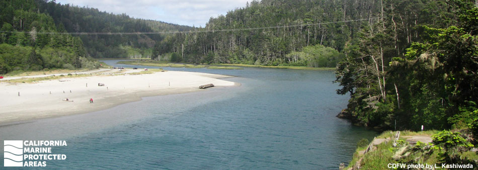
Big River Estuary State Marine Conservation Area (SMCA) is located to the southeast of the town of Mendocino, a small coastal village 150 miles north of San Francisco. Surrounded by Mendocino Headlands State Park, Big River Estuary SMCA runs east from Highway 1 for slightly more than one mile. This estuarine marine protected area (MPA), with a maximum depth of almost 20 feet, offers marine and brackish water habitat for fish and invertebrates that tolerate extreme variation in salt content and temperature. The protected inland estuary provides spawning and nursery grounds for shorebirds and waterfowl, feeding areas for harbor seals and sea lions, and habitat and a transportation corridor for river otters. With numerous coastal access points close to several population centers, it offers many research, long-term monitoring, and recreational opportunities.

Regulations

It is unlawful to injure, damage, take, or possess any living, geological, or cultural marine resource, EXCEPT:

Recreational take of surfperch by hook-and-line from shore only, and Dungeness crab by hoop net or hand is allowed. Take of waterfowl in accordance with general waterfowl hunting regulations is allowed. Includes take exemptions for the following tribes:

  • Big Valley Band of Pomo Indians of the Big Valley Rancheria
  • Cahto Indian Tribe of the Laytonville Rancheria
  • Coyote Valley Band of Pomo Indians
  • Elem Indian Colony of Pomo Indians of the Sulphur Bank Rancheria
  • Guidiville Rancheria
  • Habematolel Pomo of Upper Lake
  • Hopland Band of Pomo Indians of the Hopland Rancheria
  • Lower Lake Rancheria
  • Manchester Band of Pomo Indians of the Manchester-Point Arena Rancheria
  • Middletown Rancheria of Pomo Indians
  • Pinoleville Pomo Nation
  • Potter Valley Tribe
  • Redwood Valley Rancheria of Pomo Indians
  • Robinson Rancheria of Pomo Indians
  • Round Valley Indian Tribes of the Round Valley Reservation
  • Scotts Valley Band of Pomo Indians
  • Sherwood Valley Rancheria of Pomo Indians

California Code of Regulations Title 14, Section 632(b)(25)(opens in new tab)

Quick Facts

MPA size: 0.13 square miles

Shoreline span: 0.1 miles

Habitat composition*:

  • Estuary: 0.12 square miles
  • Coastal marsh: 0.47 square miles

*Habitat calculations are based on 3-dimensional area and may exceed the total MPA area listed above.

Photo Gallery

Video Gallery

California's MPA Network

About Big River Estuary State Marine Conservation Area

Natural History

great blue heron in flight
Great blue heron at Big River Estuary SMCA. photo © Sam, CC BY-NC 2.0

Ocean tides influence the lower four miles of Big River, including the SMCA. Saltwater can extend as far as eight miles upstream in the summer when river flow is low, and about three miles upstream in the winter when river flow is at its greatest. The brackish estuary environment supports numerous plants, birds, fish, and other animals.

However, since 1890 more than half of the tidal estuary has been buried in sediments that transformed it into a salt marsh. These marshy areas are saturated with saltwater during high tides and inundated with fresh water during high river flows, providing a constantly changing and dynamic environment suitable for juvenile salmon and some other fish, along with amphibians like frogs, newts, and salamanders.

Dungeness crabs, ghost shrimp, and other invertebrates use the estuary for food, shelter, and nursery grounds. More than 20 species of fish, including seven species of surfperch, and more than 100 species of birds can be spotted in Big River Estuary. Big River, Noyo River, and Ten Mile River have the highest abundance of coho and Chinook salmon and steelhead trout in Mendocino County.

River otters and harbor seals are regularly spotted by kayakers on the water. Bird surveys show that many fish-eating birds reside in or visit Big River Estuary. Kayakers have the best chance of seeing birds on the estuary, from ducks dabbling in the water to osprey diving for fish to the great blue herons that raise their young in the trees lining the estuary.

Cultural History

short posts emerge from water at river's edge
Pilings from the old mill site at Big River Estuary SMCA. photo © L. Kashiwada

For centuries, Native American Tribes in California have relied on marine and coastal resources. Many Native American Tribes in California continue to regularly harvest marine resources within their ancestral territories and maintain relationships with the coast for ongoing customary uses. Big River Estuary SMCA is located within the territory of Northern Coast Pomo people known as Búl-dám Pó-ma. Through a factual record of historical take within the Big River Estuary SMCA, several tribes are exempt from the MPA regulations.

The history of early settlement in the area is poorly documented prior to the start of the timber industry in the 1850s. The first steam-powered lumber mill on the Mendocino coast was built on the bluffs overlooking the mouth of Big River in 1852. After the operation at the original mill was phased out, and the second mill was destroyed by fire in 1863, a new mill was built in 1864 and operated until it closed permanently at the end of 1938. The only visible remains of this activity are old wooden pilings on the north side of the estuary.

Big River was dammed in numerous locations to create higher water flows to transport logs downstream to mills. When rains filled the dams, the dams were opened to create sufficient water to float the logs downstream. Often a year’s worth of logging effort was moved down to the estuary in one “swamping”. Logging activity, including harvest, transport, and milling, impacted the natural environment in and near Big River Estuary, damaging the riverbeds essential for salmon spawning. In the late 1990s local activists organized a national campaign to preserve local forests resulting in the purchase and transfer of more than 7,300 acres to State Parks in 2002. This includes land adjacent to what is now Big River SMCA, which was established in 2012.

Recreation

kayaker on river
Kayaker on Big River. photo © L. Kashiwada

Some of the most popular activities within Big River Estuary SMCA are kayaking, stand-up paddle boarding, canoeing, and swimming. If you are planning to travel on the river, it is important to pay attention to the tides. It is recommended to go upstream with the incoming tide and return with the outgoing tide. The offshore breeze often picks up in the afternoon, which can create challenging conditions for the return journey.

In this MPA, surfperch may be taken by hook-and-line from shore, Dungeness crab may be taken by hoop net or hand, and waterfowl may be taken in accordance with current waterfowl regulations. Take of other species of fish and invertebrates can only occur west of Highway 1 or inland beyond the eastern boundary of the SMCA.

Near the northwest border of Big River Estuary there is a wide beach, well-suited for gatherings, picnics, beach games, wading, and swimming. Dogs are allowed on this beach, but must always be leashed. Park near Big River Beach for access to Big River Trail, a multi-use trail that runs eastward for miles on the high bank above the river. Exploring this trail from Big River Bridge (Highway 1) heading east for a little more than one mile will offer visitors a chance to view Big River SMCA from shore. Visitors can continue along this trail far beyond the MPA boundary and explore the Big River Unit of Mendocino Coast Headlands State Park.

Coordinates

This area consists of waters below the mean high tide line within the Big River Estuary, eastward of a line connecting the following two points:

39° 18.134 ′ N. lat. 123° 47.517 ′ W. long.; and
39° 18.070 ′ N. lat. 123° 47.543 ′ W. long.

and westward of a line connecting the following two points:
39° 18.222 ′ N. lat. 123° 46.242 ′ W. long.; and
39° 18.150 ′ N. lat. 123° 46.240 ′ W. long.

California Code of Regulations Title 14, Section 632(b)(25)

Downloads for Big River Estuary State Marine Conservation Area

Map

Map of Big River Estuary State Marine Conservation Area - click to enlarge in new tab

Facts, Map & Regulations

MPA fact sheet - click to enlarge in new tab