Batiquitos Lagoon State Marine Conservation Area (No-Take)

lagoon surrounded by grassy shores and cliffs

Overview

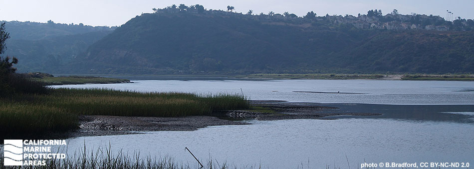
Batiquitos Lagoon State Marine Conservation Area (SMCA) (No-Take) is a marine protected area (MPA) in northern San Diego County that protects around a half-square-mile of a large estuary system in the heart of developed coastal Southern California. Located in south Carlsbad, just north of Encinitas, Batiquitos Lagoon SMCA (No-Take) protects an environmentally important estuary with marsh, mudflats, and eelgrass habitat. Native American historical sites surround the coastal lagoon, as well.

The restored estuary is home to dozens of species of fish including turbot, croakers, bass, and sardines, some of which use the estuary as a breeding ground. It also acts as a stopover for migratory birds and supports a rich community of invertebrates, sharks, rays, birds, and plants including many that are endangered. Batiquitos Lagoon SMCA (No-Take) offers excellent hiking and birdwatching with an easy-access trail system.

Regulations

It is unlawful to injure, damage, take, or possess any living, geological, or cultural marine resource. Take incidental to certain permitted activities may be allowed. Other restrictions may apply. See CCR T14 §632(b) for details.

California Code of Regulations Title 14, Section 632(b)(137)(opens in new tab)

Quick Facts

MPA size: 0.51 square miles

Habitat composition*:

  • Estuary: 0.47 square miles
  • Eelgrass: 0.16 square miles
  • Coastal marsh: 1.60 square miles

*Habitat calculations are based on 3-dimensional area and may exceed the total MPA area listed above.

Photo Gallery

Video Gallery

Southern California Marine Protected Area Highlights

California's MPA Network

About Batiquitos Lagoon State Marine Conservation Area (No-Take)

Natural History

bat ray wings appear above lagoon water
A bat ray in the Batiquitos Lagoon. Photo © B. Bradford, CC BY-NC-ND 2.0

Sand and sediment flows through the creeks that feed Batiquitos Lagoon, settling out into a mix of sandy bottom and estuary ecosystems. The marshy areas are interspersed with cobbles, eelgrass beds, tidal flats, and murky open water, with each ecosystem offering refuge to a different suite of species. Eelgrass beds give rise to well documented biodiversity and are beneficial to both humans and wildlife. Eelgrass beds oxygenate coastal waters and sediments, help protect shorelines from erosion through vast networks of shallow roots, stabilize sediments, and are highly effective in carbon sequestration. Eelgrass provides critical habitat for seabirds, waterfowl, fish, and the many invertebrates that inhabit the SMCA.

Residents of the estuary include leopard sharks, bat rays, pipefish, gobies, mullet, and California killifish. Batiquitos Lagoon SMCA (No-Take) provides habitat for an important part of the life cycle for many fish and invertebrates, which use the area as a nursery for their larvae and young, including California halibut, Pacific staghorn sculpin, and many other biologically and commercially important species. The lagoon is also a crucial breeding ground for offshore fish and a migratory stopover for birds. More than 200 species of birds have been recorded at Batiquitos Lagoon, several of which are endangered, including western snowy plovers, Ridgway’s rails, and California least terns. The wetland lagoon also acts as a natural water filter, cleaning water before it enters the sea.

Cultural History

view of bridge over lagoon at sunset
Looking west from the Batiquitos Lagoon. Photo © B. Bradford, CC BY-NC-ND 2.0

For centuries, Native American Tribes in California have relied on marine and coastal resources. Many Native American Tribes in California continue to regularly harvest marine resources within their ancestral territories and maintain relationships with the coast for ongoing customary uses. Batiquitos Lagoon SMCA (No-Take) is located at the border of the Kumeyaay and Luiseño territories. Both peoples used the productive area as a source of food and resources, harvesting mollusks, other shellfish, fish, seals, and sea lions. Evidence of this use can be found in the many middens (heaps of discarded seashells) that surround the lagoon.

European exploration began with the Portola Expedition in 1769, and settlement started with the San Luis Rey Mission in 1798. As Spanish settlement increased, cattle ranching and large-scale agriculture changed the landscape, resulting in the loss of the once abundant estuarine life.

After the United States acquired California in 1848, the area around Batiquitos Lagoon was opened to homesteading and small communities began to form in what is now Carlsbad and Encinitas. Major impacts have resulted primarily from coastal infrastructure development. The California Southern Railroad (1881), Highway 1 (1912), and Interstate 5 (1965) each cross the lagoon and were built in a way that restricted tidal flow between the estuary and the ocean.

In 1994, as part of a project by the Port of Los Angeles to offset environmental damage from expansion, the Batiquitos Lagoon Enhancement Project was launched. Dredging, beach nourishment, and jetty and inlet construction were completed. The area was then established as a protected estuary. That protection was strengthened in January 2012 when Batiquitos Lagoon SMCA (No-Take) was established.

Recreation

view of lagoon and hillsides through trees and brush
A view of Batiquitos Lagoon from a hiking trail. Photo © T. Buss, CC BY 2.0

Batiquitos Lagoon SMCA (No-Take) is one of few places in the area to view and learn about estuary systems. While take of marine resources is prohibited within the SMCA, the lagoon is frequented by hikers, birders, and wildlife enthusiasts who come to experience the protected ecosystem. North Shore Trail is easy and suitable for many visitors. Batiquitos Lagoon Trail is about a three-mile, moderately trafficked, out-and-back trail located near Carlsbad and there are more trails in the local Aviara development. Please note to stay on trails as boating, swimming, wading, diving, and walking through the marsh or nesting areas is not permitted.

The Batiquitos Lagoon Foundation Visitors Center is located at the end of Gabbiano Lane and has parking, a public restroom, and access to the trail system. The visitor’s center offers programs and interpretive materials about the many natural wonders of the lagoon. The visitor’s center also hosts an annual kayak clean-up day for those wanting to get out on the otherwise off-limits lagoon water. Access and additional parking can also be found along Batiquitos Drive. There are plenty of restaurants and other coastal attractions in the cities of Carlsbad and Encinitas.

Coordinates

This area includes the waters below the mean high tide line within Batiquitos Lagoon eastward of the Interstate Highway 5 Bridge, approximated by a line between the following two points:

33° 05.440' N. lat. 117° 18.120' W. long.; and
33° 05.460' N. lat. 117° 18.130' W. long.

California Code of Regulations Title 14, Section 632(b)(137)

Downloads for Batiquitos Lagoon State Marine Conservation Area

Map

Map of Batiquitos Lagoon State Marine Conservation Area - click to enlarge in new tab

Facts, Map & Regulations

MPA fact sheet - click to enlarge in new tab