Parts of the CRFS Survey
There are three parts to the survey portion of the program:
- Field sampling survey
- Used to collect catch and effort data during daylight hours at publicly accessible sites
- Collected for four different fishing modes: beaches and banks, man-made structures, private/rental boats, and commercial passenger fishing vessels
- Angler License Database Online Survey (ALDOS)
- Uses the Automated License Data System (ALDS) to select and contact anglers
- A survey occurring each calendar month
- Used to collect effort data (number of trips) at beach and bank sites, and for private boats returning to sites not sampled during the field survey or private boats returning at night
- The data are used to estimate effort on beaches and banks and to make under-coverage adjustments for effort of private and rental boats
- About 26,000 anglers interviewed per year
- Commercial Passenger Fishing Vessel Logs
All commercial passenger fishing vessel (CPFV) captains are required to submit a log for each fishing trip. This information is combined with field sampling data to obtain effort data.
Angler License Database Online Survey (ALDOS) Frequently Asked Questions
Frequently Asked Questions:
How was I selected?
You purchased a California Fishing License in the last 12 months and opted to receive emails or text messages from, and on behalf of, the California Department of Fish and Wildlife. You are part of a random sample of licensed anglers who were selected for this survey. This sample is used to represent all anglers, so your participation is critical.
What is this survey about?
The information collected in this survey will help the California Department of Fish and Wildlife better understand recreational anglers’ use of our fisheries. It could also help policymakers make more informed decisions for the good of the resource while providing fishing opportunities. The overall results of this survey will be made available to state and federal fisheries management agencies and the general public.
Will my information and answers be shared?
The responses of all survey respondents will be combined and summarized. We realize we are asking for sensitive information, and as such, have an enormous responsibility to ensure that the information is used appropriately and kept secure. Your responses are completely voluntary and confidential. Your personal identifiable information provided during license sales is confidential under Fish and Game Code Section 1050.6 and will not be shared.
If you have any questions or concerns about this study, please send an email to ALDOS.Help@wildlife.ca.gov
Field Survey Flow
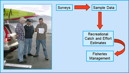 Field Survey Flow.
Field surveys and resulting sample data are used to generate catch and effort estimates. Two basic components are needed to calculate a catch estimate: 1) a fishing effort estimate and 2) a catch-rate estimate (catch per unit effort, CPUE). Estimates are used to manage California's diverse and economically important recreational fisheries. CDFW calculates catch and effort estimates; these estimates are shared with the Recreational Fisheries Information Network (RecFIN) for management, storage, and searchability.
CRFS estimates are used by the Fish and Game Commission, the Pacific Fishery Management Council, and others to make management decisions about California’s marine resources.
CRFS data and estimates are used in:
- Tracking in-season catches against annual harvest limits. The data are used in tracking certain overfished rockfish species such as yelloweye rockfish and cowcod
- Producing in-season salmon estimates in coordination with the CDFW Ocean Salmon Project
- Aiding the development of regulations including fishing seasons, bag limits, minimum size limits, and depth limits
- Stock assessments for individual fish species
Sample Design Stratification
The CRFS sampling design is stratified by:
Modes
The survey directly samples four main modes of access to recreational fisheries, where the vast majority of catch and effort occurs. Each mode presents unique challenges, involves unique sampling methodologies, and requires that modes to be sampled independently to allow production of robust estimates.
- Beaches and Banks: These access points are highly diffuse and require samplers to cover large geographic areas to intercept anglers.
- Charter/Party Boats: Sampling commercial passenger fishing vessels (CPFVs) can occur dockside when vessels land or onboard allowing for direct observation of catch (including discards).
- Private and Rental Boats: Anglers are intercepted at launch facilities as they return from their fishing trips.
- Man-made Structures: Piers, jetties and breakwaters are popular sites for shore-based anglers.
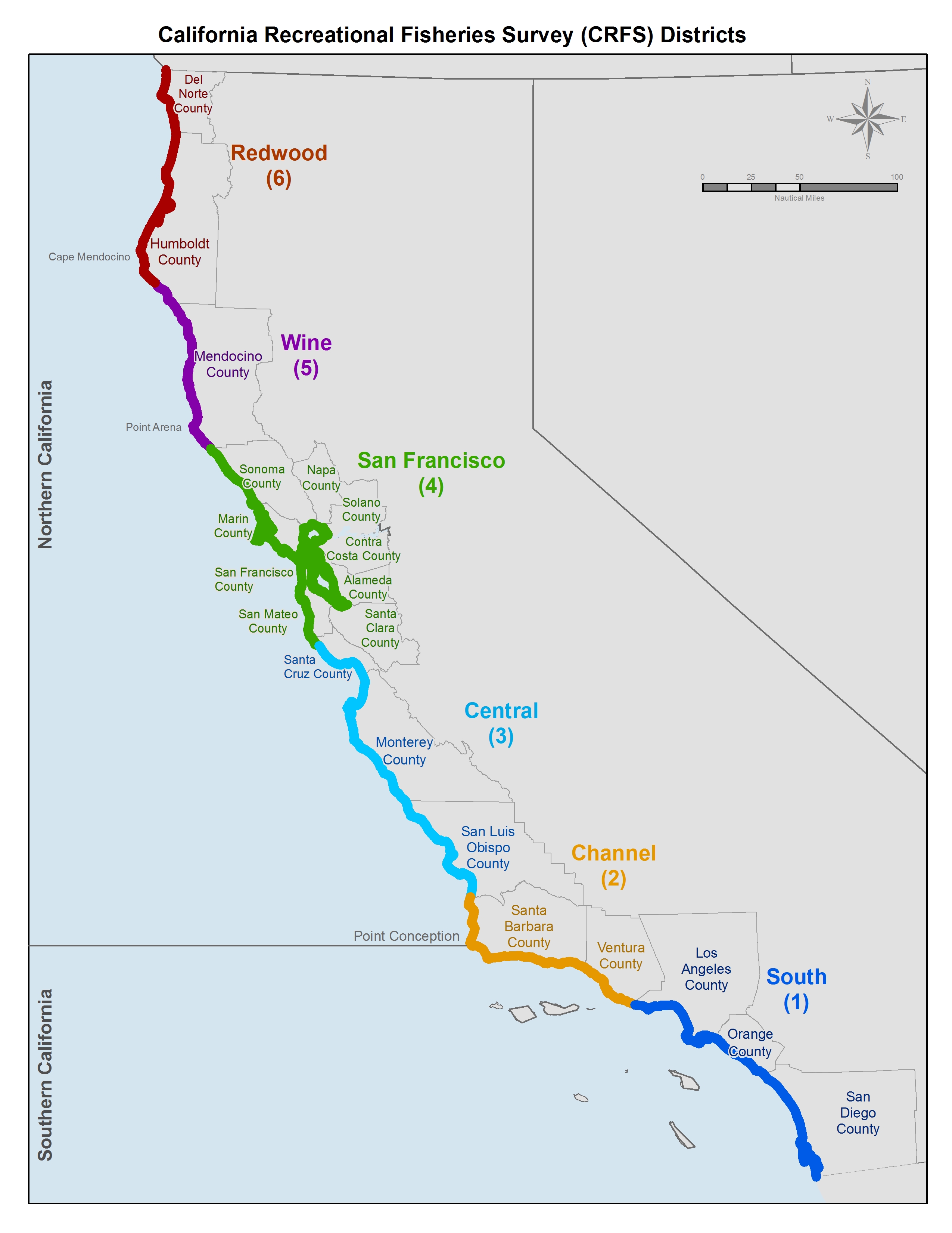
California has been divided into six geographic areas or districts for CRFS. The location of fishery management boundaries, distance recreational boats typically travel from major ports and county lines were taken into account when establishing district boundaries.
- South District – Los Angeles, Orange, and San Diego counties. This is a highly urbanized district with many marina and harbor facilities for boaters and dozens of piers and man-made structures that are heavily used.
- Channel District – Santa Barbara and Ventura counties. This district is an ecological transition zone for warm water and cold water fish species. High fishing effort occurs year-round.
- Central District – Santa Cruz, Monterey, and San Luis Obispo counties. There are five major ports for boaters with miles of open sandy coast for shore anglers.
- San Francisco District – Sonoma, Marin, San Francisco, and San Mateo counties on the coast, and the eight counties surrounding San Francisco and San Pablo bays (Alameda, Contra Costa, Solano, Sonoma, Marin, San Francisco, San Mateo and Santa Clara counties). This is a highly urbanized area which includes the state's largest estuary.
- Wine District – Mendocino County and the Shelter Cove section of Humboldt County. Fishing is more seasonal in this district with much of the coastline difficult to access for shore fishing.
- Redwood District – Del Norte County and the most of Humboldt County (excludes Shelter Cove section). Fishing is more seasonal in this district with much of the coastline difficult to access for shore fishing.
 California Recreational Fisheries Survey Districts (PDF)
The sample design takes into account that effort differs based on the type of day (weekdays or weekends/holidays). In general, fishing effort is higher on weekends and holidays than on weekdays.
Access-type
The sample design takes into account that effort is different based on private vs. public sites.
Day or nighttime fishing
The sample design takes into account that effort is different based daytime vs. nighttime fishing.
Water Area
The sample design takes into account that effort is different based on water area, whether it’s fishing in a nearshore area, offshore area, or in an enclosed bay or estuary.