Scorpion State Marine Reserve/Federal Marine Reserve

cliffside view down to ocean with protruding rocks and submerged kelp

Overview

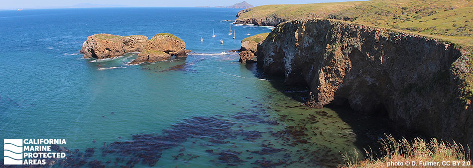
Scorpion State Marine Reserve (SMR) and the federal Scorpion Marine Reserve (FMR) are located south of mainland Santa Barbara on the northeast side of Santa Cruz Island, the largest of California’s Channel Islands. The SMR covers almost 10 square miles, includes a shoreline span of almost 3½ miles, and reaches depths greater than 760 feet. Where the SMR ends at three nautical miles from shore, the FMR continues farther offshore to meet the outer boundary of the surrounding Channel Islands National Marine Sanctuary.

This marine protected area (MPA) is fed by cold, nutrient-rich waters, which help to sustain a diverse web of marine life. Its sandy beaches and rocky shores transform to sandy and rocky seafloor beneath the surface, supporting eelgrass beds and dense kelp forests. Halfmoon, blacksmith, Pacific sardine, kelp bass and California sheephead swim through the kelp while California spiny lobster, sheep crab, and warty sea cucumber crawl along the sandy and rocky seafloor. Seasonally migrating yellowtail, barracuda, and bonito can be found in the open waters farther offshore, and marine mammals like California sea lions and harbor seals visit frequently.

Scorpion Anchorage, a small harbor, is only a one-hour boat ride from Ventura Harbor, and has one of the most accessible beaches for visiting Santa Cruz Island and the SMR. Visitors can see marine wildlife and a wide variety of birds such as black oystercatchers, peregrine falcons, pigeon guillemots, and even bald eagles.

Regulations

It is unlawful to injure, damage, take, or possess any living, geological, or cultural marine resource.

California Code of Regulations Title 14, Section 632(b)(110)(opens in new tab)

Note: The state and federal marine reserves share identical regulations.

Quick Facts

These facts are for the state marine reserve only.

MPA size: 9.64 square miles

Shoreline span: 3.4 miles

Depth range: 0 to 769 feet

Habitat composition*:

  • Rock: 0.62 square miles
  • Sand/mud: 7.37 square miles

*Habitat calculations are based on 3-dimensional area and may exceed the total MPA area listed above.

About Scorpion State Marine Reserve/Federal Marine Reserve

Natural History

fish with spiny fins nestled in algae covered rock crevice
A brown rockfish rests on a rocky reef at Scorpion SMR. photo © T. Turner, CC BY-NC 2.0

Scorpion SMR, and the entire Channel Islands region, is located at the convergence of warm currents that travel north up the Southern California coast and the cold California current that pushes south from Alaska. Nutrient-rich water, the mixing of temperatures, and the meeting of species from southern and northern ranges account for the rich and varied marine life found here.

Located about 20 miles off Santa Barbara, Santa Cruz Island is the largest of the Channel Islands, and features extremely diverse coastal and terrestrial habitats. The island's coastline is marked with steep cliffs, gigantic sea caves, coves, and sandy beaches. The rocky shoreline provides habitat for seabirds, like pelagic cormorants and California brown pelicans, and refuge for urchins and California mussels. The seafloor here includes a mix of sand and gravel with some patchy reefs and high-relief pinnacles. Eelgrass beds are found in the shallow sand and mud, while forests of giant kelp attach to rocky areas, providing shelter for kelp bass, lingcod, and cabezon.

While diving or snorkeling, it is common to see fish like blacksmith, halfmoon, kelp bass, opaleye, and garibaldi. When calm conditions allow for clear water, kayakers can see schools of fish between the giant kelp blades, seals and sea lions surfacing for air, and invertebrates like barnacles and mussels attached to the sea cave walls.

Cultural History

aerial view of boats around nearshore island
Scorpion Anchorage at Scorpion SMR. photo © R. Schwemmer, NOAA

For centuries, Native American Tribes in California have relied on marine and coastal resources. Many Native American Tribes in California continue to regularly harvest marine resources within their ancestral territories and maintain relationships with the coast for ongoing customary uses.

Ancestors of the Chumash people occupied Santa Cruz Island for at least 9,000 years. They used the tomol, a traditional redwood plank canoe, to travel between the islands and mainland. During the earliest recorded European visit to the island in 1769, Spanish explorers unintentionally left an iron cross staff at a local Chumash village. Considering it lost, they were surprised when a tomol paddled up next to their ship the following day to return the forgotten staff. The island was subsequently named Santa Cruz Island, which means “Island of the Holy Cross”.

Through a land grant from the Mexican government, Captain Andres Castillero became the first private owner of Santa Cruz Island in 1839. He sold it in 1857 to William Barron, a San Francisco businessman, who started a sheep operation there. By 1886, Justinian Caire, a French immigrant, had acquired all the shares of the Santa Cruz Island Company, and started a self-sustaining sheep and cattle ranch, vineyard, and grove of nut and fruit trees. Upon Caire’s death, a hotly contested land dispute began a decades-long legal battle over the Santa Cruz Island Company. The legal fight finally resolved with transfer of the property to The Nature Conservancy in the 1990s. Channel Islands National Park now owns and operates approximately 24 percent of Santa Cruz Island, and The Nature Conservancy, the University of California Natural Reserve System, and the Santa Cruz Island Foundation operate the remainder.

Much of the island is dedicated to scientific marine and terrestrial research and education. Channel Islands National Park was established in 1980 to protect Santa Rosa, Santa Cruz, San Miguel, Anacapa and Santa Barbara islands, and replace the previously designated Channel Islands National Monument, which had protected only Anacapa and Santa Barbara islands. The Channel Islands National Marine Sanctuary was also established in 1980, protecting 1,470 square miles of ocean up to six nautical miles offshore around each of the five islands.

Recreation

kayaker emerging from tunnel made by arched rock
A kayaker in a cavern at Scorpion SMR. photo © M. Baird, CC BY 2.0

Santa Cruz Island is the perfect place for a day trip or multi-night camping trip. Of the Northern Channel Islands, it is one of the easiest to access by boat. Trips operated through the National Park Service-authorized concessionaire, Island Packers, leave from Ventura Harbor and take about an hour to reach the island. During the short voyage it is common to see whale spouts, pods of dolphins, and many different seabirds.

The Channel Islands National Park Visitor Center on Santa Cruz Island is located at the Scorpion Ranch House, where a variety of interactive exhibits and resources can teach visitors about the island’s history. The hiking opportunities are endless on the island, and offer spectacular views of the SMR.

A rocky shoreline extends from Cavern Point to Potato Harbor in the SMR, but the sandy beach at Scorpion Anchorage makes for easy access. Visitors can enjoy popular water sports such as kayaking, snorkeling, and scuba diving. Kayakers can explore the nearshore waters filled with kelp forests, fish, and seabirds, and the island's rugged coastline, featuring caverns and rock arches. Divers and snorkelers can expect to see eelgrass meadows, feather boa kelp, surfgrass, giant kelp, urchins, nudibranchs, California sheephead and cabezon. Since no amenities are available on the island, visitors should bring water, sun protection, and other supplies. No fishing or other take of marine resources is allowed within the SMR or FMR.

Coordinates

This area is bounded by the mean high tide line and straight lines connecting the following points in the order listed:

34° 02.958' N. lat. 119° 35.500' W. long.;
34° 09.270' N. lat. 119° 35.500' W. long.;
34° 09.270' N. lat. 119° 32.800' W. long.; and
34° 02.700' N. lat. 119° 32.800' W. long.

Note: This area includes Scorpion State Marine Reserve and the adjoining federal Scorpion Marine Reserve. Coordinates are provided for outer boundaries of the joined state and federal areas.

The state reserve and federal reserve share identical regulations. For state reserve boundaries only, see California Code of Regulations Title 14, Section 632. For federal reserve boundaries only, see Code of Federal Regulations, Federal Register 15 Part 922 and 50 CFR Part 660.

Downloads for Scorpion State Marine Reserve/Federal Marine Reserve

Map

Map of Scorpion State Marine Reserve and the federal Scorpion Marine Reserve - click to enlarge in new tab

Facts, Map & Regulations

MPA fact sheet - click to enlarge in new tab